
FCCInfo.com
A Service of Cavell, Mertz & Associates, Inc.
(855) FCC-INFO
|
|
|
|  |
|
|||||||||||||||
|
|
KQOW Channel: 212A 90.3 MHz Bellingham, Washington Service: FM - A full-service FM station or application. Facility ID: 174445 Fac. Service: FM Analog & Digital Status: License Application Accepted: 08/15/2011 Application Granted: 08/23/2011 File Number: BLED-20110815AAC License Expires: 00/00/0000 Prefix Type: This is a license for a noncommercial educational FM station Application Type: License To Cover FCC Website Links: LMS Facility Details This Application CDBS Application Other KQOW Applications Other KQOW Applications in CDBS Including Superseded Applications Mailing Address Correspondence for KQOW Correspondence related to application BLED-20110815AAC Service Contour - Open Street Map or USGS Map (60 dBu) Service Contour - KML / Google Earth (60 dBu) Public Inspection Files Facility Type: NON-COMMERCIAL EDUC. FM Class: A, A Zone I; I-A; or II station; with 0.1kW-6kW ERP and a class contour distance <=28km Site Location: 48-48-03.4 N 122-27-44.6 W (NAD 83) Site Location: 48-48-04.0 N 122-27-40.0 W (Converted to NAD 27) Effective Radiated Power: 0.1 kW Transmitter Output Power: 0.116 kW Antenna Center HAAT: 95 m (312 ft.) Antenna Center AMSL: 186.9 m (613 ft.) Antenna Center HAG: 18 m (59 ft.) Calculated Site Elevation: 168.9 m. (554 ft.) Height Overall*: 45.7 m (150 ft.) (* As Filed In This Application, may differ from ASR Data, Below.) Directional Antenna Antenna Make/Model: Shivley 6810-IR-DA, one section Antenna ID: 100430 Polarization:
| ||||||||||||||||||
| Antenna Data for Antenna Id: 100430 KQOW FM File: BLED-20110815AAC Shivley - 6810-IR-DA, one section Service: FM | 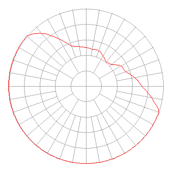 | ||||||||||||||||||
| Azimuth | Ratio | Azimuth | Ratio | Azimuth | Ratio | Azimuth | Ratio | ||||||||||||
| 0 | 0.498 | 10 | 0.483 | 20 | 0.485 | 30 | 0.444 | ||||||||||||
| 40 | 0.410 | 50 | 0.436 | 60 | 0.519 | 70 | 0.546 | ||||||||||||
| 80 | 0.640 | 90 | 0.722 | 100 | 0.860 | 110 | 1.000 | ||||||||||||
| 120 | 1.000 | 130 | 1.000 | 140 | 1.000 | 150 | 1.000 | ||||||||||||
| 160 | 1.000 | 170 | 1.000 | 180 | 1.000 | 190 | 1.000 | ||||||||||||
| 200 | 1.000 | 210 | 1.000 | 220 | 1.000 | 230 | 1.000 | ||||||||||||
| 240 | 1.000 | 250 | 1.000 | 260 | 1.000 | 270 | 1.000 | ||||||||||||
| 280 | 1.000 | 290 | 1.000 | 300 | 1.000 | 310 | 1.000 | ||||||||||||
| 320 | 0.886 | 330 | 0.704 | 340 | 0.559 | 350 | 0.518 | ||||||||||||
Structure Registration Number 1058268 Structure Type: Registered To: Mt. Constitution Sites, Inc. Structure Address: Twr 2 - 4435 Gooding Ave Bellingham, WA County Name: Whatcom County ASR Issued: 02/11/2022 Date Built: 10/15/1997 Site Elevation: 168.9 m (554 ft.) Structure Height: 45.7 m (150 ft.) Height Overall: 45.7 m (150 ft.) Overall Height AMSL: 214.6 m (704 ft.) FAA Determination: 06/24/1997 FAA Study #: 97-ANM-0605-OE FAA Circular #: 70/7460-1J Paint & Light FAA Chapters: 4, 8, 13 Removed expiration date from determination. Scenario 1./jjs/case#635066 48-48-03.0 N 122-27-45.0 W (NAD 83) 48-48-03.6 N 122-27-40.4 W (Converted to NAD 27) |
4518 University Way, N.e., Suite 310 Seattle, WA 98105 Phone: 206-543-2710 | Date: 08/15/2011 Application Certifier UNIVERSITY OF WASHINGTON BOARD OF REGENTS 4518 University Way, Ne, Suite 310 Seattle, WA 98105 Applicant TERRY W. DENBROOK 4518 University Way Ne Suite 310 Seattle, WA 98105 CHIEF ENGINEER KUOW ERNEST T. SANCHEZ The Sanchez Law Firm, P.c. | |||||||||||||||||