
FCCInfo.com
A Service of Cavell, Mertz & Associates, Inc.
(855) FCC-INFO
|
|
W262CW from 02/08/2016 W262CW from 09/05/2007 W262CW from 10/19/2004 |
|
|
||||||||||||||||
|
|
W262CW Channel: 262D 100.3 MHz Harrisburg, Pennsylvania Service: FX - A translator or application for a translator. Facility ID: 155485 Fac. Service: FX Programming Delivery Method: Unspecified Status: License Application Accepted: 12/06/2016 Application Granted: 12/09/2016 File Number: BLFT-20161206ABC License Expires: 00/00/0000 Prefix Type: This is a license for a translator Application Type: License To Cover FCC Website Links: LMS Facility Details This Application CDBS Application Other W262CW Applications Other W262CW Applications in CDBS Including Superseded Applications Mailing Address Correspondence for W262CW Correspondence related to application BLFT-20161206ABC Service Contour - Open Street Map or USGS Map (60 dBu) Service Contour - KML / Google Earth (60 dBu) Class: D, A Noncommercial educational operating with no more than 10W Site Location: 40-11-30.3 N 76-52-00.9 W (NAD 83) Site Location: 40-11-30.0 N 76-52-02.0 W (Converted to NAD 27) Effective Radiated Power: 0.25 kW Transmitter Output Power: 0.506 kW Antenna Center HAAT: 0 m Antenna Center AMSL: 311 m (1020 ft.) Antenna Center HAG: 37 m (121 ft.) Site Elevation: 274 m. (899 ft.) Height Overall*: 50 m (164 ft.) (* As Filed In This Application, may differ from ASR Data, Below.) Directional Antenna Antenna Make/Model: None Antenna ID: 124934 Polarization:
| ||||||||||||||||||
| Antenna Data for Antenna Id: 124934 W262CW FX File: BLFT-20161206ABC None - Service: FX | 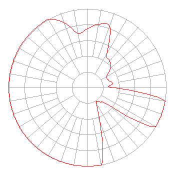 | ||||||||||||||||||
| Azimuth | Ratio | Azimuth | Ratio | Azimuth | Ratio | Azimuth | Ratio | ||||||||||||
| 0 | 0.745 | 10 | 0.817 | 20 | 0.820 | 30 | 0.490 | ||||||||||||
| 40 | 0.440 | 50 | 0.380 | 60 | 0.279 | 70 | 0.281 | ||||||||||||
| 80 | 0.320 | 90 | 0.320 | 100 | 1.000 | 110 | 1.000 | ||||||||||||
| 120 | 1.000 | 130 | 0.350 | 140 | 0.240 | 150 | 0.223 | ||||||||||||
| 160 | 0.450 | 170 | 1.000 | 180 | 1.000 | 190 | 1.000 | ||||||||||||
| 200 | 1.000 | 210 | 1.000 | 220 | 1.000 | 230 | 1.000 | ||||||||||||
| 240 | 1.000 | 250 | 1.000 | 260 | 1.000 | 270 | 1.000 | ||||||||||||
| 280 | 1.000 | 290 | 1.000 | 300 | 1.000 | 310 | 1.000 | ||||||||||||
| 320 | 1.000 | 330 | 1.000 | 340 | 0.877 | 350 | 0.699 | ||||||||||||
Structure Registration Number 1204946 Structure Type: TOWER Registered To: Triangle Communications, Inc Structure Address: Pleasant View Rd. New Cumberland, PA County Name: York County ASR Issued: 10/17/2006 Date Built: 10/12/2007 Site Elevation: 274 m (899 ft.) Structure Height: 36.6 m (120 ft.) Height Overall: 50.3 m (165 ft.) Overall Height AMSL: 324.3 m (1064 ft.) FAA Determination: 05/07/2006 FAA Study #: 2006-AEA-1412-OE Paint & Light FAA Chapters: NONE PRIOR STUDY 1993-AEA-1462-OE 40-11-30.3 N 76-52-00.9 W (NAD 83) 40-11-30.0 N 76-52-02.0 W (Converted to NAD 27) |
55 East Main Street Marlton, NJ 08053 Phone: 856-983-1662 | Date: 12/06/2016 Application Certifier HOPE CHRISTIAN CHURCH OF MARLTON, INC. 55 East Main Street Marlton, NJ 08053 Applicant WILLIAM C. LUEBKEMANN, JR. 55 East Main Street Marlton, NJ 08053 PRESIDENT/CHIEF ENGINEER MATTHEW MCCORMICK Fletcher, Heald & Hildreth, Plc 1300 North 17th Street 11th Floor Arlington, VA 22209 | |||||||||||||||||