
FCCInfo.com
A Service of Cavell, Mertz & Associates, Inc.
(855) FCC-INFO
|
|
WGDQ from 02/08/1993 |
|
|
||||||||||||||||
|
|
WGDQ Channel: 226C3 93.1 MHz Sumrall, Mississippi Service: FM - A full-service FM station or application. Facility ID: 68907 Fac. Service: FM Status: License 73.215 Station Application Accepted: 03/10/2008 Application Granted: 04/22/2008 File Number: BLH-20080310ADI License Expires: 00/00/0000 Prefix Type: This is a license for a commercial FM station Application Type: Amendment FCC Website Links: LMS Facility Details This Application CDBS Application Other WGDQ Applications Other WGDQ Applications in CDBS Including Superseded Applications Mailing Address Correspondence for WGDQ Correspondence related to application BLH-20080310ADI Service Contour - Open Street Map or USGS Map (60 dBu) Service Contour - KML / Google Earth (60 dBu) Public Inspection Files Facility Type: FM STATION Class: C3, A Zone II station; with 6kW-25kW ERP and a class contour distance 28km-39km Site Location: 31-22-58.6 N 89-23-43.2 W (NAD 83) Site Location: 31-22-58.0 N 89-23-43.0 W (Converted to NAD 27) Effective Radiated Power: 25 kW Transmitter Output Power: 5 kW Antenna Center HAAT: 92 m (302 ft.) Antenna Center AMSL: 165 m (541 ft.) Antenna Center HAG: 104 m (341 ft.) Calculated Site Elevation: 61 m. (200 ft.) Height Overall*: 116 m (381 ft.) (* As Filed In This Application, may differ from ASR Data, Below.) Directional Antenna Antenna Make/Model: Propagation System Inc PSIFM-8C-DA Antenna ID: 75295 Polarization: | ||||||||||||||||||
| Antenna Data for Antenna Id: 75295 WGDQ FM File: BLH-20080310ADI Propagation System Inc - PSIFM-8C-DA Service: FM | 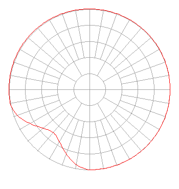 | ||||||||||||||||||
| Azimuth | Ratio | Azimuth | Ratio | Azimuth | Ratio | Azimuth | Ratio | ||||||||||||
| 0 | 1.000 | 10 | 1.000 | 20 | 1.000 | 30 | 1.000 | ||||||||||||
| 40 | 1.000 | 50 | 1.000 | 60 | 1.000 | 70 | 1.000 | ||||||||||||
| 80 | 1.000 | 90 | 1.000 | 100 | 1.000 | 110 | 1.000 | ||||||||||||
| 120 | 1.000 | 130 | 1.000 | 140 | 1.000 | 150 | 1.000 | ||||||||||||
| 160 | 1.000 | 170 | 1.000 | 180 | 1.000 | 190 | 0.950 | ||||||||||||
| 200 | 0.850 | 210 | 0.750 | 220 | 0.700 | 230 | 0.750 | ||||||||||||
| 240 | 0.850 | 250 | 0.950 | 260 | 1.000 | 270 | 1.000 | ||||||||||||
| 280 | 1.000 | 290 | 1.000 | 300 | 1.000 | 310 | 1.000 | ||||||||||||
| 320 | 1.000 | 330 | 1.000 | 340 | 1.000 | 350 | 1.000 | ||||||||||||
Structure Registration Number 1236941 Structure Type: TOWER Registered To: Unity Broadcasters Structure Address: 7.1 Miles Northwest Hattiesburg, MS County Name: Forrest County ASR Issued: 12/05/2002 Date Built: 07/01/2005 Site Elevation: 61 m (200 ft.) Structure Height: 115.8 m (380 ft.) Height Overall: 116.4 m (382 ft.) Overall Height AMSL: 177.4 m (582 ft.) FAA Determination: 04/17/2002 FAA Study #: 02-ASO-2149-OE FAA Circular #: 70/7460-1K Paint & Light FAA Chapters: 3, 4, 5, 12 31-22-58.6 N 89-23-43.2 W (NAD 83) 31-22-58.0 N 89-23-43.0 W (Converted to NAD 27) |
1204 Gravel Line Road Hattiesburg, MS 39401 Phone: 601-467-9810 Administrator of the estate of Vernon C. Floyd | Date: 03/10/2008 Application Certifier UNITY BROADCASTERS 704 River Street Hattiesburg, MS 39401 Applicant VERNON FLOYD 1204 Graveline St Hattiesburg, MS 39401 CHIEF ENGINEER JERROLD MILLER Miller And Neely, Pc | |||||||||||||||||