
FCCInfo.com
A Service of Cavell, Mertz & Associates, Inc.
(855) FCC-INFO
|
|
W295BL from 08/26/2004 |
|
|
||||||||||||||||
|
|
W295BL Channel: 295D 106.9 MHz Manchester, New Hampshire Service: FX - A translator or application for a translator. Facility ID: 139440 Fac. Service: FX Programming Delivery Method: Unspecified Status: License Application Accepted: 03/14/2016 Application Granted: 03/21/2016 File Number: BLFT-20160314ABE License Expires: 00/00/0000 Prefix Type: This is a license for a translator Application Type: License To Cover FCC Website Links: LMS Facility Details This Application CDBS Application Other W295BL Applications Other W295BL Applications in CDBS Including Superseded Applications Mailing Address Correspondence for W295BL Correspondence related to application BLFT-20160314ABE Service Contour - Open Street Map or USGS Map (60 dBu) Service Contour - KML / Google Earth (60 dBu) Class: D, A Noncommercial educational operating with no more than 10W Site Location: 42-59-34.3 N 71-27-48.2 W (NAD 83) Site Location: 42-59-34.0 N 71-27-50.0 W (Converted to NAD 27) Effective Radiated Power: 0.25 kW Transmitter Output Power: 0.111 kW Antenna Center HAAT: 0 m Antenna Center AMSL: 147 m (482 ft.) Antenna Center HAG: 82 m (269 ft.) Site Elevation: 65 m. (213 ft.) Height Overall*: 91 m (299 ft.) (* As Filed In This Application, may differ from ASR Data, Below.) Directional Antenna Antenna Make/Model: None Antenna ID: 16149 Polarization:
| ||||||||||||||||||
| Antenna Data for Antenna Id: 16149 W295BL FX File: BLFT-20160314ABE None - Service: FX Pattern and Field Values Include a 270° Clockwise Rotation | 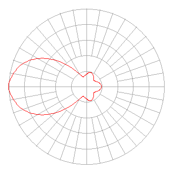 | ||||||||||||||||||
| Azimuth | Ratio | Azimuth | Ratio | Azimuth | Ratio | Azimuth | Ratio | ||||||||||||
| 0 | 0.157 | 10 | 0.181 | 20 | 0.187 | 30 | 0.171 | ||||||||||||
| 40 | 0.140 | 50 | 0.123 | 60 | 0.135 | 70 | 0.160 | ||||||||||||
| 80 | 0.182 | 90 | 0.193 | 100 | 0.182 | 110 | 0.160 | ||||||||||||
| 120 | 0.135 | 130 | 0.123 | 140 | 0.140 | 150 | 0.171 | ||||||||||||
| 160 | 0.187 | 170 | 0.181 | 180 | 0.157 | 190 | 0.142 | ||||||||||||
| 200 | 0.134 | 210 | 0.190 | 220 | 0.329 | 230 | 0.528 | ||||||||||||
| 240 | 0.718 | 250 | 0.866 | 260 | 0.952 | 270 | 1.000 | ||||||||||||
| 280 | 0.952 | 290 | 0.866 | 300 | 0.718 | 310 | 0.528 | ||||||||||||
| 320 | 0.329 | 330 | 0.190 | 340 | 0.134 | 350 | 0.142 | ||||||||||||
Structure Registration Number 1056550 Structure Type: BTWR Registered To: BRADY SULLIVAN PLAZA LLC Structure Address: 1000 Elm St Manchester, NH County Name: Hillsborough County ASR Issued: 04/30/2010 Date Built: 10/09/1997 Site Elevation: 64.6 m (212 ft.) Structure Height: 77.6 m (255 ft.) Height Overall: 90.8 m (298 ft.) Overall Height AMSL: 155.4 m (510 ft.) FAA Determination: 09/15/1998 FAA Study #: 98-ANE-0088-OE FAA Circular #: 70/7460-1J Paint & Light FAA Chapters: 3, 4, 5, 13 Removed expiration date from determination. Scenario 1./jjs/case#635066 42-59-34.0 N 71-27-48.0 W (NAD 83) 42-59-33.7 N 71-27-49.8 W (Converted to NAD 27) |
73 Kercheval Avenue Grosse Pointe Farms, MI 48236 Phone: 313-886-7070 | Date: 03/14/2016 Application Certifier BASIC HOLDINGS, LLC 35 South Main Street Suite 300 Hanover, NH 03755 Applicant ROBERT M. SMITH JR. R.m. Smith Associates P.o. Box 345 Jensen Beach, FL 34958 TECHNICAL CONSULTANT DAVID G. O'NEIL, ESQ. Rini O'neil, Pc 1200 New Hampshire Avenue, Nw Suite 600 Washington, DC 20036 | |||||||||||||||||