
FCCInfo.com
A Service of Cavell, Mertz & Associates, Inc.
(855) FCC-INFO
|
|
|
|
|
||||||||||||||||
|
|
W256AJ Channel: 256D 99.1 MHz Utica, New York Service: FX - A translator or application for a translator. Facility ID: 22187 Fac. Service: FX Programming Delivery Method: Unspecified Status: License Application Accepted: 09/26/2012 Application Granted: 10/26/2012 File Number: BLFT-20120926AFQ License Expires: 00/00/0000 Prefix Type: This is a license for a translator Application Type: License To Cover FCC Website Links: LMS Facility Details This Application CDBS Application Other W256AJ Applications Other W256AJ Applications in CDBS Including Superseded Applications Mailing Address Correspondence for W256AJ Correspondence related to application BLFT-20120926AFQ Service Contour - Open Street Map or USGS Map (60 dBu) Service Contour - KML / Google Earth (60 dBu) Class: D, A Noncommercial educational operating with no more than 10W Site Location: 43-08-46.3 N 75-10-38.6 W (NAD 83) Site Location: 43-08-46.0 N 75-10-40.0 W (Converted to NAD 27) Effective Radiated Power: 0.25 kW Transmitter Output Power: 0.1 kW Antenna Center HAAT: 237.1 m Horiz.; 0 m Vert. Antenna Center AMSL: 481 m (1578 ft.) Antenna Center HAG: 118 m (387 ft.) Site Elevation: 363 m. (1191 ft.) Height Overall*: 138 m (453 ft.) (* As Filed In This Application, may differ from ASR Data, Below.) Directional Antenna Antenna Make/Model: None Antenna ID: 16149 Polarization:
| ||||||||||||||||||
| Antenna Data for Antenna Id: 16149 W256AJ FX File: BLFT-20120926AFQ None - Service: FX Pattern and Field Values Include a 255° Clockwise Rotation | 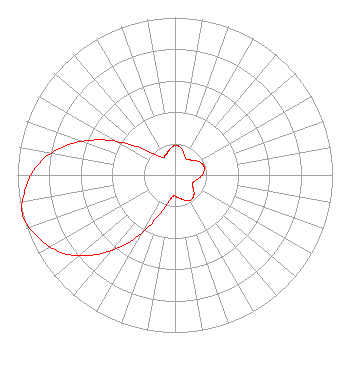 | ||||||||||||||||||
| Azimuth | Ratio | Azimuth | Ratio | Azimuth | Ratio | Azimuth | Ratio | ||||||||||||
| 5 | 0.187 | 15 | 0.171 | 25 | 0.140 | 35 | 0.123 | ||||||||||||
| 45 | 0.135 | 55 | 0.160 | 65 | 0.182 | 75 | 0.193 | ||||||||||||
| 85 | 0.182 | 95 | 0.160 | 105 | 0.135 | 115 | 0.123 | ||||||||||||
| 125 | 0.140 | 135 | 0.171 | 145 | 0.187 | 155 | 0.181 | ||||||||||||
| 165 | 0.157 | 175 | 0.142 | 185 | 0.134 | 195 | 0.190 | ||||||||||||
| 205 | 0.329 | 215 | 0.528 | 225 | 0.718 | 235 | 0.866 | ||||||||||||
| 245 | 0.952 | 255 | 1.000 | 265 | 0.952 | 275 | 0.866 | ||||||||||||
| 285 | 0.718 | 295 | 0.528 | 305 | 0.329 | 315 | 0.190 | ||||||||||||
| 325 | 0.134 | 335 | 0.142 | 345 | 0.157 | 355 | 0.181 | ||||||||||||
Structure Registration Number 1002978 Structure Type: GTOWER Registered To: PTI US Assets I, LLC Structure Address: Smith Hill Utica, NY County Name: Oneida County ASR Issued: 06/10/2019 Date Built: 01/01/1973 Site Elevation: 362.7 m (1190 ft.) Structure Height: 138.1 m (453 ft.) Height Overall: 138.1 m (453 ft.) Overall Height AMSL: 500.8 m (1643 ft.) FAA Determination: 06/02/2017 FAA Study #: 2017-AEA-3734-OE FAA Circular #: 70/7460-1L Paint & Light FAA Chapters: 4, 8, 12 PRIOR STUDY 2016-AEA-3201-OE 43-08-46.9 N 75-10-42.1 W (NAD 83) 43-08-46.6 N 75-10-43.5 W (Converted to NAD 27) |
235 Walton Street Syracuse, NY 13202 Phone: 315-472-9111 Limited Liability Company | Date: 09/26/2012 Application Certifier GALAXY UTICA LICENSEE, LLC 235 Walton Street Syracuse, NY 13202-1351 Applicant CHARLES WILLIAMSON Digital Radio Engineering, Inc. 2927 Us Route 6 Slate Hill, NY 10973 TECHNICAL CONSULTANT SALLY A. BUCKMAN, ESQ. Lerman Senter Pllc 2000 K Street, Nw Suite 600 Washington, DC 20006 | |||||||||||||||||