
FCCInfo.com
A Service of Cavell, Mertz & Associates, Inc.
(855) FCC-INFO
|
|
WKZF from 10/24/2014 WKZF from 10/20/2000 WKZF from 07/13/1999 |
|  |
|
|||||||||||||||
|
|
WKZF Channel: 272A 102.3 MHz Morton, Illinois Service: FM - A full-service FM station or application. Facility ID: 43877 Fac. Service: FM Status: License 73.215 Station Application Accepted: 03/01/2010 Application Granted: 03/18/2010 File Number: BLH-20100301ACY License Expires: 00/00/0000 Prefix Type: This is a license for a commercial FM station Application Type: License To Cover FCC Website Links: LMS Facility Details This Application CDBS Application Other WKZF Applications Other WKZF Applications in CDBS Including Superseded Applications Mailing Address Correspondence for WKZF Correspondence related to application BLH-20100301ACY Service Contour - Open Street Map or USGS Map (60 dBu) Service Contour - KML / Google Earth (60 dBu) Public Inspection Files History Cards for WKZF Facility Type: FM STATION Class: A, A Zone I; I-A; or II station; with 0.1kW-6kW ERP and a class contour distance <=28km Site Location: 40-43-22.1 N 89-30-40.3 W (NAD 83) Site Location: 40-43-22.0 N 89-30-40.0 W (Converted to NAD 27) Effective Radiated Power: 4.1 kW Transmitter Output Power: 1.85 kW Antenna Center HAAT: 121.9 m (400 ft.) Antenna Center AMSL: 319.6 m (1049 ft.) Antenna Center HAG: 106.2 m (348 ft.) Calculated Site Elevation: 213.4 m. (700 ft.) Height Overall*: 137.2 m (450 ft.) (* As Filed In This Application, may differ from ASR Data, Below.) Directional Antenna Antenna Make/Model: Jampro JMPC-3R-DA, three sections Antenna ID: 90554 Polarization: | ||||||||||||||||||
| Antenna Data for Antenna Id: 90554 WKZF FM File: BLH-20100301ACY Jampro - JMPC-3R-DA, three sections Service: FM | 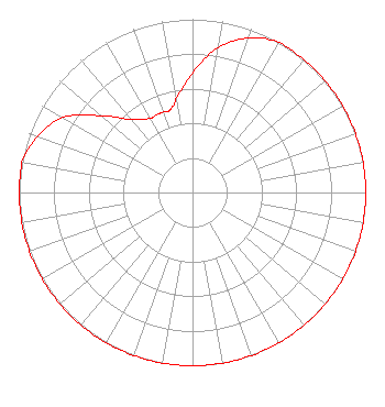 | ||||||||||||||||||
| Azimuth | Ratio | Azimuth | Ratio | Azimuth | Ratio | Azimuth | Ratio | ||||||||||||
| 0 | 0.690 | 10 | 0.850 | 20 | 0.950 | 30 | 1.000 | ||||||||||||
| 40 | 1.000 | 50 | 1.000 | 60 | 1.000 | 70 | 1.000 | ||||||||||||
| 80 | 1.000 | 90 | 1.000 | 100 | 1.000 | 110 | 1.000 | ||||||||||||
| 120 | 1.000 | 130 | 1.000 | 140 | 1.000 | 150 | 1.000 | ||||||||||||
| 160 | 1.000 | 170 | 1.000 | 180 | 1.000 | 190 | 1.000 | ||||||||||||
| 200 | 1.000 | 210 | 1.000 | 220 | 1.000 | 230 | 1.000 | ||||||||||||
| 240 | 1.000 | 250 | 1.000 | 260 | 1.000 | 270 | 1.000 | ||||||||||||
| 280 | 1.000 | 290 | 0.950 | 300 | 0.865 | 310 | 0.690 | ||||||||||||
| 320 | 0.550 | 330 | 0.494 | 335 | 0.494 | 340 | 0.494 | ||||||||||||
| 345 | 0.494 | 350 | 0.550 | ||||||||||||||||
Structure Registration Number 1004501 Structure Type: TOWER Registered To: VB-S1 Assets, LLC Structure Address: 22484 Grosenbach Rd Washington, IL County Name: Tazewell County ASR Issued: 01/30/2018 Date Built: 01/01/1961 Site Elevation: 213.4 m (700 ft.) Structure Height: 135.9 m (446 ft.) Height Overall: 137.2 m (450 ft.) Overall Height AMSL: 350.5 m (1150 ft.) Paint & Light FAA Chapters: 1, 3, 12, 21 40-43-22.0 N 89-30-40.0 W (NAD 83) 40-43-21.9 N 89-30-39.7 W (Converted to NAD 27) |
904 Grand Ave. Wausau, WI 54403 Phone: 000-000-0000 Corporation | Date: 03/01/2010 Application Certifier MONTEREY LICENSES, LLC 2511 Garden Road Building A, Suite 104 Monterey, CA 93940 Applicant ROY P. STYPE, III P. O. Box 807 2324 North Cleveland-massillon Road Bath, OH 44210-0807 CONSULTING ENGINEER DAVID D. OXENFORD Davis Wright Tremaine Llp | |||||||||||||||||
| |||||||||||||||||||