
FCCInfo.com
A Service of Cavell, Mertz & Associates, Inc.
(855) FCC-INFO
|
|
|
|  |
|
|||||||||||||||
|
|
KYFP Channel: 206C1 89.1 MHz Palestine, Texas Service: FM - A full-service FM station or application. Facility ID: 85164 Fac. Service: FM Status: License Application Accepted: 11/30/2006 Application Granted: 12/15/2006 File Number: BLED-20061130ABL License Expires: 00/00/0000 Prefix Type: This is a license for a noncommercial educational FM station Application Type: License To Cover FCC Website Links: LMS Facility Details This Application CDBS Application Other KYFP Applications Other KYFP Applications in CDBS Including Superseded Applications Mailing Address Correspondence for KYFP Correspondence related to application BLED-20061130ABL Service Contour - Open Street Map or USGS Map (60 dBu) Service Contour - KML / Google Earth (60 dBu) Public Inspection Files Facility Type: NON-COMMERCIAL EDUC. FM Class: C1, A Zone II station; with 50kW-100kW ERP and a class contour distance 52km-72km Site Location: 32-00-12.6 N 95-43-06.9 W (NAD 83) Site Location: 32-00-12.0 N 95-43-06.0 W (Converted to NAD 27) Effective Radiated Power: 100 kW Transmitter Output Power: 25 kW Antenna Center HAAT: 148 m (486 ft.) Antenna Center AMSL: 282.3 m (926 ft.) Antenna Center HAG: 146 m (479 ft.) Site Elevation: 136.3 m. (447 ft.) Height Overall*: 152 m (499 ft.) (* As Filed In This Application, may differ from ASR Data, Below.) Directional Antenna Antenna Make/Model: Systems With Reliability Inc. FM10/4 DA Antenna ID: 70983 Polarization:
| ||||||||||||||||||
| Antenna Data for Antenna Id: 70983 KYFP FM File: BLED-20061130ABL Systems With Reliability Inc. - FM10/4 DA Service: FM | 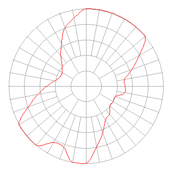 | ||||||||||||||||||
| Azimuth | Ratio | Azimuth | Ratio | Azimuth | Ratio | Azimuth | Ratio | ||||||||||||
| 0 | 1.000 | 10 | 1.000 | 20 | 1.000 | 30 | 1.000 | ||||||||||||
| 40 | 1.000 | 50 | 1.000 | 60 | 0.796 | 70 | 0.634 | ||||||||||||
| 80 | 0.505 | 90 | 0.505 | 100 | 0.505 | 110 | 0.402 | ||||||||||||
| 120 | 0.402 | 130 | 0.402 | 140 | 0.473 | 150 | 0.505 | ||||||||||||
| 160 | 0.634 | 170 | 0.796 | 180 | 1.000 | 190 | 1.000 | ||||||||||||
| 200 | 0.841 | 210 | 0.841 | 220 | 1.000 | 230 | 1.000 | ||||||||||||
| 240 | 1.000 | 250 | 0.796 | 260 | 0.634 | 270 | 0.505 | ||||||||||||
| 280 | 0.402 | 290 | 0.355 | 300 | 0.355 | 310 | 0.402 | ||||||||||||
| 320 | 0.505 | 330 | 0.634 | 340 | 0.796 | 350 | 0.891 | ||||||||||||
Structure Registration Number 1049315 [ASR Heights Differ from KYFP Application] Structure Type: GTOWER Registered To: Bible Broadcasting Network, Inc. Structure Address: On County Rd 486; 0.9 Mi Northwest Of East Farm To Market Rd (county Rd 837) Bradford, TX County Name: Anderson County ASR Issued: 10/11/2022 Date Built: 01/01/1989 Site Elevation: 135.9 m (446 ft.) Structure Height: 143.3 m (470 ft.) Height Overall: 155.8 m (511 ft.) Overall Height AMSL: 291.7 m (957 ft.) FAA Determination: 10/06/2022 FAA Study #: 2022-ASW-14587-OE Paint & Light FAA Chapters: 1, 3, 4, 13, 21 PRIOR STUDY 2012-ASW-7153-OE 32-00-13.3 N 95-43-07.5 W (NAD 83) 32-00-12.7 N 95-43-06.6 W (Converted to NAD 27) |
11530 Carmel Commons Blvd Charlotte, NC 28226 Phone: 704-523-5555 Not-for-Profit | Date: 11/30/2006 Application Certifier BIBLE BROADCASTING NETWORK, INC. 11530 Carmel Commons Blvd. Charlotte, NC 28226 Applicant WAYNE S. REESE, PRESIDENT Munn-reese, President Consulting Engineer Coldwater, MI 49036-0220 CONSULTING ENGINEER GARY S. SMITHWICK, ESQ. Smithwick & Belendiuk, P.c. | |||||||||||||||||