
FCCInfo.com
A Service of Cavell, Mertz & Associates, Inc.
(855) FCC-INFO
|
|
W277CT from 07/17/1998 W277CT from 10/10/1996 |
|
|
||||||||||||||||
|
|
W277CT Channel: 277D 103.3 MHz Petersburg, Virginia Service: FX - A translator or application for a translator. Facility ID: 18868 Fac. Service: FX Programming Delivery Method: Unspecified Status: License Application Accepted: 09/02/2015 Application Granted: 10/01/2015 File Number: BLFT-20150902ACM License Expires: 00/00/0000 Prefix Type: This is a license for a translator Application Type: License To Cover FCC Website Links: LMS Facility Details This Application CDBS Application Other W277CT Applications Other W277CT Applications in CDBS Including Superseded Applications Mailing Address Correspondence for W277CT Correspondence related to application BLFT-20150902ACM Service Contour - Open Street Map or USGS Map (60 dBu) Service Contour - KML / Google Earth (60 dBu) Class: D, A Noncommercial educational operating with no more than 10W Site Location: 37-15-30.5 N 77-23-39.0 W (NAD 83) Site Location: 37-15-30.0 N 77-23-40.1 W (Converted to NAD 27) Effective Radiated Power: 0.25 kW Transmitter Output Power: 0.505 kW Antenna Center HAAT: 0 m Antenna Center AMSL: 134 m (440 ft.) Antenna Center HAG: 128 m (420 ft.) Site Elevation: 6 m. (20 ft.) Height Overall*: 132 m (433 ft.) (* As Filed In This Application, may differ from ASR Data, Below.) Directional Antenna Antenna Make/Model: None Antenna ID: 121047 Polarization:
| ||||||||||||||||||
| Antenna Data for Antenna Id: 121047 W277CT FX File: BLFT-20150902ACM None - Service: FX Pattern and Field Values Include a 150° Clockwise Rotation | 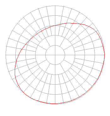 | ||||||||||||||||||
| Azimuth | Ratio | Azimuth | Ratio | Azimuth | Ratio | Azimuth | Ratio | ||||||||||||
| 0 | 0.594 | 10 | 0.628 | 20 | 0.682 | 30 | 0.738 | ||||||||||||
| 40 | 0.815 | 50 | 0.897 | 60 | 0.953 | 70 | 0.973 | ||||||||||||
| 80 | 0.983 | 90 | 1.000 | 100 | 0.992 | 110 | 0.988 | ||||||||||||
| 120 | 0.988 | 130 | 0.983 | 140 | 0.983 | 150 | 0.983 | ||||||||||||
| 160 | 0.983 | 170 | 0.983 | 180 | 0.988 | 190 | 0.988 | ||||||||||||
| 200 | 0.992 | 210 | 1.000 | 220 | 0.991 | 230 | 0.963 | ||||||||||||
| 240 | 0.923 | 250 | 0.862 | 260 | 0.797 | 270 | 0.731 | ||||||||||||
| 280 | 0.676 | 290 | 0.628 | 300 | 0.594 | 310 | 0.571 | ||||||||||||
| 320 | 0.558 | 330 | 0.553 | 340 | 0.558 | 350 | 0.571 | ||||||||||||
Structure Registration Number 1017499 [ASR Heights Differ from W277CT Application] Structure Type: TOWER Registered To: Richmond Christian Radio Corporation, Inc. Structure Address: Ne Corner Of Conduit Rd And Temple Ave Colonial Heights, VA County Name: Colonial Heights city ASR Issued: 01/06/2014 Date Built: 04/13/1987 Site Elevation: 5.5 m (18 ft.) Structure Height: 131.1 m (430 ft.) Height Overall: 132 m (433 ft.) Overall Height AMSL: 137.5 m (451 ft.) FAA Determination: 09/17/1986 FAA Study #: 86-AEA-1287-OE Paint & Light FAA Chapters: 1, 3, 4, 13, 21 RED LIGHTS/PAINT 37-15-31.0 N 77-23-39.0 W (NAD 83) 37-15-30.5 N 77-23-40.1 W (Converted to NAD 27) |
7924 Lasley Forest Road Lewisville, NC 27023 Phone: 336-946-0197 | Date: 09/02/2015 Application Certifier RICHMOND CHRISTIAN RADIO CORPORATION, INC. 7924 Lasley Forest Road Lewisville, NC 27023 Applicant LESTER ELTON 309 Smith Grove Rd. Forest City, NC 28043 ENGINEER PETER GUTMANN, ESQ. Womble Carlyle Sandridge & Rice, Llp 1200 19th Street Fifth Floor Washington, DC 20036 | |||||||||||||||||