
FCCInfo.com
A Service of Cavell, Mertz & Associates, Inc.
(855) FCC-INFO
|
|
WNJS-FM from 06/22/2023 |
|
|
||||||||||||||||
|
|
WTHA Channel: 201A 88.1 MHz Berlin, New Jersey Service: FM - A full-service FM station or application. Facility ID: 48486 Fac. Service: FM Status: License Application Accepted: 07/17/2018 Application Granted: 07/26/2018 File Number: BMLED-20180717AAW License Expires: 00/00/0000 Prefix Type: This is a modification of license for a noncommercial educational FM station Application Type: Minor Modification FCC Website Links: LMS Facility Details This Application CDBS Application Other WTHA Applications Other WTHA Applications in CDBS Including Superseded Applications Mailing Address Correspondence for WTHA Correspondence related to application BMLED-20180717AAW Service Contour - Open Street Map or USGS Map (60 dBu) Service Contour - KML / Google Earth (60 dBu) Public Inspection Files Facility Type: NON-COMMERCIAL EDUC. FM Class: A, A Zone I; I-A; or II station; with 0.1kW-6kW ERP and a class contour distance <=28km Site Location: 39-43-41.4 N 74-50-37.6 W (NAD 83) Site Location: 39-43-41.0 N 74-50-39.0 W (Converted to NAD 27) Effective Radiated Power: 0.001 kW Horiz. ; 0.08 kW Vert. Transmitter Output Power: 0.117 kW Antenna Center HAAT: 287 m (942 ft.) Antenna Center AMSL: 313 m (1027 ft.) Antenna Center HAG: 279 m (915 ft.) Site Elevation: 34.1 m. (112 ft.) Height Overall*: 285.7 m (937 ft.) (* As Filed In This Application, may differ from ASR Data, Below.) Directional Antenna Antenna Make/Model: Systems With Reliability Inc. FMEES/1-DA Antenna ID: 80943 Polarization:
| ||||||||||||||||||
| Antenna Data for Antenna Id: 80943 WTHA FM File: BMLED-20180717AAW Systems With Reliability Inc. - FMEES/1-DA Service: FM | 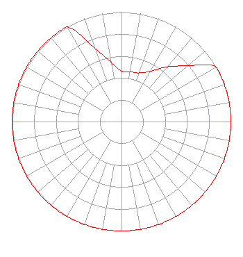 | ||||||||||||||||||
| Azimuth | Ratio | Azimuth | Ratio | Azimuth | Ratio | Azimuth | Ratio | ||||||||||||
| 0 | 0.462 | 10 | 0.462 | 20 | 0.473 | 30 | 0.531 | ||||||||||||
| 40 | 0.653 | 50 | 0.794 | 60 | 1.000 | 70 | 1.000 | ||||||||||||
| 80 | 1.000 | 90 | 1.000 | 100 | 1.000 | 110 | 1.000 | ||||||||||||
| 120 | 1.000 | 130 | 1.000 | 140 | 1.000 | 150 | 1.000 | ||||||||||||
| 160 | 1.000 | 170 | 1.000 | 180 | 1.000 | 190 | 1.000 | ||||||||||||
| 200 | 1.000 | 210 | 1.000 | 220 | 1.000 | 230 | 1.000 | ||||||||||||
| 240 | 1.000 | 250 | 1.000 | 260 | 1.000 | 270 | 1.000 | ||||||||||||
| 280 | 1.000 | 290 | 1.000 | 300 | 1.000 | 310 | 1.000 | ||||||||||||
| 320 | 1.000 | 330 | 1.000 | 340 | 0.716 | 350 | 0.550 | ||||||||||||
Structure Registration Number 1045125 Structure Type: Registered To: NEW JERSEY PUBLIC BROADCASTING AUTHORITY Structure Address: Arrowhead Dr .75 Km N Of Chew Rd Cr 536 Waterford Township, NJ County Name: Camden County ASR Issued: 06/14/2016 Date Built: 01/01/1972 Site Elevation: 34.1 m (112 ft.) Structure Height: 250.5 m (822 ft.) Height Overall: 285.7 m (937 ft.) Overall Height AMSL: 319.8 m (1049 ft.) FAA Determination: 10/23/1984 FAA Study #: 84-AEA-2005-OE FAA Circular #: 70/7460-1F Paint & Light FAA Chapters: 4, 6, 9 12/12/1984 letter from NJ state to FAA confirmed tower is lit per FAA Chapters 4,6,9. 39-43-41.0 N 74-50-38.0 W (NAD 83) 39-43-40.6 N 74-50-39.4 W (Converted to NAD 27) |
Warminster, PA 18974 Phone: 215-674-8002 Not-for-Profit | Date: 07/17/2018 Application Certifier WHYY, INC. 150 North Sixth Street Independence Mall West Philadelphia, PA 19106 Applicant JEFFREY J DEPOLO Broadcast Sciences Llc 1240 Horseshoe Trail Malvern, PA 19355 CONSULTANT STEVEN C. SCHAFFER Garvey Schubert Barer | |||||||||||||||||
| |||||||||||||||||||