
FCCInfo.com
A Service of Cavell, Mertz & Associates, Inc.
(855) FCC-INFO
|
|
|
|
|
||||||||||||||||
|
|
WHUS Channel: 219B1 91.7 MHz Storrs, Connecticut Service: FM - A full-service FM station or application. Facility ID: 65451 Fac. Service: FM Analog & Digital Status: License Application Accepted: 04/13/1999 Application Granted: 05/20/1999 File Number: BLED-19990413KA License Expires: 00/00/0000 Prefix Type: This is a license for a noncommercial educational FM station Application Type: License To Cover FCC Website Links: LMS Facility Details This Application CDBS Application Other WHUS Applications Other WHUS Applications in CDBS Including Superseded Applications Mailing Address Correspondence for WHUS Correspondence related to application BLED-19990413KA Service Contour - Open Street Map or USGS Map (60 dBu) Service Contour - KML / Google Earth (60 dBu) Public Inspection Files History Cards for WHUS Facility Type: NON-COMMERCIAL EDUC. FM Class: B1, A Zone I or I-A station; with 6kW-25kW ERP and a class contour distance 28km-39km Site Location: 41-48-50.4 N 72-15-34.3 W (NAD 83) Site Location: 41-48-50.0 N 72-15-36.0 W (Converted to NAD 27) Effective Radiated Power: 1.2 kW Horiz. ; 4.4 kW Vert. Antenna Center HAAT: 150 m (492 ft.) Antenna Center AMSL: 313 m (1027 ft.) Antenna Center HAG: 92 m (302 ft.) Calculated Site Elevation: 221 m. (725 ft.) Height Overall*: 100 m (328 ft.) (* As Filed In This Application, may differ from ASR Data, Below.) Directional Antenna Antenna Make/Model: Oddball; usually designed by Applicant ODD910107IB Antenna ID: 14183 Polarization: | ||||||||||||||||||
| Antenna Data for Antenna Id: 14183 WHUS FM File: BLED-19990413KA Oddball; usually designed by Applicant - ODD910107IB Service: FM | 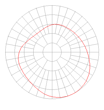 | ||||||||||||||||||
| Azimuth | Ratio | Azimuth | Ratio | Azimuth | Ratio | Azimuth | Ratio | ||||||||||||
| 0 | 0.583 | 10 | 0.600 | 20 | 0.608 | 30 | 0.610 | ||||||||||||
| 40 | 0.616 | 50 | 0.630 | 60 | 0.650 | 70 | 0.677 | ||||||||||||
| 80 | 0.712 | 90 | 0.753 | 100 | 0.801 | 110 | 0.861 | ||||||||||||
| 120 | 0.915 | 130 | 0.956 | 140 | 0.984 | 150 | 0.998 | ||||||||||||
| 155 | 1.000 | 160 | 0.998 | 170 | 0.983 | 180 | 0.954 | ||||||||||||
| 190 | 0.911 | 200 | 0.857 | 210 | 0.813 | 220 | 0.782 | ||||||||||||
| 230 | 0.761 | 240 | 0.751 | 250 | 0.747 | 260 | 0.730 | ||||||||||||
| 270 | 0.698 | 280 | 0.651 | 290 | 0.594 | 300 | 0.550 | ||||||||||||
| 310 | 0.521 | 320 | 0.508 | 325 | 0.507 | 330 | 0.511 | ||||||||||||
| 340 | 0.526 | 350 | 0.554 | ||||||||||||||||
Structure Registration Number 1057561 Structure Type: TOWER Registered To: THE BOARD OF TRUSTEES, THE UNIV. OF CT. DBA = WHUS Structure Address: 0.25 Miles North Of North Eagleville Road Storrs, CT County Name: Tolland County ASR Issued: 10/28/1998 Date Built: 04/04/2000 Site Elevation: 221 m (725 ft.) Structure Height: 99.6 m (327 ft.) Height Overall: 100.5 m (330 ft.) Overall Height AMSL: 321.5 m (1055 ft.) FAA Determination: 01/20/1994 FAA Study #: 92-ANE-270-OE FAA Circular #: 70/7460-1H Paint & Light FAA Chapters: 3, 4, 5, 13 RED LIGHTS/PAINT 41-48-50.0 N 72-15-34.0 W (NAD 83) 41-48-49.6 N 72-15-35.7 W (Converted to NAD 27) |
Board Of Trustees, Gulley Hall, 352 Mansfield Road, Unit 1048 Storrs, CT 06269 Phone: 860-486-2333 Government Entity | Date: 04/13/1999 Application Certifier THE BD. OF TRUSTEES, THE UNIV. OF CT The Bd. Of Trustees, The Univ. Of Ct Student U. Bldg Bx U-8r Storrs, CT 06269 Applicant | |||||||||||||||||
| |||||||||||||||||||