
FCCInfo.com
A Service of Cavell, Mertz & Associates, Inc.
(855) FCC-INFO
|
|
W265CG from 05/18/2011 W265CG from 12/11/2006 W265CG from 01/08/2004 |
|
|
||||||||||||||||
|
|
W265CG Channel: 265D 100.9 MHz Tuscaloosa, Alabama Service: FX - A translator or application for a translator. Facility ID: 148566 Fac. Service: FX Programming Delivery Method: Unspecified Status: License Application Accepted: 11/27/2018 Application Granted: 12/06/2018 File Number: BLFT-20181127AAN License Expires: 00/00/0000 Prefix Type: This is a license for a translator Application Type: License To Cover FCC Website Links: LMS Facility Details This Application CDBS Application Other W265CG Applications Other W265CG Applications in CDBS Including Superseded Applications Mailing Address Correspondence for W265CG Correspondence related to application BLFT-20181127AAN Service Contour - Open Street Map or USGS Map (60 dBu) Service Contour - KML / Google Earth (60 dBu) Class: D, A Noncommercial educational operating with no more than 10W Site Location: 33-09-36.4 N 87-30-54.0 W (NAD 83) Site Location: 33-09-36.0 N 87-30-54.0 W (Converted to NAD 27) Effective Radiated Power: 0.25 kW Transmitter Output Power: 0.36 kW Antenna Center HAAT: 0 m Antenna Center AMSL: 267 m (876 ft.) Antenna Center HAG: 148 m (486 ft.) Site Elevation: 119 m. (390 ft.) Height Overall*: 152 m (499 ft.) (* As Filed In This Application, may differ from ASR Data, Below.) Directional Antenna Antenna Make/Model: None Antenna ID: 129602 Polarization:
| ||||||||||||||||||
| Antenna Data for Antenna Id: 129602 W265CG FX File: BLFT-20181127AAN None - Service: FX | 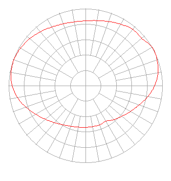 | ||||||||||||||||||
| Azimuth | Ratio | Azimuth | Ratio | Azimuth | Ratio | Azimuth | Ratio | ||||||||||||
| 0 | 0.841 | 10 | 0.857 | 20 | 0.885 | 30 | 0.919 | ||||||||||||
| 40 | 0.954 | 50 | 0.953 | 60 | 1.000 | 70 | 0.989 | ||||||||||||
| 80 | 0.957 | 90 | 0.900 | 100 | 0.822 | 110 | 0.740 | ||||||||||||
| 120 | 0.674 | 130 | 0.619 | 140 | 0.577 | 150 | 0.533 | ||||||||||||
| 160 | 0.542 | 170 | 0.540 | 180 | 0.542 | 190 | 0.547 | ||||||||||||
| 200 | 0.561 | 210 | 0.587 | 220 | 0.627 | 230 | 0.679 | ||||||||||||
| 240 | 0.744 | 250 | 0.822 | 260 | 0.898 | 270 | 0.953 | ||||||||||||
| 280 | 0.982 | 290 | 0.988 | 300 | 0.974 | 310 | 0.946 | ||||||||||||
| 320 | 0.911 | 330 | 0.877 | 340 | 0.852 | 350 | 0.840 | ||||||||||||
Structure Registration Number 1065251 [ASR Heights Differ from W265CG Application] Structure Type: GTOWER Registered To: Clearview Tower Company II, LLC Structure Address: 1700 Jug Factory Road Tuscaloosa, AL County Name: Tuscaloosa County ASR Issued: 09/11/2020 Date Built: 09/01/1984 Site Elevation: 120.7 m (396 ft.) Structure Height: 152.4 m (500 ft.) Height Overall: 152.4 m (500 ft.) Overall Height AMSL: 273.1 m (896 ft.) FAA Determination: 08/20/2020 FAA Study #: 2020-ASO-23330-OE FAA Circular #: 70/7460-1J Paint & Light FAA Chapters: 3, 4, 5, 13 OM&L to remain the same as prior studies = PAINT/RED LIGHTS 33-09-29.7 N 87-30-56.8 W (NAD 83) 33-09-29.3 N 87-30-56.8 W (Converted to NAD 27) |
1 Manhattanville Road Suite 202 Purchase, NY 10577 Phone: 203-861-0900 Limited Liability Company | Date: 11/27/2018 Application Certifier TOWNSQUARE MEDIA TUSCALOOSA LICENSE, LLC 240 Greenwich Avenue Greenwich, CT 06830 Applicant MARTIN STABBERT 240 Greenwich Avenue Greenwich, CT 06830 VICE PRESIDENT OF ENGINEERING HOWARD M. LIBERMAN Wilkinson Barker Knauer Llp 1800 M Street, N.w. Suite 800n Washington, DC 20036 | |||||||||||||||||