
FCCInfo.com
A Service of Cavell, Mertz & Associates, Inc.
(855) FCC-INFO
|
|
WXZC from 07/25/2011 WXZC from 07/22/2010 WXZC from 10/11/2000 WXZC from 05/16/1998 WXZC from 06/25/1993 WXZC from 05/28/1993 |
|
|
||||||||||||||||
|
|
WXZC Channel: 282C3 104.3 MHz Inglis, Florida Service: FM - A full-service FM station or application. Facility ID: 71585 Fac. Service: FM Status: License 73.215 Station Application Accepted: 10/29/2014 Application Granted: 11/24/2014 File Number: BLH-20141029AAS License Expires: 00/00/0000 Prefix Type: This is a license for a commercial FM station Application Type: License To Cover FCC Website Links: LMS Facility Details This Application CDBS Application Other WXZC Applications Other WXZC Applications in CDBS Including Superseded Applications Mailing Address Correspondence for WXZC Correspondence related to application BLH-20141029AAS Service Contour - Open Street Map or USGS Map (60 dBu) Service Contour - KML / Google Earth (60 dBu) Public Inspection Files Facility Type: FM STATION Class: C3, A Zone II station; with 6kW-25kW ERP and a class contour distance 28km-39km Site Location: 29-01-18.9 N 82-41-19.4 W (NAD 83) Site Location: 29-01-18.0 N 82-41-20.0 W (Converted to NAD 27) Effective Radiated Power: 19 kW Transmitter Output Power: 8.7 kW Antenna Center HAAT: 112 m (367 ft.) Antenna Center AMSL: 116.3 m (382 ft.) Antenna Center HAG: 113.3 m (372 ft.) Calculated Site Elevation: 3 m. (10 ft.) Height Overall*: 138.7 m (455 ft.) (* As Filed In This Application, may differ from ASR Data, Below.) Directional Antenna Antenna Make/Model: Jampro JMPC-4 DA, four sections Antenna ID: 106906 Polarization: | ||||||||||||||||||
| Antenna Data for Antenna Id: 106906 WXZC FM File: BLH-20141029AAS Jampro - JMPC-4 DA, four sections Service: FM | 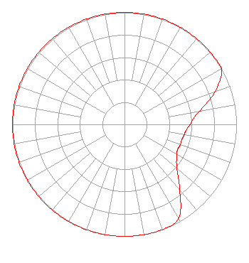 | ||||||||||||||||||
| Azimuth | Ratio | Azimuth | Ratio | Azimuth | Ratio | Azimuth | Ratio | ||||||||||||
| 0 | 1.000 | 10 | 1.000 | 20 | 1.000 | 30 | 1.000 | ||||||||||||
| 40 | 1.000 | 50 | 1.000 | 60 | 1.000 | 70 | 0.862 | ||||||||||||
| 80 | 0.685 | 85 | 0.620 | 90 | 0.585 | 95 | 0.555 | ||||||||||||
| 100 | 0.540 | 105 | 0.530 | 110 | 0.530 | 115 | 0.525 | ||||||||||||
| 120 | 0.540 | 130 | 0.610 | 140 | 0.768 | 150 | 0.967 | ||||||||||||
| 160 | 1.000 | 170 | 1.000 | 180 | 1.000 | 190 | 1.000 | ||||||||||||
| 200 | 1.000 | 210 | 1.000 | 220 | 1.000 | 230 | 1.000 | ||||||||||||
| 240 | 1.000 | 250 | 1.000 | 260 | 1.000 | 270 | 1.000 | ||||||||||||
| 280 | 1.000 | 290 | 1.000 | 300 | 1.000 | 310 | 1.000 | ||||||||||||
| 320 | 1.000 | 330 | 1.000 | 340 | 1.000 | 350 | 1.000 | ||||||||||||
Structure Registration Number 1045639 Structure Type: GTOWER Registered To: Vertical Bridge S3 Assets, LLC Structure Address: 11131 N Sun Fire Point Inglis, FL County Name: Citrus County ASR Issued: 04/02/2018 Date Built: 12/14/1999 Site Elevation: 3 m (10 ft.) Structure Height: 138.7 m (455 ft.) Height Overall: 138.7 m (455 ft.) Overall Height AMSL: 141.7 m (465 ft.) FAA Determination: 06/28/2017 FAA Study #: 2017-ASO-8684-OE FAA Circular #: 70/7460-1L Paint & Light FAA Chapters: 4, 8, 12 PRIOR STUDY 1999-ASO-529-OE 29-01-19.0 N 82-41-19.0 W (NAD 83) 29-01-18.1 N 82-41-19.6 W (Converted to NAD 27) |
13825 Us Highway 19 Suite 400 Hudson, FL 34667 Phone: 727-697-1063 Corporation | Date: 10/29/2014 Application Certifier CITRUS COUNTY ASSOCIATION FOR RETARDED CITIZENS, INC 5399 W. Gulf To Lake Highway Lecanto, FL 34461-9710 Applicant WILLIAM T. GODFREY, JR. Kessler And Gehman Associates, Inc. 507 Nw 60th Street, Suite C Gainesville, FL 32607-2055 CONSULTING ENGINEERS JERROLD MILLER Miller And Neely Pc | |||||||||||||||||
| |||||||||||||||||||