
FCCInfo.com
A Service of Cavell, Mertz & Associates, Inc.
(855) FCC-INFO
|
|
W287CO from 10/14/2015 W287CO from 01/26/2007 W287CO from 03/29/2004 |
|
|
||||||||||||||||
|
|
W287CO Channel: 287D 105.3 MHz Tallahassee, Florida Service: FX - A translator or application for a translator. Facility ID: 144674 Fac. Service: FX Programming Delivery Method: Unspecified Status: License Application Accepted: 06/28/2019 Application Granted: 07/10/2019 File Number: BMLFT-20190628AAC License Expires: 00/00/0000 Prefix Type: This is a modification of license for a translator Application Type: Minor Modification FCC Website Links: LMS Facility Details This Application CDBS Application Other W287CO Applications Other W287CO Applications in CDBS Including Superseded Applications Mailing Address Correspondence for W287CO Correspondence related to application BMLFT-20190628AAC Service Contour - Open Street Map or USGS Map (60 dBu) Service Contour - KML / Google Earth (60 dBu) Class: D, A Noncommercial educational operating with no more than 10W Site Location: 30-29-33.1 N 84-17-12.7 W (NAD 83) Site Location: 30-29-32.4 N 84-17-13.1 W (Converted to NAD 27) Effective Radiated Power: 0.22 kW Transmitter Output Power: 0.81 kW Antenna Center HAAT: 0 m Antenna Center AMSL: 210 m (689 ft.) Antenna Center HAG: 144 m (472 ft.) Site Elevation: 66 m. (217 ft.) Height Overall*: 146 m (479 ft.) (* As Filed In This Application, may differ from ASR Data, Below.) Directional Antenna Antenna Make/Model: None Antenna ID: 122235 Polarization:
| ||||||||||||||||||
| Antenna Data for Antenna Id: 122235 W287CO FX File: BMLFT-20190628AAC None - Service: FX | 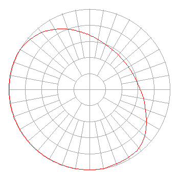 | ||||||||||||||||||
| Azimuth | Ratio | Azimuth | Ratio | Azimuth | Ratio | Azimuth | Ratio | ||||||||||||
| 0 | 0.676 | 10 | 0.628 | 20 | 0.594 | 30 | 0.571 | ||||||||||||
| 40 | 0.558 | 50 | 0.553 | 60 | 0.558 | 70 | 0.571 | ||||||||||||
| 80 | 0.594 | 90 | 0.628 | 100 | 0.682 | 110 | 0.738 | ||||||||||||
| 120 | 0.815 | 130 | 0.897 | 140 | 0.953 | 150 | 0.973 | ||||||||||||
| 160 | 0.983 | 170 | 1.000 | 180 | 1.000 | 190 | 1.000 | ||||||||||||
| 200 | 1.000 | 210 | 1.000 | 220 | 1.000 | 230 | 1.000 | ||||||||||||
| 240 | 1.000 | 250 | 1.000 | 260 | 1.000 | 270 | 1.000 | ||||||||||||
| 280 | 1.000 | 290 | 1.000 | 300 | 0.991 | 310 | 0.963 | ||||||||||||
| 320 | 0.923 | 330 | 0.862 | 340 | 0.797 | 350 | 0.731 | ||||||||||||
Structure Registration Number 1030925 Structure Type: GTOWER Registered To: Crown Castle South LLC Structure Address: Twr 1 - 123 Ridgeland Rd Tallahassee, FL County Name: Leon County ASR Issued: 05/06/2016 Date Built: 12/23/2008 Site Elevation: 65.8 m (216 ft.) Structure Height: 145.7 m (478 ft.) Height Overall: 145.9 m (479 ft.) Overall Height AMSL: 211.7 m (695 ft.) FAA Determination: 02/05/2009 FAA Study #: 2009-ASO-525-OE FAA Circular #: 70/7460-1K Paint & Light FAA Chapters: 4, 8, 12 PRIOR STUDY 2008-ASO-5385-OE 30-29-33.1 N 84-17-12.7 W (NAD 83) 30-29-32.4 N 84-17-13.1 W (Converted to NAD 27) |
7136 S. Yale Avenue Tulsa, OK 74136 Phone: 918-664-4581 | Date: 06/28/2019 Application Certifier CLEAR CHANNEL BROADCASTING LICENSES, INC. 7136 S. Yale Avenue Suite 501 Tulsa, OK 74136 Applicant RANDALL L. MULLINAX 2859 Cascade Dr. Gainesville, GA 30504 REGIONAL ENGINEER CLEAR CHANNEL BROADCASTING LICENSES, INC. Clear Channel Broadcasting Licenses, Inc. 7136 S. Yale Avenue Suite 501 Tulsa, OK 74136 | |||||||||||||||||