
FCCInfo.com
A Service of Cavell, Mertz & Associates, Inc.
(855) FCC-INFO
|
|
W241DH from 03/17/1997 |
|
|
||||||||||||||||
|
|
W241DH Channel: 241D 96.1 MHz Bradenton, Florida Service: FX - A translator or application for a translator. Facility ID: 83547 Fac. Service: FX Programming Delivery Method: Unspecified Status: License (Licensed And Silent) Application Accepted: 07/18/2019 Application Granted: 07/29/2019 File Number: BLFT-20190718AAD License Expires: 00/00/0000 Prefix Type: This is a license for a translator Application Type: License To Cover FCC Website Links: LMS Facility Details This Application CDBS Application Other W241DH Applications Other W241DH Applications in CDBS Including Superseded Applications Mailing Address Correspondence for W241DH Correspondence related to application BLFT-20190718AAD Service Contour - Open Street Map or USGS Map (60 dBu) Service Contour - KML / Google Earth (60 dBu) Class: D, A Noncommercial educational operating with no more than 10W Site Location: 27-32-43.1 N 82-34-26.3 W (NAD 83) Site Location: 27-32-42.0 N 82-34-27.0 W (Converted to NAD 27) Effective Radiated Power: 0.1 kW Transmitter Output Power: 0.103 kW Antenna Center HAAT: 0 m Antenna Center AMSL: 115 m (377 ft.) Antenna Center HAG: 112 m (367 ft.) Site Elevation: 3 m. (10 ft.) Height Overall*: 186 m (610 ft.) (* As Filed In This Application, may differ from ASR Data, Below.) Directional Antenna Antenna Make/Model: None Antenna ID: 135028 Polarization:
| ||||||||||||||||||
| Antenna Data for Antenna Id: 135028 W241DH FX File: BLFT-20190718AAD None - Service: FX | 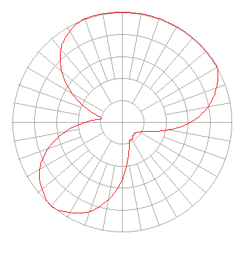 | ||||||||||||||||||
| Azimuth | Ratio | Azimuth | Ratio | Azimuth | Ratio | Azimuth | Ratio | ||||||||||||
| 0 | 1.000 | 10 | 1.000 | 20 | 1.000 | 30 | 1.000 | ||||||||||||
| 40 | 1.000 | 50 | 1.000 | 60 | 1.000 | 70 | 0.915 | ||||||||||||
| 80 | 0.796 | 90 | 0.628 | 100 | 0.423 | 110 | 0.247 | ||||||||||||
| 120 | 0.181 | 130 | 0.157 | 140 | 0.160 | 150 | 0.182 | ||||||||||||
| 160 | 0.193 | 170 | 0.329 | 180 | 0.528 | 190 | 0.718 | ||||||||||||
| 200 | 0.866 | 210 | 0.952 | 220 | 1.000 | 230 | 0.952 | ||||||||||||
| 240 | 0.866 | 250 | 0.718 | 260 | 0.528 | 270 | 0.329 | ||||||||||||
| 280 | 0.190 | 290 | 0.329 | 300 | 0.528 | 310 | 0.718 | ||||||||||||
| 320 | 0.866 | 330 | 0.952 | 340 | 1.000 | 350 | 1.000 | ||||||||||||
Structure Registration Number 1034035 Structure Type: GTOWER Registered To: Vertical Bridge CC FM, LLC Structure Address: 900 33rd Street West (us-fl-5031) Palmetto, FL County Name: Manatee County ASR Issued: 04/05/2022 Date Built: 05/01/1999 Site Elevation: 3 m (10 ft.) Structure Height: 184.7 m (606 ft.) Height Overall: 185.6 m (609 ft.) Overall Height AMSL: 188.6 m (619 ft.) FAA Determination: 03/17/2022 FAA Study #: 2022-ASO-5370-OE FAA Circular #: 70/7460-1M Paint & Light FAA Chapters: 4, 8, 15 PRIOR STUDY 2014-ASO-1113-OE 27-32-42.9 N 82-34-26.8 W (NAD 83) 27-32-41.8 N 82-34-27.5 W (Converted to NAD 27) |
3113 Stirling Road Suite 103 Ft. Lauderdale, FL 33313 Phone: 202-747-1694 Corporation | Date: 07/18/2019 Application Certifier POLNET COMMUNICATIONS, LTD. 3656 West Belmont Ave. Chicago, IL 60618 Applicant CHARLES M. ANDERSON 1519 Euclid Avenue Bowling Green, KY 42103 ENGINEERING CONSULTANT JOAN STEWART Wiley Rein Llp 1776 K Street, Nw Washington, DC 20006 | |||||||||||||||||