
FCCInfo.com
A Service of Cavell, Mertz & Associates, Inc.
(855) FCC-INFO
|
|
|
|
|
||||||||||||||||
|
|
W292EL Channel: 292D 106.3 MHz Memphis, Tennessee Service: FX - A translator or application for a translator. Facility ID: 155668 Fac. Service: FX Programming Delivery Method: Unspecified Status: License Application Accepted: 12/16/2016 Application Granted: 12/22/2016 File Number: BLFT-20161216ABS License Expires: 00/00/0000 Prefix Type: This is a license for a translator Application Type: License To Cover FCC Website Links: LMS Facility Details This Application CDBS Application Other W292EL Applications Other W292EL Applications in CDBS Including Superseded Applications Mailing Address Correspondence for W292EL Correspondence related to application BLFT-20161216ABS Service Contour - Open Street Map or USGS Map (60 dBu) Service Contour - KML / Google Earth (60 dBu) Class: D, A Noncommercial educational operating with no more than 10W Site Location: 35-10-29.3 N 89-50-43.3 W (NAD 83) Site Location: 35-10-29.0 N 89-50-43.0 W (Converted to NAD 27) Effective Radiated Power: 0.25 kW Transmitter Output Power: 0.517 kW Antenna Center HAAT: 0 m Antenna Center AMSL: 276 m (906 ft.) Antenna Center HAG: 198 m (650 ft.) Site Elevation: 78 m. (256 ft.) Height Overall*: 326 m (1070 ft.) (* As Filed In This Application, may differ from ASR Data, Below.) Directional Antenna Antenna Make/Model: None Antenna ID: 124551 Polarization:
| ||||||||||||||||||
| Antenna Data for Antenna Id: 124551 W292EL FX File: BLFT-20161216ABS None - Service: FX | 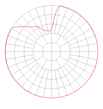 | ||||||||||||||||||
| Azimuth | Ratio | Azimuth | Ratio | Azimuth | Ratio | Azimuth | Ratio | ||||||||||||
| 0 | 0.487 | 10 | 1.000 | 20 | 1.000 | 30 | 1.000 | ||||||||||||
| 40 | 1.000 | 50 | 1.000 | 60 | 1.000 | 70 | 1.000 | ||||||||||||
| 80 | 1.000 | 90 | 1.000 | 100 | 1.000 | 110 | 1.000 | ||||||||||||
| 120 | 1.000 | 130 | 1.000 | 140 | 1.000 | 150 | 1.000 | ||||||||||||
| 160 | 1.000 | 170 | 1.000 | 180 | 1.000 | 190 | 1.000 | ||||||||||||
| 200 | 1.000 | 210 | 1.000 | 220 | 1.000 | 230 | 1.000 | ||||||||||||
| 240 | 1.000 | 250 | 1.000 | 260 | 1.000 | 270 | 1.000 | ||||||||||||
| 280 | 1.000 | 290 | 1.000 | 300 | 1.000 | 310 | 0.832 | ||||||||||||
| 320 | 0.692 | 330 | 0.622 | 340 | 0.489 | 350 | 0.463 | ||||||||||||
Structure Registration Number 1039554 Structure Type: GTOWER Registered To: American Towers LLC Structure Address: 6555 Raleigh La Grange Rd (#207708) Memphis, TN County Name: Shelby County ASR Issued: 07/10/2021 Date Built: 11/18/2010 Site Elevation: 78 m (256 ft.) Structure Height: 306.5 m (1006 ft.) Height Overall: 325.8 m (1069 ft.) Overall Height AMSL: 403.8 m (1325 ft.) FAA Determination: 07/08/2021 FAA Study #: 2021-ASO-24772-OE FAA Circular #: 70/7460-1M Paint & Light FAA Chapters: 4, 9, 15 PRIOR STUDY 2017-ASO-18906-OE 35-10-29.0 N 89-50-43.0 W (NAD 83) 35-10-28.7 N 89-50-42.7 W (Converted to NAD 27) |
4111 Plains Blvd. Amarillo, TX 79106 Phone: 208-733-3551 | Date: 12/16/2016 Application Certifier EDGEWATER BROADCASTING, INC. 160 W Gooding Street Twin Falls, ID 83301 Applicant GENE WISNIEWSKI 160 Gooding Street West Suite A Twin Falls, ID 83301 CONSULTING ENGINEER CLARK PARRISH Edgewater Broadcasting, Inc. 160 W Gooding Street Twin Falls, ID 83301 | |||||||||||||||||