
FCCInfo.com
A Service of Cavell, Mertz & Associates, Inc.
(855) FCC-INFO
|
|
K268DA from 01/08/2004 |
|
|
||||||||||||||||
|
|
K268DA Channel: 268D 101.5 MHz Memphis, Tennessee Service: FX - A translator or application for a translator. Facility ID: 148303 Fac. Service: FX Programming Delivery Method: Unspecified Status: License Application Accepted: 12/23/2016 Application Granted: 03/01/2017 File Number: BLFT-20161223AAY License Expires: 00/00/0000 Prefix Type: This is a license for a translator Application Type: License To Cover FCC Website Links: LMS Facility Details This Application CDBS Application Other K268DA Applications Other K268DA Applications in CDBS Including Superseded Applications Mailing Address Correspondence for K268DA Correspondence related to application BLFT-20161223AAY Service Contour - Open Street Map or USGS Map (60 dBu) Service Contour - KML / Google Earth (60 dBu) Class: D, A Noncommercial educational operating with no more than 10W Site Location: 35-08-31.3 N 90-08-06.3 W (NAD 83) Site Location: 35-08-31.0 N 90-08-06.0 W (Converted to NAD 27) Effective Radiated Power: 0.25 kW Transmitter Output Power: 0.576 kW Antenna Center HAAT: 0 m Antenna Center AMSL: 134 m (440 ft.) Antenna Center HAG: 68 m (223 ft.) Site Elevation: 66 m. (217 ft.) Height Overall*: 70 m (230 ft.) (* As Filed In This Application, may differ from ASR Data, Below.) Directional Antenna Antenna Make/Model: None Antenna ID: 124002 Polarization:
| ||||||||||||||||||
| Antenna Data for Antenna Id: 124002 K268DA FX File: BLFT-20161223AAY None - Service: FX Pattern and Field Values Include a 100° Clockwise Rotation | 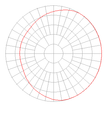 | ||||||||||||||||||
| Azimuth | Ratio | Azimuth | Ratio | Azimuth | Ratio | Azimuth | Ratio | ||||||||||||
| 0 | 0.872 | 10 | 0.913 | 20 | 0.957 | 30 | 0.988 | ||||||||||||
| 40 | 0.998 | 50 | 1.000 | 60 | 1.000 | 70 | 1.000 | ||||||||||||
| 80 | 1.000 | 90 | 1.000 | 100 | 1.000 | 110 | 1.000 | ||||||||||||
| 120 | 1.000 | 130 | 1.000 | 140 | 1.000 | 150 | 1.000 | ||||||||||||
| 160 | 0.998 | 170 | 0.988 | 180 | 0.957 | 190 | 0.913 | ||||||||||||
| 200 | 0.872 | 210 | 0.832 | 220 | 0.791 | 230 | 0.755 | ||||||||||||
| 240 | 0.721 | 250 | 0.705 | 260 | 0.701 | 270 | 0.701 | ||||||||||||
| 280 | 0.701 | 290 | 0.701 | 300 | 0.701 | 310 | 0.705 | ||||||||||||
| 320 | 0.721 | 330 | 0.755 | 340 | 0.791 | 350 | 0.832 | ||||||||||||
Structure Registration Number 1035168 [ASR Heights Differ from K268DA Application] Structure Type: Registered To: Butron Media Corporation Structure Address: Twr 1 102 North Fifth Street West Memphis, AR County Name: Crittenden County ASR Issued: 10/29/2018 Date Built: 01/07/1961 Site Elevation: 65.5 m (215 ft.) Structure Height: 69.6 m (228 ft.) Height Overall: 70.4 m (231 ft.) Overall Height AMSL: 135.9 m (446 ft.) Paint & Light FAA Chapters: 1, 3, 11, 21 35-08-31.0 N 90-08-06.0 W (NAD 83) 35-08-30.7 N 90-08-05.7 W (Converted to NAD 27) |
3654 Park Ave Memphis, TN 38111 Phone: 615-400-2000 Corporation | Date: 12/23/2016 Application Certifier FIRST VENTURES CAPITAL PARTNERS, INC. 4516 Lovers Lane Suite 288 Dallas, TX 75225 Applicant GEORGE MICHAEL PATTON 12231 Industriplex Blvd Suite C Baton Rouge, LA 70809 CONSULTING ENGINEER KERRY RHODES First Ventures Capital Partners, Inc. 4516 Lovers Lane Suite 288 Dallas, TX 75225 | |||||||||||||||||