
FCCInfo.com
A Service of Cavell, Mertz & Associates, Inc.
(855) FCC-INFO
|
|
WRVX from 07/07/2008 |
|  |
|
|||||||||||||||
|
|
WRVX Channel: 219C2 91.7 MHz Cameron, Missouri Service: FM - A full-service FM station or application. Facility ID: 172360 Fac. Service: FM Status: License 73.215 Station Application Accepted: 11/06/2012 Application Granted: 02/07/2013 File Number: BLED-20121106ACT License Expires: 00/00/0000 Prefix Type: This is a license for a noncommercial educational FM station Application Type: Amendment FCC Website Links: LMS Facility Details This Application CDBS Application Other WRVX Applications Other WRVX Applications in CDBS Including Superseded Applications Mailing Address Correspondence for WRVX Correspondence related to application BLED-20121106ACT Service Contour - Open Street Map or USGS Map (60 dBu) Service Contour - KML / Google Earth (60 dBu) Public Inspection Files Facility Type: NON-COMMERCIAL EDUC. FM Class: C2, A Zone II station; with 25kW-50kW ERP and a class contour distance 39km-52km Site Location: 39-57-36.0 N 94-07-08.8 W (NAD 83) Site Location: 39-57-36.0 N 94-07-08.0 W (Converted to NAD 27) Effective Radiated Power: 27.5 kW Transmitter Output Power: 5.551 kW Antenna Center HAAT: 116 m (381 ft.) Antenna Center AMSL: 381 m (1250 ft.) Antenna Center HAG: 80 m (262 ft.) Calculated Site Elevation: 301 m. (988 ft.) Height Overall*: 91 m (299 ft.) (* As Filed In This Application, may differ from ASR Data, Below.) Directional Antenna Antenna Make/Model: Propagation System Inc FMR-6-DA, six sections Antenna ID: 109241 Polarization:
| ||||||||||||||||||
| Antenna Data for Antenna Id: 109241 WRVX FM File: BLED-20121106ACT Propagation System Inc - FMR-6-DA, six sections Service: FM | 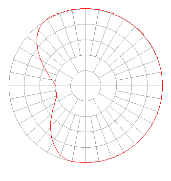 | ||||||||||||||||||
| Azimuth | Ratio | Azimuth | Ratio | Azimuth | Ratio | Azimuth | Ratio | ||||||||||||
| 0 | 1.000 | 10 | 1.000 | 20 | 1.000 | 30 | 1.000 | ||||||||||||
| 40 | 1.000 | 50 | 1.000 | 60 | 1.000 | 70 | 1.000 | ||||||||||||
| 80 | 1.000 | 90 | 1.000 | 100 | 1.000 | 110 | 1.000 | ||||||||||||
| 120 | 1.000 | 130 | 1.000 | 140 | 1.000 | 150 | 1.000 | ||||||||||||
| 160 | 1.000 | 170 | 1.000 | 180 | 1.000 | 190 | 1.000 | ||||||||||||
| 200 | 0.955 | 210 | 0.846 | 220 | 0.706 | 230 | 0.568 | ||||||||||||
| 240 | 0.465 | 250 | 0.402 | 260 | 0.389 | 270 | 0.389 | ||||||||||||
| 280 | 0.445 | 290 | 0.543 | 300 | 0.671 | 310 | 0.821 | ||||||||||||
| 320 | 0.946 | 330 | 1.000 | 340 | 1.000 | 350 | 1.000 | ||||||||||||
Structure Registration Number 1283749 Structure Type: GTOWER Registered To: VCY America, Inc Structure Address: The Tower Is 902 Feet From The Intersection Of Major Ave And Hwy 69 At 262 Degre Cameron, MO County Name: Daviess County ASR Issued: 10/02/2012 Date Built: 09/27/2012 Site Elevation: 301 m (988 ft.) Structure Height: 91.4 m (300 ft.) Height Overall: 91.4 m (300 ft.) Overall Height AMSL: 392.4 m (1287 ft.) FAA Determination: 10/01/2012 FAA Study #: 2012-ACE-3107-OE FAA Circular #: 70/7460-1K Paint & Light FAA Chapters: 3, 4, 5, 12 PRIOR STUDY 2012-ACE-909-OE 39-57-36.0 N 94-07-09.0 W (NAD 83) 39-57-36.0 N 94-07-08.2 W (Converted to NAD 27) |
3434 W. Kilbourn Ave Milwaukee, WI 52308 Phone: 414-935-3000 Not-for-Profit | Date: 11/06/2012 Application Certifier VCY AMERICA, INC. 3434 W. Kilbourn Ave Milwaukee, WI 53208-3313 Applicant JAMES E. PRICE, III Sterling Communications, Inc. 219 Dodd Rd. Ringgold, GA 30736-2958 TECHNICAL CONSULTANT JAMES E. PRICE, III Sterling Communications, Inc. | |||||||||||||||||