
FCCInfo.com
A Service of Cavell, Mertz & Associates, Inc.
(855) FCC-INFO
|
|
W230CM from 09/25/2013 |
|
|
||||||||||||||||
|
|
W230CM Channel: 230D 93.9 MHz Poughkeepsie, New York Service: FX - A translator or application for a translator. Facility ID: 157070 Fac. Service: FX Programming Delivery Method: Unspecified Status: License Application Accepted: 12/11/2017 Application Granted: 12/27/2017 File Number: BLFT-20171211AAX License Expires: 00/00/0000 Prefix Type: This is a license for a translator Application Type: License To Cover FCC Website Links: LMS Facility Details This Application CDBS Application Other W230CM Applications Other W230CM Applications in CDBS Including Superseded Applications Mailing Address Correspondence for W230CM Correspondence related to application BLFT-20171211AAX Service Contour - Open Street Map or USGS Map (60 dBu) Service Contour - KML / Google Earth (60 dBu) Class: D, A Noncommercial educational operating with no more than 10W Site Location: 41-53-44.3 N 73-59-32.5 W (NAD 83) Site Location: 41-53-44.0 N 73-59-34.0 W (Converted to NAD 27) Effective Radiated Power: 0.15 kW Transmitter Output Power: 0.301 kW Antenna Center HAAT: 0 m Antenna Center AMSL: 232 m (761 ft.) Antenna Center HAG: 31 m (102 ft.) Site Elevation: 201 m. (659 ft.) Height Overall*: 61 m (200 ft.) (* As Filed In This Application, may differ from ASR Data, Below.) Directional Antenna Antenna Make/Model: None Antenna ID: 128022 Polarization:
| ||||||||||||||||||
| Antenna Data for Antenna Id: 128022 W230CM FX File: BLFT-20171211AAX None - Service: FX | 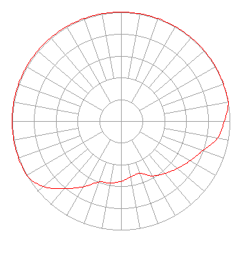 | ||||||||||||||||||
| Azimuth | Ratio | Azimuth | Ratio | Azimuth | Ratio | Azimuth | Ratio | ||||||||||||
| 0 | 1.000 | 10 | 1.000 | 20 | 1.000 | 30 | 1.000 | ||||||||||||
| 40 | 1.000 | 50 | 1.000 | 60 | 1.000 | 70 | 1.000 | ||||||||||||
| 80 | 1.000 | 90 | 0.949 | 100 | 0.901 | 110 | 0.797 | ||||||||||||
| 120 | 0.731 | 130 | 0.676 | 140 | 0.628 | 150 | 0.580 | ||||||||||||
| 160 | 0.510 | 170 | 0.520 | 180 | 0.553 | 190 | 0.578 | ||||||||||||
| 200 | 0.596 | 210 | 0.697 | 220 | 0.808 | 230 | 0.933 | ||||||||||||
| 240 | 1.000 | 250 | 1.000 | 260 | 1.000 | 270 | 1.000 | ||||||||||||
| 280 | 1.000 | 290 | 1.000 | 300 | 1.000 | 310 | 1.000 | ||||||||||||
| 320 | 1.000 | 330 | 1.000 | 340 | 1.000 | 350 | 1.000 | ||||||||||||
Structure Registration Number 1002670 Structure Type: TOWER Registered To: HISTORIC HUDSON VALLEY RADIO INC Structure Address: Snake Hill Station Rd Port Ewen, NY County Name: Ulster County ASR Issued: 09/30/2004 Date Built: 12/01/1988 Site Elevation: 201 m (659 ft.) Structure Height: 60.7 m (199 ft.) Height Overall: 60.7 m (199 ft.) Overall Height AMSL: 261.7 m (859 ft.) FAA Determination: 05/11/2000 FAA Study #: 00-AEA-1175-OE Paint & Light FAA Chapters: NONE PRIOR FAA 96-AEA-1831-OE 41-53-44.0 N 73-59-32.0 W (NAD 83) 41-53-43.7 N 73-59-33.5 W (Converted to NAD 27) |
Digital Radio Broadcasting, Inc. Po Box 920 15 Neversink Drive Port Jervis, NY 12771 Phone: 845-858-9100 | Date: 12/11/2017 Application Certifier CHARLES WILLIAMSON Digital Radio Broadcasting, Inc. Po Box 920 15 Neversink Drive Port Jervis, NY 12771 Applicant CHARLES WILLIAMSON Digital Radio Engineering, Inc. Po Box 920 15 Neversink Drive Port Jervis, NY 12771 APPLICANT DAVID G. O'NEIL, ESQ. Rini Coran, Pc 1140 19th Street, Nw Suite 600 Washington, DC 20036 | |||||||||||||||||