
FCCInfo.com
A Service of Cavell, Mertz & Associates, Inc.
(855) FCC-INFO
|
|
WLTY from 08/01/1991 WLTY from 02/15/1988 WLTY from 10/03/1986 |
|
|
||||||||||||||||
|
|
WLTY Channel: 244C3 96.7 MHz Cayce, South Carolina Service: FM - A full-service FM station or application. Facility ID: 4667 Fac. Service: FM Analog & Digital Status: License 73.215 Station Application Accepted: 09/02/2005 Application Granted: 09/14/2005 File Number: BLH-20050902ABZ License Expires: 00/00/0000 Prefix Type: This is a license for a commercial FM station Application Type: Amendment FCC Website Links: LMS Facility Details This Application CDBS Application Other WLTY Applications Other WLTY Applications in CDBS Including Superseded Applications Mailing Address Correspondence for WLTY Correspondence related to application BLH-20050902ABZ Service Contour - Open Street Map or USGS Map (60 dBu) Service Contour - KML / Google Earth (60 dBu) Public Inspection Files History Cards for WLTY Facility Type: FM STATION Class: C3, A Zone II station; with 6kW-25kW ERP and a class contour distance 28km-39km Site Location: 34-00-18.6 N 81-00-43.3 W (NAD 83) Site Location: 34-00-18.0 N 81-00-44.0 W (Converted to NAD 27) Effective Radiated Power: 9 kW Transmitter Output Power: 4.1 kW Antenna Center HAAT: 132 m (433 ft.) Antenna Center AMSL: 199 m (653 ft.) Antenna Center HAG: 126 m (413 ft.) Calculated Site Elevation: 73 m. (240 ft.) Height Overall*: 135 m (443 ft.) (* As Filed In This Application, may differ from ASR Data, Below.) Directional Antenna Antenna Make/Model: DIELECTRIC DCRH6E5RD Antenna ID: 68418 Polarization:
| ||||||||||||||||||
| Antenna Data for Antenna Id: 68418 WLTY FM File: BLH-20050902ABZ DIELECTRIC - DCRH6E5RD Service: FM | 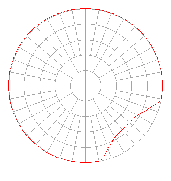 | ||||||||||||||||||
| Azimuth | Ratio | Azimuth | Ratio | Azimuth | Ratio | Azimuth | Ratio | ||||||||||||
| 0 | 1.000 | 10 | 1.000 | 20 | 1.000 | 30 | 1.000 | ||||||||||||
| 40 | 1.000 | 50 | 1.000 | 60 | 1.000 | 70 | 1.000 | ||||||||||||
| 80 | 1.000 | 90 | 1.000 | 100 | 1.000 | 110 | 0.871 | ||||||||||||
| 120 | 0.778 | 130 | 0.743 | 140 | 0.744 | 150 | 0.774 | ||||||||||||
| 160 | 0.866 | 170 | 1.000 | 180 | 1.000 | 190 | 1.000 | ||||||||||||
| 200 | 1.000 | 210 | 1.000 | 220 | 1.000 | 230 | 1.000 | ||||||||||||
| 240 | 1.000 | 250 | 1.000 | 260 | 1.000 | 270 | 1.000 | ||||||||||||
| 280 | 1.000 | 290 | 1.000 | 300 | 1.000 | 310 | 1.000 | ||||||||||||
| 320 | 1.000 | 330 | 1.000 | 340 | 1.000 | 350 | 1.000 | ||||||||||||
Structure Registration Number 1053747 Structure Type: GTOWER Registered To: Vertical Bridge CC FM, LLC Structure Address: 2440 Millwood Ave Columbia, SC County Name: Richland County ASR Issued: 12/19/2018 Date Built: 01/01/1939 Site Elevation: 73.2 m (240 ft.) Structure Height: 135 m (443 ft.) Height Overall: 135 m (443 ft.) Overall Height AMSL: 208.2 m (683 ft.) FAA Determination: 09/25/2015 FAA Study #: 2015-ASO-15435-OE FAA Circular #: 70/7460-1K Paint & Light FAA Chapters: 4, 8, 12 FAA CHAPTERS 4,8,12; 70-7460-1K WITH BIRD LIGHTING DEVIATION SPECIAL CONDITION. 34-00-19.0 N 81-00-43.0 W (NAD 83) 34-00-18.4 N 81-00-43.7 W (Converted to NAD 27) |
7136 S. Yale Avenue Suite 501 Tulsa, OK 74136 Phone: 918-664-4581 Limited Liability Company | Date: 09/02/2005 Application Certifier CAPSTAR TX LIMITED PARTNERSHIP 2625 S. Memorial Drive Suite A Tulsa, OK 74129 Applicant JEFFREY G. FREY 2625 S Memorial Drive Suite A Tulsa, OK 74129 FCC ENGINEER MARISSA G. REPP Hogan & Hartson Llp | |||||||||||||||||
|
| ||||||||||||||||||