
FCCInfo.com
A Service of Cavell, Mertz & Associates, Inc.
(855) FCC-INFO
|
|
|
|  |
|
|||||||||||||||
|
|
WVSS Channel: 214A 90.7 MHz Menomonie, Wisconsin Service: FM - A full-service FM station or application. Facility ID: 4287 Fac. Service: FM Status: License Application Accepted: 09/03/2002 Application Granted: 09/27/2002 File Number: BLED-20020903AFN License Expires: 00/00/0000 Prefix Type: This is a license for a noncommercial educational FM station Application Type: Amendment FCC Website Links: LMS Facility Details This Application CDBS Application Other WVSS Applications Other WVSS Applications in CDBS Including Superseded Applications Mailing Address Correspondence for WVSS Correspondence related to application BLED-20020903AFN Service Contour - Open Street Map or USGS Map (60 dBu) Service Contour - KML / Google Earth (60 dBu) Public Inspection Files History Cards for WVSS Facility Type: NON-COMMERCIAL EDUC. FM Class: A, A Zone I; I-A; or II station; with 0.1kW-6kW ERP and a class contour distance <=28km Site Location: 44-54-55.9 N 92-04-34.7 W (NAD 83) Site Location: 44-54-56.0 N 92-04-34.0 W (Converted to NAD 27) Effective Radiated Power: 0.59 kW Transmitter Output Power: 0.9 kW Antenna Center HAAT: 130 m (427 ft.) Antenna Center AMSL: 449 m (1473 ft.) Antenna Center HAG: 89.3 m (293 ft.) Site Elevation: 359.7 m. (1180 ft.) Height Overall*: 97.5 m (320 ft.) (* As Filed In This Application, may differ from ASR Data, Below.) Directional Antenna Antenna Make/Model: None Shively 6810-1D-DA, one section Antenna ID: 42828 Polarization: | ||||||||||||||||||
| Antenna Data for Antenna Id: 42828 WVSS FM File: BLED-20020903AFN None - Shively 6810-1D-DA, one section Service: FM Pattern and Field Values Include a 335° Clockwise Rotation | 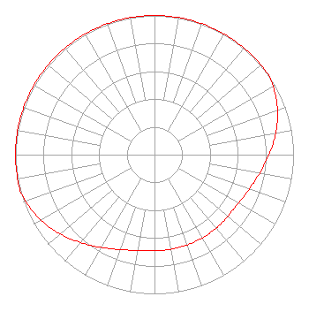 | ||||||||||||||||||
| Azimuth | Ratio | Azimuth | Ratio | Azimuth | Ratio | Azimuth | Ratio | ||||||||||||
| 5 | 1.000 | 15 | 1.000 | 25 | 1.000 | 35 | 1.000 | ||||||||||||
| 45 | 1.000 | 55 | 1.000 | 65 | 0.965 | 75 | 0.915 | ||||||||||||
| 85 | 0.855 | 95 | 0.795 | 105 | 0.745 | 115 | 0.710 | ||||||||||||
| 125 | 0.690 | 135 | 0.690 | 145 | 0.690 | 155 | 0.690 | ||||||||||||
| 165 | 0.690 | 175 | 0.690 | 185 | 0.690 | 195 | 0.710 | ||||||||||||
| 205 | 0.745 | 215 | 0.795 | 225 | 0.855 | 235 | 0.915 | ||||||||||||
| 245 | 0.965 | 255 | 1.000 | 265 | 1.000 | 275 | 1.000 | ||||||||||||
| 285 | 1.000 | 295 | 1.000 | 305 | 1.000 | 315 | 1.000 | ||||||||||||
| 325 | 1.000 | 335 | 1.000 | 345 | 1.000 | 355 | 1.000 | ||||||||||||
Structure Registration Number 1202752 Structure Type: GTOWER Registered To: Global Signal Acquisitions LLC Structure Address: 640th Avenue Lucas Township Knapp, WI County Name: Dunn County ASR Issued: 05/05/2016 Date Built: 08/18/2013 Site Elevation: 359.7 m (1180 ft.) Structure Height: 91.7 m (301 ft.) Height Overall: 97.5 m (320 ft.) Overall Height AMSL: 457.2 m (1500 ft.) FAA Determination: 06/26/2013 FAA Study #: 2013-AGL-6146-OE FAA Circular #: 70/7460-1K Paint & Light FAA Chapters: 4, 8, 12 PRIOR STUDY 2004-AGL-5671-OE 44-54-55.9 N 92-04-34.6 W (NAD 83) 44-54-56.0 N 92-04-33.9 W (Converted to NAD 27) |
1860 Van Hise Hall 1220 Linden Drive Madison, WI 53706 Phone: 608-262-2326 Government Entity | Date: 09/03/2002 Application Certifier BOARD OF REGENTS OF THE UNIVERSITY OF WISCONSIN SYSTEM 1730 Van Hise Hall 1220 Linden Dr. Madison, WI 53706 Applicant ALLEN J. RIELAND 7166 Vilas Hall 821 University Ave. Madison, WI 53706 UW-EXTENSION EMPLOYEE MARGARET L. MILLER Dow, Lohnes & Albertson | |||||||||||||||||
| |||||||||||||||||||