
FCCInfo.com
A Service of Cavell, Mertz & Associates, Inc.
(855) FCC-INFO
|
|
K223CO from 01/13/2014 |
|
|
||||||||||||||||
|
|
K223CO Channel: 223D 92.5 MHz Tremonton, Utah Service: FX - A translator or application for a translator. Facility ID: 146395 Fac. Service: FX Programming Delivery Method: Unspecified Status: License Application Accepted: 03/15/2018 Application Granted: 04/04/2018 File Number: BLFT-20180315AAL License Expires: 00/00/0000 Prefix Type: This is a license for a translator Application Type: License To Cover FCC Website Links: LMS Facility Details This Application CDBS Application Other K223CO Applications Other K223CO Applications in CDBS Including Superseded Applications Mailing Address Correspondence for K223CO Correspondence related to application BLFT-20180315AAL Service Contour - Open Street Map or USGS Map (60 dBu) Service Contour - KML / Google Earth (60 dBu) Class: D, A Noncommercial educational operating with no more than 10W Site Location: 41-44-53.7 N 112-13-39.8 W (NAD 83) Site Location: 41-44-54.0 N 112-13-37.0 W (Converted to NAD 27) Effective Radiated Power: 0.048 kW Transmitter Output Power: 0.124 kW Antenna Center HAAT: 0 m Antenna Center AMSL: 1780 m (5840 ft.) Antenna Center HAG: 40 m (131 ft.) Site Elevation: 1740 m. (5709 ft.) Height Overall*: 91 m (299 ft.) (* As Filed In This Application, may differ from ASR Data, Below.) Directional Antenna Antenna Make/Model: None Antenna ID: 129697 Polarization:
| ||||||||||||||||||
| Antenna Data for Antenna Id: 129697 K223CO FX File: BLFT-20180315AAL None - Service: FX Pattern and Field Values Include a 350° Clockwise Rotation | 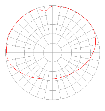 | ||||||||||||||||||
| Azimuth | Ratio | Azimuth | Ratio | Azimuth | Ratio | Azimuth | Ratio | ||||||||||||
| 0 | 0.983 | 10 | 0.983 | 20 | 0.988 | 30 | 0.988 | ||||||||||||
| 40 | 0.992 | 50 | 1.000 | 60 | 0.991 | 70 | 0.963 | ||||||||||||
| 80 | 0.923 | 90 | 0.862 | 100 | 0.797 | 110 | 0.731 | ||||||||||||
| 120 | 0.676 | 130 | 0.628 | 140 | 0.594 | 150 | 0.571 | ||||||||||||
| 160 | 0.558 | 170 | 0.553 | 180 | 0.558 | 190 | 0.571 | ||||||||||||
| 200 | 0.594 | 210 | 0.628 | 220 | 0.682 | 230 | 0.738 | ||||||||||||
| 240 | 0.815 | 250 | 0.897 | 260 | 0.953 | 270 | 0.973 | ||||||||||||
| 280 | 0.983 | 290 | 1.000 | 300 | 0.992 | 310 | 0.988 | ||||||||||||
| 320 | 0.988 | 330 | 0.983 | 340 | 0.983 | 350 | 0.893 | ||||||||||||
Structure Registration Number 1057791 Structure Type: TOWER Registered To: FRANDSEN MEDIA COMPANY, LLC Structure Address: Lookout Mountain Tremonton, UT County Name: Box Elder County ASR Issued: 02/08/2008 Date Built: 04/28/1999 Site Elevation: 1740.4 m (5710 ft.) Structure Height: 90.5 m (297 ft.) Height Overall: 91.4 m (300 ft.) Overall Height AMSL: 1831.8 m (6010 ft.) FAA Determination: 03/16/1999 FAA Study #: 98-ANM-1122-OE FAA Circular #: 70/7460-1J Paint & Light FAA Chapters: 3, 4, 5, 13 REFER TO PRIOR STUDY 98-ANM-0338-OE 41-44-54.0 N 112-13-40.0 W (NAD 83) 41-44-54.3 N 112-13-37.2 W (Converted to NAD 27) |
P.o. Box 570 Logan, UT 84321 Phone: 435-752-1390 | Date: 03/15/2018 Application Certifier SUN VALLEY RADIO, INC. P.o. Box 570 Logan, UT 84323 Applicant DAVID OXENFORD Wilkinson Barker Knauer, Llp 1800 M Street, N.w. Suite 800n Washington, DC 20036 GENE WISNIEWSKI 1472 E 3100 S Wendell, ID 83355 CONSULTING ENGINEER | |||||||||||||||||