
FCCInfo.com
A Service of Cavell, Mertz & Associates, Inc.
(855) FCC-INFO
|
|
|
|
|
||||||||||||||||
|
|
WXRV-FM5 Channel: 223D 92.5 MHz Boston, Massachusetts Service: FB - A booster station or application for a booster. Facility ID: 198907 Fac. Service: FB Programming Delivery Method: Unspecified Status: License Application Accepted: 12/21/2018 Application Granted: 05/13/2019 File Number: BLFTB-20181221AAS License Expires: 00/00/0000 Prefix Type: This is a license for a booster Application Type: License To Cover FCC Website Links: LMS Facility Details This Application CDBS Application Other WXRV-FM5 Applications Other WXRV-FM5 Applications in CDBS Including Superseded Applications Mailing Address Correspondence for WXRV-FM5 Correspondence related to application BLFTB-20181221AAS Service Contour - Open Street Map or USGS Map (60 dBu) Service Contour - KML / Google Earth (60 dBu) Class: D, A Noncommercial educational operating with no more than 10W Site Location: 42-20-57.4 N 71-04-29.2 W (NAD 83) Site Location: 42-20-57.0 N 71-04-31.0 W (Converted to NAD 27) Effective Radiated Power: 0.024 kW Transmitter Output Power: 0.016 kW Antenna Center HAAT: 0 m Antenna Center AMSL: 255 m (837 ft.) Antenna Center HAG: 249 m (817 ft.) Site Elevation: 6 m. (20 ft.) Height Overall*: 260 m (853 ft.) (* As Filed In This Application, may differ from ASR Data, Below.) Directional Antenna Antenna Make/Model: None Antenna ID: 132155 Polarization:
| ||||||||||||||||||
| Antenna Data for Antenna Id: 132155 WXRV-FM5 FB File: BLFTB-20181221AAS None - Service: FB Pattern and Field Values Include a 179° Clockwise Rotation | 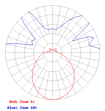 | ||||||||||||||||||
| Azimuth | Ratio | Azimuth | Ratio | Azimuth | Ratio | Azimuth | Ratio | ||||||||||||
| 9 | 0.050 | 19 | 0.060 | 29 | 0.080 | 39 | 0.100 | ||||||||||||
| 49 | 0.110 | 59 | 0.050 | 69 | 0.090 | 79 | 0.080 | ||||||||||||
| 89 | 0.120 | 99 | 0.190 | 109 | 0.290 | 119 | 0.420 | ||||||||||||
| 129 | 0.570 | 139 | 0.700 | 149 | 0.830 | 159 | 0.920 | ||||||||||||
| 169 | 0.970 | 179 | 1.000 | 189 | 0.970 | 199 | 0.900 | ||||||||||||
| 209 | 0.800 | 219 | 0.680 | 229 | 0.540 | 239 | 0.410 | ||||||||||||
| 249 | 0.310 | 259 | 0.240 | 269 | 0.170 | 279 | 0.110 | ||||||||||||
| 289 | 0.050 | 299 | 0.050 | 309 | 0.050 | 319 | 0.100 | ||||||||||||
| 329 | 0.100 | 339 | 0.060 | 349 | 0.050 | 359 | 0.050 | ||||||||||||
Structure Registration Number 1005833 [ASR Heights Differ from WXRV-FM5 Application] Structure Type: 3BPOLE Registered To: JOHN HANCOCK MUTUAL LIFE INSURANCE COMPANY Structure Address: 200 Clarendon Street ( Pole 1) Boston, MA County Name: Suffolk County ASR Issued: 02/17/1998 Date Built: 01/01/1975 Site Elevation: 5.5 m (18 ft.) Structure Height: 239.9 m (787 ft.) Height Overall: 259.7 m (852 ft.) Overall Height AMSL: 265.2 m (870 ft.) Paint & Light FAA Chapters: 2 42-20-57.0 N 71-04-29.0 W (NAD 83) 42-20-56.6 N 71-04-30.8 W (Converted to NAD 27) |
288 South River Road Bedford, NH 03110 Phone: 603-668-6400 Corporation | Date: 12/21/2018 Application Certifier BEANPOT LICENSE CORP. 288 South River Road Bedford, NH 03110 Applicant BERT GOLDMAN 560 Perkins Way Auburn, CA 95603 TECHNICAL CONSULTANT BARRY A. FRIEDMAN Thompson Hine Llp Suite 700 1919 M Street, N.w. Washington, DC 20036 | |||||||||||||||||