
FCCInfo.com
A Service of Cavell, Mertz & Associates, Inc.
(855) FCC-INFO
|
|
|
|
|
||||||||||||||||
|
|
KCDA Channel: 276C1 103.1 MHz Post Falls, Idaho Service: FM - A full-service FM station or application. Facility ID: 57625 Fac. Service: FM Analog & Digital Status: License 73.215 Station Application Accepted: 09/08/2003 Application Granted: 10/01/2003 File Number: BLH-20030908ACL License Expires: 00/00/0000 Prefix Type: This is a license for a commercial FM station Application Type: License To Cover FCC Website Links: LMS Facility Details This Application CDBS Application Other KCDA Applications Other KCDA Applications in CDBS Including Superseded Applications Mailing Address Correspondence for KCDA Correspondence related to application BLH-20030908ACL Service Contour - Open Street Map or USGS Map (60 dBu) Service Contour - KML / Google Earth (60 dBu) Public Inspection Files History Cards for KCDA Facility Type: FM STATION Class: C1, A Zone II station; with 50kW-100kW ERP and a class contour distance 52km-72km Site Location: 47-34-51.6 N 117-17-50.7 W (NAD 83) Site Location: 47-34-52.0 N 117-17-47.0 W (Converted to NAD 27) Effective Radiated Power: 18.5 kW Transmitter Output Power: 8 kW Antenna Center HAAT: 531 m (1742 ft.) Antenna Center AMSL: 1251 m (4104 ft.) Antenna Center HAG: 140 m (459 ft.) Calculated Site Elevation: 1111 m. (3645 ft.) Height Overall*: 276 m (906 ft.) (* As Filed In This Application, may differ from ASR Data, Below.) Directional Antenna Antenna Make/Model: Jampro JBCP-M-8R-RFR-DA Antenna ID: 43300 Polarization: | ||||||||||||||||||
| Antenna Data for Antenna Id: 43300 KCDA FM File: BLH-20030908ACL Jampro - JBCP-M-8R-RFR-DA Service: FM | 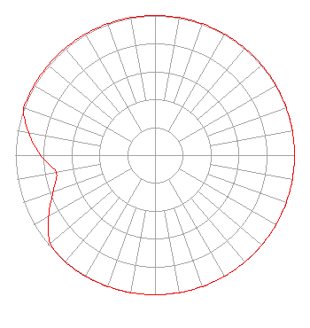 | ||||||||||||||||||
| Azimuth | Ratio | Azimuth | Ratio | Azimuth | Ratio | Azimuth | Ratio | ||||||||||||
| 0 | 1.000 | 10 | 1.000 | 20 | 1.000 | 30 | 1.000 | ||||||||||||
| 40 | 1.000 | 50 | 1.000 | 60 | 1.000 | 70 | 1.000 | ||||||||||||
| 80 | 1.000 | 90 | 1.000 | 100 | 1.000 | 110 | 1.000 | ||||||||||||
| 120 | 1.000 | 130 | 1.000 | 140 | 1.000 | 150 | 1.000 | ||||||||||||
| 160 | 1.000 | 170 | 1.000 | 180 | 1.000 | 190 | 1.000 | ||||||||||||
| 200 | 1.000 | 210 | 1.000 | 220 | 1.000 | 230 | 0.980 | ||||||||||||
| 240 | 0.880 | 250 | 0.780 | 260 | 0.720 | 270 | 0.820 | ||||||||||||
| 280 | 0.920 | 290 | 1.000 | 300 | 1.000 | 310 | 1.000 | ||||||||||||
| 320 | 1.000 | 330 | 1.000 | 340 | 1.000 | 350 | 1.000 | ||||||||||||
Structure Registration Number 1032881 Structure Type: TOWER Registered To: KHQ, INCORPORATED Structure Address: -3.25 Miles Se Spokane, WA County Name: Spokane County ASR Issued: 01/27/2011 Date Built: 01/01/1960 Site Elevation: 1111 m (3645 ft.) Structure Height: 253 m (830 ft.) Height Overall: 276 m (906 ft.) Overall Height AMSL: 1387 m (4551 ft.) Paint & Light FAA Chapters: 1, 3, 7, 16, 21 47-34-52.0 N 117-17-51.0 W (NAD 83) 47-34-52.4 N 117-17-47.3 W (Converted to NAD 27) |
7136 S. Yale Avenue Suite 501 Tulsa, OK 74136 Phone: 918-664-4581 | Date: 09/08/2003 Application Certifier CAPSTAR TX LIMITED PARTNERSHIP 2625 S Memorial Dr Ste A Tulsa, OK 74129-2623 Applicant TROY G. LANGHAM 2625 S. Memorial Drive Suite A Tulsa, OK 74120-2623 FCC ENGINEERING SPECIALIST MARISSA G. REPP Hogan & Hartson Llp | |||||||||||||||||
| |||||||||||||||||||