
FCCInfo.com
A Service of Cavell, Mertz & Associates, Inc.
(855) FCC-INFO
|
|
WLYD from 03/03/2005 WLYD from 03/18/1996 WLYD from 06/08/1993 |
|  |
|
|||||||||||||||
|
|
WLYD Channel: 228A 93.5 MHz Chandler, Indiana Service: FM - A full-service FM station or application. Facility ID: 73350 Fac. Service: FM Status: License Application Accepted: 03/26/1996 Application Granted: 05/08/2003 File Number: BLH-19960326KC License Expires: 00/00/0000 Prefix Type: This is a license for a commercial FM station Application Type: License To Cover FCC Website Links: LMS Facility Details This Application CDBS Application Other WLYD Applications Other WLYD Applications in CDBS Including Superseded Applications Mailing Address Correspondence for WLYD Correspondence related to application BLH-19960326KC Service Contour - Open Street Map or USGS Map (60 dBu) Service Contour - KML / Google Earth (60 dBu) Public Inspection Files Facility Type: FM STATION Class: A, A Zone I; I-A; or II station; with 0.1kW-6kW ERP and a class contour distance <=28km Site Location: 38-01-27.2 N 87-21-43.0 W (NAD 83) Site Location: 38-01-27.0 N 87-21-43.0 W (Converted to NAD 27) Effective Radiated Power: 3.2 kW Transmitter Output Power: 3.4 kW Antenna Center HAAT: 136 m (446 ft.) Antenna Center AMSL: 257 m (843 ft.) Antenna Center HAG: 111 m (364 ft.) Site Elevation: 146.3 m. (480 ft.) Height Overall*: 174 m (571 ft.) (* As Filed In This Application, may differ from ASR Data, Below.) Directional Antenna Antenna Make/Model: Electronics Research Inc. LP-2E-DA-HW, 2 bays, one-half wavelength apart Antenna ID: 14923 Polarization: | ||||||||||||||||||
| Antenna Data for Antenna Id: 14923 WLYD FM File: BLH-19960326KC Electronics Research Inc. - LP-2E-DA-HW, 2 bays, one-half wavelength apart Service: FM | 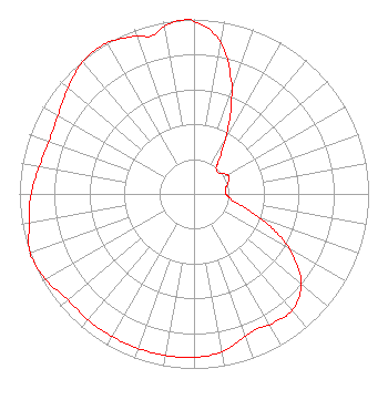 | ||||||||||||||||||
| Azimuth | Ratio | Azimuth | Ratio | Azimuth | Ratio | Azimuth | Ratio | ||||||||||||
| 0 | 0.990 | 10 | 0.881 | 20 | 0.643 | 25 | 0.487 | ||||||||||||
| 30 | 0.358 | 35 | 0.261 | 40 | 0.197 | 50 | 0.186 | ||||||||||||
| 60 | 0.220 | 65 | 0.223 | 70 | 0.210 | 80 | 0.183 | ||||||||||||
| 90 | 0.183 | 100 | 0.224 | 105 | 0.299 | 110 | 0.398 | ||||||||||||
| 115 | 0.520 | 120 | 0.637 | 130 | 0.801 | 140 | 0.872 | ||||||||||||
| 150 | 0.866 | 155 | 0.854 | 160 | 0.868 | 170 | 0.919 | ||||||||||||
| 180 | 0.937 | 190 | 0.939 | 200 | 0.941 | 210 | 0.942 | ||||||||||||
| 220 | 0.943 | 230 | 0.944 | 240 | 0.980 | 249 | 1.000 | ||||||||||||
| 250 | 0.999 | 260 | 0.959 | 270 | 0.933 | 280 | 0.900 | ||||||||||||
| 290 | 0.883 | 300 | 0.899 | 310 | 0.944 | 320 | 0.990 | ||||||||||||
| 325 | 0.999 | 330 | 0.998 | 340 | 0.963 | 345 | 0.937 | ||||||||||||
| 350 | 0.976 | 355 | 0.996 | ||||||||||||||||
Structure Registration Number 1030376 Structure Type: TOWER Registered To: Midwest Communications, Inc. = WLFW Structure Address: Old Plank Rd 1.77 Km S Chandler, IN County Name: Warrick County ASR Issued: 09/03/2014 Date Built: 11/01/1956 Site Elevation: 146.3 m (480 ft.) Structure Height: 139 m (456 ft.) Height Overall: 173.7 m (570 ft.) Overall Height AMSL: 320 m (1050 ft.) FAA Determination: 09/02/1969 FAA Study #: 69-CHI-348-OE Paint & Light FAA Chapters: 1 PAINT ONLY - NO LIGHTING REQUIRED PROVIDED 1013 FOOT REMAINS LIGHTED. 38-01-27.0 N 87-21-43.0 W (NAD 83) 38-01-26.8 N 87-21-43.0 W (Converted to NAD 27) |
904 Grand Ave. Wausau, WI 54403 Phone: 000-000-0000 Corporation | Date: 03/26/1996 Application Certifier SOUTH CENTRAL COMMUNICATIONS CORP. South Central Communications Corporation Po Box 3848 Evansville, IN 47736 Applicant | |||||||||||||||||
|
| ||||||||||||||||||