
FCCInfo.com
A Service of Cavell, Mertz & Associates, Inc.
(855) FCC-INFO
|
|
W221DR from 12/06/2013 |
|
|
||||||||||||||||
|
|
W221DR Channel: 221D 92.1 MHz Morgantown, West Virginia Service: FX - A translator or application for a translator. Facility ID: 139879 Fac. Service: FX Programming Delivery Method: Unspecified Status: License Application Accepted: 01/23/2017 Application Granted: 02/08/2017 File Number: BLFT-20170123FKZ License Expires: 00/00/0000 Prefix Type: This is a license for a translator Application Type: License To Cover FCC Website Links: LMS Facility Details This Application CDBS Application Other W221DR Applications Other W221DR Applications in CDBS Including Superseded Applications Mailing Address Correspondence for W221DR Correspondence related to application BLFT-20170123FKZ Service Contour - Open Street Map or USGS Map (60 dBu) Service Contour - KML / Google Earth (60 dBu) Class: D, A Noncommercial educational operating with no more than 10W Site Location: 39-36-26.7 N 79-59-01.4 W (NAD 83) Site Location: 39-36-26.4 N 79-59-02.2 W (Converted to NAD 27) Effective Radiated Power: 0.24 kW Transmitter Output Power: 0.2 kW Antenna Center HAAT: 0 m Antenna Center AMSL: 494 m (1621 ft.) Antenna Center HAG: 76 m (249 ft.) Site Elevation: 418 m. (1371 ft.) Height Overall*: 96 m (315 ft.) (* As Filed In This Application, may differ from ASR Data, Below.) Directional Antenna Antenna Make/Model: None Antenna ID: 126333 Polarization:
| ||||||||||||||||||
| Antenna Data for Antenna Id: 126333 W221DR FX File: BLFT-20170123FKZ None - Service: FX | 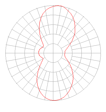 | ||||||||||||||||||
| Azimuth | Ratio | Azimuth | Ratio | Azimuth | Ratio | Azimuth | Ratio | ||||||||||||
| 0 | 0.975 | 10 | 1.000 | 20 | 0.938 | 30 | 0.848 | ||||||||||||
| 40 | 0.719 | 50 | 0.584 | 60 | 0.438 | 70 | 0.324 | ||||||||||||
| 80 | 0.260 | 90 | 0.249 | 100 | 0.250 | 110 | 0.276 | ||||||||||||
| 120 | 0.370 | 130 | 0.508 | 140 | 0.657 | 150 | 0.786 | ||||||||||||
| 160 | 0.897 | 170 | 0.976 | 180 | 0.995 | 190 | 0.947 | ||||||||||||
| 200 | 0.836 | 210 | 0.674 | 220 | 0.477 | 230 | 0.316 | ||||||||||||
| 240 | 0.241 | 250 | 0.262 | 260 | 0.288 | 270 | 0.300 | ||||||||||||
| 280 | 0.296 | 290 | 0.277 | 300 | 0.247 | 310 | 0.268 | ||||||||||||
| 320 | 0.390 | 330 | 0.575 | 340 | 0.759 | 350 | 0.901 | ||||||||||||
Structure Registration Number 1034409 Structure Type: GTOWER Registered To: American Towers LLC Structure Address: 3.5 Km Sw Morgantown, WV County Name: Monongalia County ASR Issued: 10/25/2022 Date Built: 05/07/1991 Site Elevation: 417.9 m (1371 ft.) Structure Height: 91.4 m (300 ft.) Height Overall: 96 m (315 ft.) Overall Height AMSL: 513.9 m (1686 ft.) FAA Determination: 10/17/2022 FAA Study #: 2022-AEA-10076-OE FAA Circular #: 70/7460-1K Paint & Light FAA Chapters: 4, 6, 12 PRIOR STUDY 2009-AEA-844-OE 39-36-26.7 N 79-59-01.4 W (NAD 83) 39-36-26.4 N 79-59-02.2 W (Converted to NAD 27) |
P.o. Box 885 Morgantown, WV 26507 Phone: 304-292-2222 | Date: 01/23/2017 Application Certifier AJG CORPORATION P.o. Box 542 Dellslow, WV 26531 Applicant ROY P. STYPE, III P. O. Box 807 2324 North Cleveland-massillon Road Bath, OH 44210-0807 CONSULTING ENGINEER MATTHEW H. MCCORMICK Fletcher, Heald & Hildreth, Plc 1300 North 17th Street 11th Floor Arlington, VA 22209 | |||||||||||||||||