
FCCInfo.com
A Service of Cavell, Mertz & Associates, Inc.
(855) FCC-INFO
|
|
W275BM from 09/09/2004 |
|
|
||||||||||||||||
|
|
W275BM Channel: 275D 102.9 MHz Jacksonville, Illinois Service: FX - A translator or application for a translator. Facility ID: 144079 Fac. Service: FX Programming Delivery Method: Unspecified Status: License Application Accepted: 03/27/2012 Application Granted: 04/19/2013 File Number: BLFT-20120327AAE License Expires: 00/00/0000 Prefix Type: This is a license for a translator Application Type: License To Cover FCC Website Links: LMS Facility Details This Application CDBS Application Other W275BM Applications Other W275BM Applications in CDBS Including Superseded Applications Mailing Address Correspondence for W275BM Correspondence related to application BLFT-20120327AAE Service Contour - Open Street Map or USGS Map (60 dBu) Service Contour - KML / Google Earth (60 dBu) Class: D, A Noncommercial educational operating with no more than 10W Site Location: 39-43-18.2 N 90-11-45.4 W (NAD 83) Site Location: 39-43-18.0 N 90-11-45.0 W (Converted to NAD 27) Effective Radiated Power: 0.25 kW Transmitter Output Power: 0.47 kW Antenna Center HAAT: 79.8 m Horiz.; 0 m Vert. Antenna Center AMSL: 269 m (883 ft.) Antenna Center HAG: 77 m (253 ft.) Site Elevation: 192 m. (630 ft.) Height Overall*: 103 m (338 ft.) (* As Filed In This Application, may differ from ASR Data, Below.) Directional Antenna Antenna Make/Model: None Antenna ID: 108219 Polarization:
| ||||||||||||||||||
| Antenna Data for Antenna Id: 108219 W275BM FX File: BLFT-20120327AAE None - Service: FX | 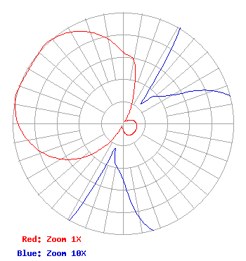 | ||||||||||||||||||
| Azimuth | Ratio | Azimuth | Ratio | Azimuth | Ratio | Azimuth | Ratio | ||||||||||||
| 0 | 0.642 | 10 | 0.570 | 20 | 0.287 | 30 | 0.116 | ||||||||||||
| 40 | 0.029 | 50 | 0.038 | 60 | 0.051 | 70 | 0.086 | ||||||||||||
| 80 | 0.109 | 90 | 0.121 | 100 | 0.127 | 110 | 0.130 | ||||||||||||
| 120 | 0.130 | 130 | 0.130 | 140 | 0.127 | 150 | 0.121 | ||||||||||||
| 160 | 0.109 | 170 | 0.086 | 180 | 0.051 | 190 | 0.038 | ||||||||||||
| 200 | 0.029 | 210 | 0.116 | 220 | 0.287 | 230 | 0.479 | ||||||||||||
| 240 | 0.642 | 250 | 0.772 | 260 | 0.874 | 270 | 0.949 | ||||||||||||
| 280 | 0.989 | 285 | 1.000 | 290 | 0.989 | 300 | 0.979 | ||||||||||||
| 310 | 0.989 | 315 | 1.000 | 320 | 0.989 | 330 | 0.949 | ||||||||||||
| 340 | 0.874 | 350 | 0.772 | ||||||||||||||||
Structure Registration Number 1016068 Structure Type: 4TA4 Registered To: MORGAN COUNTY BROADCASTING COMPANY, INC. Structure Address: Twr 4 E Morton Rd Jacksonville, IL County Name: Morgan County ASR Issued: 04/05/2010 Date Built: 08/29/1986 Site Elevation: 192 m (630 ft.) Structure Height: 102.1 m (335 ft.) Height Overall: 103.1 m (338 ft.) Overall Height AMSL: 295.1 m (968 ft.) FAA Determination: 01/27/1997 FAA Study #: 96-AGL-4361-OE FAA Circular #: 70/7460-1J Paint & Light FAA Chapters: 3, 4, 5, 13 39-43-18.0 N 90-11-45.0 W (NAD 83) 39-43-17.8 N 90-11-44.6 W (Converted to NAD 27) |
1251 Morton Avenue Jacksonville, IL 62650 Phone: 217-245-5519 | Date: 03/27/2012 Application Certifier MORGAN COUNTY BROADCASTING COMPANY, INC. 1251 East Morton Avenue Post Office Box 1055 Jacksonville, IL 62651 Applicant ROBERT WALKER Robert Walker Post Office Box 28961 Austin, TX 78755 ROBERT WALKER Post Office Box 28961 Austin, TX 78755 ATTORNEY/CONSULTANT | |||||||||||||||||