
FCCInfo.com
A Service of Cavell, Mertz & Associates, Inc.
(855) FCC-INFO
|
|
|
|
|
||||||||||||||||
|
|
W204BK Channel: 204D 88.7 MHz Sherwood, Wisconsin Service: FX - A translator or application for a translator. Facility ID: 92654 Fac. Service: FX Programming Delivery Method: Unspecified Status: License Application Accepted: 08/09/2000 Application Granted: 10/10/2000 File Number: BLFT-20000713ABK License Expires: 00/00/0000 Prefix Type: This is a license for a translator Application Type: License To Cover FCC Website Links: LMS Facility Details This Application CDBS Application Other W204BK Applications Other W204BK Applications in CDBS Including Superseded Applications Mailing Address Correspondence for W204BK Correspondence related to application BLFT-20000713ABK Service Contour - Open Street Map or USGS Map (60 dBu) Service Contour - KML / Google Earth (60 dBu) Class: D, A Noncommercial educational operating with no more than 10W Site Location: 44-09-30.0 N 88-17-03.4 W (NAD 83) Site Location: 44-09-30.0 N 88-17-03.0 W (Converted to NAD 27) Effective Radiated Power: 0.01 kW Transmitter Output Power: 0.015 kW Antenna Center HAAT: 160 m Horiz.; 0 m Vert. Antenna Center AMSL: 406 m (1332 ft.) Antenna Center HAG: 101 m (331 ft.) Calculated Site Elevation: 305 m. (1001 ft.) Height Overall*: 104 m (341 ft.) (* As Filed In This Application, may differ from ASR Data, Below.) Directional Antenna Antenna Make/Model: None Antenna ID: 16125 Polarization:
| ||||||||||||||||||
| Antenna Data for Antenna Id: 16125 W204BK FX File: BLFT-20000713ABK None - Service: FX Pattern and Field Values Include a 330° Clockwise Rotation | 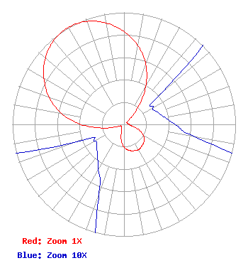 | ||||||||||||||||||
| Azimuth | Ratio | Azimuth | Ratio | Azimuth | Ratio | Azimuth | Ratio | ||||||||||||
| 0 | 0.829 | 10 | 0.715 | 20 | 0.570 | 30 | 0.388 | ||||||||||||
| 40 | 0.187 | 50 | 0.045 | 60 | 0.030 | 70 | 0.032 | ||||||||||||
| 80 | 0.037 | 90 | 0.046 | 100 | 0.065 | 110 | 0.142 | ||||||||||||
| 120 | 0.202 | 130 | 0.234 | 140 | 0.250 | 150 | 0.260 | ||||||||||||
| 160 | 0.250 | 170 | 0.234 | 180 | 0.202 | 190 | 0.142 | ||||||||||||
| 200 | 0.065 | 210 | 0.046 | 220 | 0.037 | 230 | 0.032 | ||||||||||||
| 240 | 0.030 | 250 | 0.045 | 260 | 0.187 | 270 | 0.388 | ||||||||||||
| 280 | 0.570 | 290 | 0.715 | 300 | 0.829 | 310 | 0.920 | ||||||||||||
| 320 | 0.979 | 330 | 1.000 | 340 | 0.979 | 350 | 0.920 | ||||||||||||
Structure Registration Number 1035938 Structure Type: TOWER Registered To: MILWAUKEE REPEATER SERVICE INC Structure Address: N7371 High Cliff Rd Sherwood, WI County Name: Calumet County ASR Issued: 12/16/1997 Date Built: 09/01/1993 Site Elevation: 305.4 m (1002 ft.) Structure Height: 98.5 m (323 ft.) Height Overall: 104.2 m (342 ft.) Overall Height AMSL: 409.6 m (1344 ft.) FAA Determination: 09/21/1992 FAA Study #: 92-AGL-1683-OE FAA Circular #: 70/7460-1H Paint & Light FAA Chapters: 4, 6, 13 44-09-30.0 N 88-17-03.0 W (NAD 83) 44-09-30.0 N 88-17-02.6 W (Converted to NAD 27) |
P.o. Box 391 4002 N. 3300 E. Twin Falls, ID 83303 Phone: 208-733-3133 | Date: 07/13/2000 Application Certifier CALVARY CHAPEL OF TWIN FALLS, INC. 4002 N. 3300 E. Twin Falls, ID 83301 Applicant OFFICER OF THE CORPORATION | |||||||||||||||||