
FCCInfo.com
A Service of Cavell, Mertz & Associates, Inc.
(855) FCC-INFO
|
|
WARV-FM from 03/17/2009 |
|
|
||||||||||||||||
|
|
WARV-FM Channel: 211A 90.1 MHz Colonial Heights, Virginia Service: FM - A full-service FM station or application. Facility ID: 176832 Fac. Service: FM Status: License Application Accepted: 06/22/2010 Application Granted: 06/25/2010 File Number: BLED-20100622ACV License Expires: 00/00/0000 Prefix Type: This is a license for a noncommercial educational FM station Application Type: License To Cover FCC Website Links: LMS Facility Details This Application CDBS Application Other WARV-FM Applications Other WARV-FM Applications in CDBS Including Superseded Applications Mailing Address Correspondence for WARV-FM Correspondence related to application BLED-20100622ACV Service Contour - Open Street Map or USGS Map (60 dBu) Service Contour - KML / Google Earth (60 dBu) Public Inspection Files Facility Type: NON-COMMERCIAL EDUC. FM Class: A, A Zone I; I-A; or II station; with 0.1kW-6kW ERP and a class contour distance <=28km Site Location: 37-15-02.5 N 77-18-21.9 W (NAD 83) Site Location: 37-15-02.0 N 77-18-23.0 W (Converted to NAD 27) Effective Radiated Power: 0.56 kW Transmitter Output Power: 0.605 kW Antenna Center HAAT: 86 m (282 ft.) Antenna Center AMSL: 114 m (374 ft.) Antenna Center HAG: 80 m (262 ft.) Calculated Site Elevation: 34 m. (112 ft.) Height Overall*: 91 m (299 ft.) (* As Filed In This Application, may differ from ASR Data, Below.) Directional Antenna Antenna Make/Model: Electronics Research Inc. 1092-1CP-DA Antenna ID: 100293 Polarization: | ||||||||||||||||||
| Antenna Data for Antenna Id: 100293 WARV-FM FM File: BLED-20100622ACV Electronics Research Inc. - 1092-1CP-DA Service: FM | 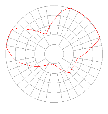 | ||||||||||||||||||
| Azimuth | Ratio | Azimuth | Ratio | Azimuth | Ratio | Azimuth | Ratio | ||||||||||||
| 0 | 0.700 | 10 | 0.880 | 20 | 1.000 | 30 | 1.000 | ||||||||||||
| 40 | 1.000 | 50 | 1.000 | 60 | 1.000 | 70 | 1.000 | ||||||||||||
| 80 | 0.795 | 90 | 0.632 | 100 | 0.502 | 110 | 0.480 | ||||||||||||
| 120 | 0.480 | 130 | 0.480 | 140 | 0.502 | 150 | 0.399 | ||||||||||||
| 160 | 0.317 | 170 | 0.252 | 180 | 0.220 | 190 | 0.230 | ||||||||||||
| 200 | 0.220 | 210 | 0.252 | 220 | 0.317 | 230 | 0.399 | ||||||||||||
| 240 | 0.502 | 250 | 0.632 | 260 | 0.795 | 270 | 0.900 | ||||||||||||
| 280 | 1.000 | 290 | 1.000 | 300 | 1.000 | 310 | 0.795 | ||||||||||||
| 320 | 0.632 | 330 | 0.502 | 340 | 0.450 | 350 | 0.560 | ||||||||||||
Structure Registration Number 1031804 [ASR Heights Differ from WARV-FM Application] Structure Type: LTOWER Registered To: Crown Castle GT Company LLC Structure Address: 5516 Middle Road Prince George, VA County Name: Prince George County ASR Issued: 10/04/2018 Date Built: 12/05/1997 Site Elevation: 29.6 m (97 ft.) Structure Height: 87.5 m (287 ft.) Height Overall: 91.1 m (299 ft.) Overall Height AMSL: 120.7 m (396 ft.) FAA Determination: 09/17/2018 FAA Study #: 2018-AEA-10989-OE FAA Circular #: 70/7460-1J Paint & Light FAA Chapters: 4, 8, 13 PRIOR STUDY 2009-AEA-1426-OE 37-15-06.2 N 77-18-23.5 W (NAD 83) 37-15-05.7 N 77-18-24.6 W (Converted to NAD 27) |
5700 West Oaks Blvd. Rocklin, CA 95765 Phone: 916-251-1600 Not-for-Profit | Date: 06/22/2010 Application Certifier EDUCATIONAL MEDIA FOUNDATION 5700 West Oaks Blvd Rocklin, CA 95765 Applicant SAM WALLINGTON 5700 West Oaks Blvd Rocklin, CA 95765 VP OF ENGINEERING KAREN A. ROSS, ESQ Davis Wright Tremaine Llp | |||||||||||||||||