
FCCInfo.com
A Service of Cavell, Mertz & Associates, Inc.
(855) FCC-INFO
|
|
WMAG from 07/31/1978 |
|
|
|||||||||||||||||||
|
|
WMAG Channel: 258C 99.5 MHz High Point, North Carolina Service: FM - A full-service FM station or application. Facility ID: 73258 Fac. Service: FM Analog & Digital Status: License Application Accepted: 02/07/2011 Application Granted: 03/02/2011 File Number: BMLH-20110207AEO License Expires: 00/00/0000 Prefix Type: This is a modification of a license for a commecial FM station Application Type: Minor Modification FCC Website Links: LMS Facility Details This Application CDBS Application Other WMAG Applications Other WMAG Applications in CDBS Including Superseded Applications Mailing Address Correspondence for WMAG Correspondence related to application BMLH-20110207AEO Service Contour - Open Street Map or USGS Map (60 dBu) Service Contour - KML / Google Earth (60 dBu) Public Inspection Files History Cards for WMAG Facility Type: FM STATION Class: C, A Zone II station; with exactly 100kW ERP and a class contour distance 72km-92km Site Location: 35-52-13.5 N 79-50-24.1 W (NAD 83) Site Location: 35-52-13.0 N 79-50-25.0 W (Converted to NAD 27) Effective Radiated Power: 100 kW Transmitter Output Power: 24.5 kW Antenna Center HAAT: 456 m (1496 ft.) Antenna Center AMSL: 681 m (2234 ft.) Antenna Center HAG: 457 m (1499 ft.) Site Elevation: 224 m. (735 ft.) Height Overall*: 575.9 m (1889 ft.) (* As Filed In This Application, may differ from ASR Data, Below.) Directional Antenna Antenna Make/Model: Electronics Research Inc. SPH-6C D, SIX (6) SECTIONS Antenna ID: 14098 Polarization: | |||||||||||||||||||||
| Antenna Data for Antenna Id: 14098 WMAG FM File: BMLH-20110207AEO Electronics Research Inc. - SPH-6C D, SIX (6) SECTIONS Service: FM | 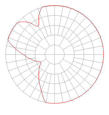 | |||||||||||||||||||||
| Azimuth | Ratio | Azimuth | Ratio | Azimuth | Ratio | Azimuth | Ratio | |||||||||||||||
| 0 | 1.000 | 10 | 1.000 | 20 | 1.000 | 30 | 1.000 | |||||||||||||||
| 40 | 1.000 | 50 | 1.000 | 60 | 1.000 | 70 | 1.000 | |||||||||||||||
| 80 | 1.000 | 90 | 1.000 | 100 | 1.000 | 110 | 1.000 | |||||||||||||||
| 120 | 1.000 | 130 | 1.000 | 140 | 1.000 | 150 | 1.000 | |||||||||||||||
| 160 | 1.000 | 170 | 1.000 | 180 | 1.000 | 190 | 1.000 | |||||||||||||||
| 200 | 0.785 | 210 | 0.630 | 220 | 0.500 | 230 | 0.400 | |||||||||||||||
| 240 | 0.320 | 250 | 0.400 | 260 | 0.510 | 270 | 0.640 | |||||||||||||||
| 280 | 0.840 | 288 | 1.000 | 290 | 1.000 | 300 | 1.000 | |||||||||||||||
| 310 | 1.000 | 320 | 0.860 | 330 | 0.670 | 340 | 0.890 | |||||||||||||||
| 346 | 1.000 | 350 | 1.000 | |||||||||||||||||||
Structure Registration Number 1001558 Structure Type: TOWER Registered To: WFMY Television, LLC Structure Address: 6252 David Country Rd Randleman, NC County Name: Randolph County ASR Issued: 02/13/2019 Date Built: 02/01/2002 Site Elevation: 224 m (735 ft.) Structure Height: 539.5 m (1770 ft.) Height Overall: 575.9 m (1889 ft.) Overall Height AMSL: 799.9 m (2624 ft.) FAA Determination: 12/10/2001 FAA Study #: 01-ASO-9462-OE Paint & Light FAA Chapters: A1, B, G, H OM&L TO REMAIN 24 HR HI STROBES AS PER PRIOR STUDY 78-ASO-1166-OE 35-52-13.5 N 79-50-24.0 W (NAD 83) 35-52-13.0 N 79-50-24.9 W (Converted to NAD 27) |
7136 S. Yale Avenue Suite 501 Tulsa, OK 74136 Phone: 918-664-4581 | Date: 02/07/2011 Application Certifier CAPSTAR TX LLC 2625 S. Memorial Drive, Suite A Tulsa, OK 74129 Applicant TROY G. LANGHAM 2625 S Memorial Drive Suite A Tulsa, OK 74129 FCC ENGINEERING SUPERVISOR CAPSTAR TX LLC Capstar Tx Llc | ||||||||||||||||||||
| ||||||||||||||||||||||