
FCCInfo.com
A Service of Cavell, Mertz & Associates, Inc.
(855) FCC-INFO
|
|
WBGG-FM from 02/24/1983 |
|
|
|||||||||||||||||||
|
|
WBGG-FM Channel: 290C0 105.9 MHz Fort Lauderdale, Florida Service: FM - A full-service FM station or application. Facility ID: 11965 Fac. Service: FM Analog & Digital Status: License 73.215 Station Application Accepted: 04/25/2003 Application Granted: 05/01/2003 File Number: BLH-20030425ABI License Expires: 00/00/0000 Prefix Type: This is a license for a commercial FM station Application Type: License To Cover FCC Website Links: LMS Facility Details This Application CDBS Application Other WBGG-FM Applications Other WBGG-FM Applications in CDBS Including Superseded Applications Mailing Address Correspondence for WBGG-FM Correspondence related to application BLH-20030425ABI Service Contour - Open Street Map or USGS Map (60 dBu) Service Contour - KML / Google Earth (60 dBu) Public Inspection Files History Cards for WBGG-FM Facility Type: FM STATION Class: C0, C0 Site Location: 25-59-35.3 N 80-10-26.2 W (NAD 83) Site Location: 25-59-34.0 N 80-10-27.0 W (Converted to NAD 27) Effective Radiated Power: 100 kW Transmitter Output Power: 36 kW Antenna Center HAAT: 314 m (1030 ft.) Antenna Center AMSL: 314 m (1030 ft.) Antenna Center HAG: 311 m (1020 ft.) Calculated Site Elevation: 3 m. (10 ft.) Height Overall*: 317 m (1040 ft.) (* As Filed In This Application, may differ from ASR Data, Below.) Directional Antenna Antenna Make/Model: Electronics Research Inc. 205-4AI, 4 section Antenna ID: 43642 Polarization: | |||||||||||||||||||||
| Antenna Data for Antenna Id: 43642 WBGG-FM FM File: BLH-20030425ABI Electronics Research Inc. - 205-4AI, 4 section Service: FM | 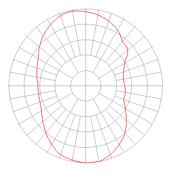 | |||||||||||||||||||||
| Azimuth | Ratio | Azimuth | Ratio | Azimuth | Ratio | Azimuth | Ratio | |||||||||||||||
| 0 | 0.960 | 10 | 0.930 | 20 | 0.890 | 30 | 0.830 | |||||||||||||||
| 40 | 0.750 | 50 | 0.715 | 60 | 0.590 | 70 | 0.530 | |||||||||||||||
| 80 | 0.500 | 90 | 0.510 | 100 | 0.525 | 110 | 0.530 | |||||||||||||||
| 120 | 0.600 | 130 | 0.690 | 140 | 0.800 | 150 | 0.880 | |||||||||||||||
| 160 | 0.950 | 170 | 1.000 | 180 | 1.000 | 190 | 0.980 | |||||||||||||||
| 200 | 0.950 | 210 | 0.880 | 220 | 0.800 | 230 | 0.725 | |||||||||||||||
| 240 | 0.660 | 250 | 0.630 | 260 | 0.620 | 270 | 0.620 | |||||||||||||||
| 280 | 0.640 | 290 | 0.670 | 300 | 0.710 | 310 | 0.780 | |||||||||||||||
| 320 | 0.850 | 330 | 0.910 | 340 | 0.960 | 350 | 0.980 | |||||||||||||||
Structure Registration Number 1018585 [ASR Heights Differ from WBGG-FM Application] Structure Type: GTOWER Registered To: American Towers LLC Structure Address: 3324 Pembroke Rd (candlabra / 005010) Pembroke Park, FL County Name: Broward County ASR Issued: 05/16/2017 Date Built: 01/01/1969 Site Elevation: 2.4 m (8 ft.) Structure Height: 303.3 m (995 ft.) Height Overall: 317.3 m (1041 ft.) Overall Height AMSL: 319.7 m (1049 ft.) FAA Determination: 06/20/2011 FAA Study #: 2011-ASO-1206-OE FAA Circular #: 70/7460-1K Paint & Light FAA Chapters: 4, 7, 12 PRIOR STUDY 2007-ASO-726-OE 25-59-35.3 N 80-10-26.0 W (NAD 83) 25-59-34.0 N 80-10-26.8 W (Converted to NAD 27) |
7136 S. Yale Avenue Tulsa, OK 74136 Phone: 918-664-4581 | Date: 04/25/2003 Application Certifier CLEAR CHANNEL BROADCASTING LICENSES, INC. 7136 S. Yale Avenue Suite 501 Tulsa, OK 74136-2623 Applicant MARISSA G. REPP Hogan & Hartson L.l.p. TROY G. LANGHAM Ok Suite A Tulsa, OK 74129 FCC ENGINEERING SPECIALIST | ||||||||||||||||||||
| ||||||||||||||||||||||