
FCCInfo.com
A Service of Cavell, Mertz & Associates, Inc.
(855) FCC-INFO
|
|
|
|
|
||||||||||||||||
|
|
K236CB Channel: 236D 95.1 MHz Tremonton, Utah Service: FX - A translator or application for a translator. Facility ID: 146450 Fac. Service: FX Programming Delivery Method: Unspecified Status: License Application Accepted: 11/03/2014 Application Granted: 12/05/2014 File Number: BLFT-20141103AFD License Expires: 00/00/0000 Prefix Type: This is a license for a translator Application Type: License To Cover FCC Website Links: LMS Facility Details This Application CDBS Application Other K236CB Applications Other K236CB Applications in CDBS Including Superseded Applications Mailing Address Correspondence for K236CB Correspondence related to application BLFT-20141103AFD Service Contour - Open Street Map or USGS Map (60 dBu) Service Contour - KML / Google Earth (60 dBu) Class: D, A Noncommercial educational operating with no more than 10W Site Location: 41-44-53.7 N 112-13-39.8 W (NAD 83) Site Location: 41-44-54.0 N 112-13-37.0 W (Converted to NAD 27) Effective Radiated Power: 0 kW Horiz. ; 0.25 kW Vert. Transmitter Output Power: 0.252 kW Antenna Center HAAT: 303.4 m Horiz.; 0 m Vert. Antenna Center AMSL: 0 m Horiz.; 1765 m Vert. Antenna Center HAG: 0 m Horiz.; 25 m Vert. Site Elevation: 1740 m. (5709 ft.) Height Overall*: 91 m (299 ft.) (* As Filed In This Application, may differ from ASR Data, Below.) Directional Antenna Antenna Make/Model: None Antenna ID: 31326 Polarization:
| ||||||||||||||||||
| Antenna Data for Antenna Id: 31326 K236CB FX File: BLFT-20141103AFD None - Service: FX Pattern and Field Values Include a 170° Clockwise Rotation | 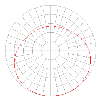 | ||||||||||||||||||
| Azimuth | Ratio | Azimuth | Ratio | Azimuth | Ratio | Azimuth | Ratio | ||||||||||||
| 0 | 0.535 | 10 | 0.540 | 20 | 0.549 | 30 | 0.566 | ||||||||||||
| 40 | 0.592 | 50 | 0.630 | 60 | 0.679 | 70 | 0.735 | ||||||||||||
| 80 | 0.792 | 90 | 0.845 | 100 | 0.892 | 110 | 0.929 | ||||||||||||
| 120 | 0.956 | 130 | 0.975 | 140 | 0.987 | 150 | 0.995 | ||||||||||||
| 160 | 0.999 | 170 | 1.000 | 180 | 0.999 | 190 | 0.995 | ||||||||||||
| 200 | 0.987 | 210 | 0.975 | 220 | 0.956 | 230 | 0.929 | ||||||||||||
| 240 | 0.892 | 250 | 0.845 | 260 | 0.792 | 270 | 0.735 | ||||||||||||
| 280 | 0.679 | 290 | 0.630 | 300 | 0.592 | 310 | 0.566 | ||||||||||||
| 320 | 0.549 | 330 | 0.540 | 340 | 0.535 | 350 | 0.534 | ||||||||||||
Structure Registration Number 1057791 Structure Type: TOWER Registered To: FRANDSEN MEDIA COMPANY, LLC Structure Address: Lookout Mountain Tremonton, UT County Name: Box Elder County ASR Issued: 02/08/2008 Date Built: 04/28/1999 Site Elevation: 1740.4 m (5710 ft.) Structure Height: 90.5 m (297 ft.) Height Overall: 91.4 m (300 ft.) Overall Height AMSL: 1831.8 m (6010 ft.) FAA Determination: 03/16/1999 FAA Study #: 98-ANM-1122-OE FAA Circular #: 70/7460-1J Paint & Light FAA Chapters: 3, 4, 5, 13 REFER TO PRIOR STUDY 98-ANM-0338-OE 41-44-54.0 N 112-13-40.0 W (NAD 83) 41-44-54.3 N 112-13-37.2 W (Converted to NAD 27) |
P.o. Box 570 Logan, UT 84321 Phone: 435-752-1390 | Date: 11/03/2014 Application Certifier SUN VALLEY RADIO, INC. P.o. Box 570 Logan, UT 84323 Applicant GENE WISNIEWSKI 1472 East 3100 South Wendell, ID 83355 CONSULTING ENGINEER DAVID OXENFORD Wilkinson Barker Knauer, Llp 2300 N Street, N.w. Suite 700 Washington, DC 20037-1128 | |||||||||||||||||