
FCCInfo.com
A Service of Cavell, Mertz & Associates, Inc.
(855) FCC-INFO
|
|
|
|
|
||||||||||||||||
|
|
WQOH-FM Channel: 204A 88.7 MHz Springville, Alabama Service: FM - A full-service FM station or application. Facility ID: 174604 Fac. Service: FM Status: License Application Accepted: 04/18/2012 Application Granted: 09/28/2012 File Number: BLED-20120418ABZ License Expires: 00/00/0000 Prefix Type: This is a license for a noncommercial educational FM station Application Type: Amendment FCC Website Links: LMS Facility Details This Application CDBS Application Other WQOH-FM Applications Other WQOH-FM Applications in CDBS Including Superseded Applications Mailing Address Correspondence for WQOH-FM Correspondence related to application BLED-20120418ABZ Service Contour - Open Street Map or USGS Map (60 dBu) Service Contour - KML / Google Earth (60 dBu) Public Inspection Files Facility Type: NON-COMMERCIAL EDUC. FM Class: A, A Zone I; I-A; or II station; with 0.1kW-6kW ERP and a class contour distance <=28km Site Location: 33-54-29.0 N 86-17-08.6 W (NAD 83) Site Location: 33-54-28.6 N 86-17-08.7 W (Converted to NAD 27) Effective Radiated Power: 0.001 kW Horiz. ; 0.44 kW Vert. Transmitter Output Power: 0.409 kW Antenna Center HAAT: 260.9 m (856 ft.) Antenna Center AMSL: 517.5 m (1698 ft.) Antenna Center HAG: 65.5 m (215 ft.) Calculated Site Elevation: 452 m. (1483 ft.) Height Overall*: 81 m (266 ft.) (* As Filed In This Application, may differ from ASR Data, Below.) Directional Antenna Antenna Make/Model: Propagation System Inc PSIFMLV-1-DA Antenna ID: 110655 Polarization: | ||||||||||||||||||
| Antenna Data for Antenna Id: 110655 WQOH-FM FM File: BLED-20120418ABZ Propagation System Inc - PSIFMLV-1-DA Service: FM | 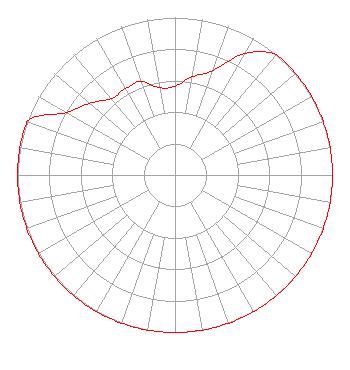 | ||||||||||||||||||
| Azimuth | Ratio | Azimuth | Ratio | Azimuth | Ratio | Azimuth | Ratio | ||||||||||||
| 0 | 0.563 | 10 | 0.632 | 20 | 0.708 | 30 | 0.890 | ||||||||||||
| 40 | 1.000 | 50 | 1.000 | 60 | 1.000 | 70 | 1.000 | ||||||||||||
| 80 | 1.000 | 90 | 1.000 | 100 | 1.000 | 110 | 1.000 | ||||||||||||
| 120 | 1.000 | 130 | 1.000 | 140 | 1.000 | 150 | 1.000 | ||||||||||||
| 160 | 1.000 | 170 | 1.000 | 180 | 1.000 | 190 | 1.000 | ||||||||||||
| 200 | 1.000 | 210 | 1.000 | 220 | 1.000 | 230 | 1.000 | ||||||||||||
| 240 | 1.000 | 250 | 1.000 | 260 | 1.000 | 270 | 1.000 | ||||||||||||
| 280 | 1.000 | 290 | 1.000 | 300 | 0.795 | 310 | 0.708 | ||||||||||||
| 320 | 0.632 | 330 | 0.632 | 340 | 0.632 | 350 | 0.563 | ||||||||||||
Structure Registration Number 1029280 Structure Type: TOWER Registered To: Crown Castle GT Company LLC Structure Address: 3701 Loop Rd Steele, AL County Name: St. Clair County ASR Issued: 05/06/2016 Date Built: 01/01/1995 Site Elevation: 452 m (1483 ft.) Structure Height: 79.2 m (260 ft.) Height Overall: 81.1 m (266 ft.) Overall Height AMSL: 533.1 m (1749 ft.) FAA Determination: 03/22/2012 FAA Study #: 2012-ASO-2603-OE FAA Circular #: 70/7460-1K Paint & Light FAA Chapters: 4, 8, 12 PRIOR STUDY 2011-ASO-2013-OE 33-54-28.9 N 86-17-08.6 W (NAD 83) 33-54-28.5 N 86-17-08.7 W (Converted to NAD 27) Crown Castle 1029280 - CROWN CASTLE GT COMPANY LLC |
1406 E. Garden Lane Midland, TX 79701 Phone: 432-682-1485 | Date: 04/18/2012 Application Certifier DIVINE WORD COMMUNICATIONS 600 W. Gregory Street Pensacola, FL 32561 Applicant ALAN F KILGORE, CPBE 416 Polczinski Circle Oconto Falls, WI 54154 CONSULTING ENGINEER ALAN F KILGORE, CPBE Kilgore Broadcast Maintenance | |||||||||||||||||