
FCCInfo.com
A Service of Cavell, Mertz & Associates, Inc.
(855) FCC-INFO
|
|
KSKE-FM1 from 06/08/2005 |
|
|
||||||||||||||||
|
|
KSKE-FM1 Channel: 269D 101.7 MHz Glenwood Springs, Colorado Service: FB - A booster station or application for a booster. Facility ID: 164731 Fac. Service: FB Programming Delivery Method: Unspecified Status: License Application Accepted: 05/29/2008 Application Granted: 06/16/2008 File Number: BLFTB-20080529AEJ License Expires: 00/00/0000 Prefix Type: This is a license for a booster Application Type: License To Cover FCC Website Links: LMS Facility Details This Application CDBS Application Other KSKE-FM1 Applications Other KSKE-FM1 Applications in CDBS Including Superseded Applications Mailing Address Correspondence for KSKE-FM1 Correspondence related to application BLFTB-20080529AEJ Service Contour - Open Street Map or USGS Map (60 dBu) Service Contour - KML / Google Earth (60 dBu) Facility Type: FM STATION Class: D, A Noncommercial educational operating with no more than 10W Site Location: 39-33-39.9 N 107-19-02.2 W (NAD 83) Site Location: 39-33-40.0 N 107-19-00.0 W (Converted to NAD 27) Effective Radiated Power: 0 kW Horiz. ; 0.6 kW Vert. Transmitter Output Power: 0.372 kW Antenna Center HAAT: 0 m Antenna Center AMSL: 0 m Horiz.; 2216 m Vert. Antenna Center HAG: 0 m Horiz.; 9 m Vert. Site Elevation: 2207 m. (7241 ft.) Height Overall*: 10 m (33 ft.) (* As Filed In This Application, may differ from ASR Data, Below.) Directional Antenna Antenna Make/Model: None Antenna ID: 69748 Polarization:
| ||||||||||||||||||
| Antenna Data for Antenna Id: 69748 KSKE-FM1 FB File: BLFTB-20080529AEJ None - Service: FB | 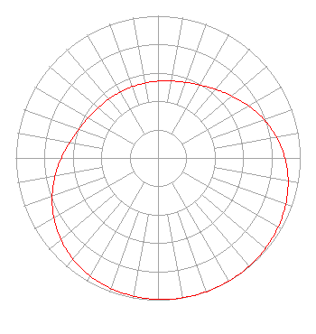 | ||||||||||||||||||
| Azimuth | Ratio | Azimuth | Ratio | Azimuth | Ratio | Azimuth | Ratio | ||||||||||||
| 0 | 0.540 | 10 | 0.549 | 20 | 0.566 | 30 | 0.592 | ||||||||||||
| 40 | 0.630 | 50 | 0.679 | 60 | 0.735 | 70 | 0.792 | ||||||||||||
| 80 | 0.845 | 90 | 0.892 | 100 | 0.929 | 110 | 0.956 | ||||||||||||
| 120 | 0.975 | 130 | 0.987 | 140 | 0.995 | 150 | 0.999 | ||||||||||||
| 160 | 1.000 | 170 | 0.999 | 180 | 0.995 | 190 | 0.987 | ||||||||||||
| 200 | 0.975 | 210 | 0.956 | 220 | 0.929 | 230 | 0.892 | ||||||||||||
| 240 | 0.845 | 250 | 0.792 | 260 | 0.735 | 270 | 0.679 | ||||||||||||
| 280 | 0.630 | 290 | 0.592 | 300 | 0.566 | 310 | 0.549 | ||||||||||||
| 320 | 0.540 | 330 | 0.535 | 340 | 0.534 | 350 | 0.535 | ||||||||||||
Structure Registration Number 1248658 [ASR Heights Differ from KSKE-FM1 Application] Structure Type: GTOWER Registered To: POW, Inc. Structure Address: Iron Mountain, 1.3 Miles N Of Glenwood Springs, CO County Name: Garfield County ASR Issued: 06/13/2018 Date Built: 06/10/2000 Site Elevation: 2210.4 m (7252 ft.) Structure Height: 13.4 m (44 ft.) Height Overall: 13.4 m (44 ft.) Overall Height AMSL: 2223.8 m (7296 ft.) FAA Determination: 03/19/2018 FAA Study #: 2018-ANM-692-OE Paint & Light FAA Chapters: NONE PRIOR STUDY 2005-ANM-959-OE 39-33-43.5 N 107-19-02.6 W (NAD 83) 39-33-43.6 N 107-19-00.4 W (Converted to NAD 27) |
5670 Greenwood Plaza Blvd. Suite 506 Greenwood Village, CO 80111 Phone: 720-726-7770 | Date: 05/29/2008 Application Certifier NRC BROADCASTING MOUNTAIN GROUP, LLC 1201 Eighteenth Street Suite 250 Denver, CO 80202 Applicant MICHAEL J. PLUTA, SR. 1201 18th Street Suite 200 Denver, CO 80202 VP OF ENGINEERING AND OPERATIONS BRENDAN HOLLAND Davis Wright Tremaine Llp 1919 Pennsylvania Ave., Nw Suite 200 Washington, DC 20006 | |||||||||||||||||