
FCCInfo.com
A Service of Cavell, Mertz & Associates, Inc.
(855) FCC-INFO
|
|
W232BW from 04/14/2009 W232BW from 02/09/2006 W232BW from 11/17/2005 W232BW from 05/07/1998 |
|
|
||||||||||||||||
|
|
W232BW Channel: 232D 94.3 MHz Amherst, Massachusetts Service: FX - A translator or application for a translator. Facility ID: 84372 Fac. Service: FX Programming Delivery Method: Unspecified Status: License Application Accepted: 09/13/2018 Application Granted: 10/05/2018 File Number: BLFT-20180913AAT License Expires: 00/00/0000 Prefix Type: This is a license for a translator Application Type: License To Cover FCC Website Links: LMS Facility Details This Application CDBS Application Other W232BW Applications Other W232BW Applications in CDBS Including Superseded Applications Mailing Address Correspondence for W232BW Correspondence related to application BLFT-20180913AAT Service Contour - Open Street Map or USGS Map (60 dBu) Service Contour - KML / Google Earth (60 dBu) Class: D, A Noncommercial educational operating with no more than 10W Site Location: 42-21-49.3 N 72-25-22.3 W (NAD 83) Site Location: 42-21-49.0 N 72-25-24.0 W (Converted to NAD 27) Effective Radiated Power: 0.25 kW Transmitter Output Power: 0.217 kW Antenna Center HAAT: 0 m Antenna Center AMSL: 404 m Horiz.; 401 m Vert. (1325 ft. Horiz. / 1316 ft. Vert.) Antenna Center HAG: 27 m Horiz.; 24 m Vert. (89 ft. Horiz. / 79 ft. Vert.) Site Elevation: 377 m. (1237 ft.) Height Overall*: 106 m (348 ft.) (* As Filed In This Application, may differ from ASR Data, Below.) Directional Antenna Antenna Make/Model: None Antenna ID: 133282 Polarization:
| ||||||||||||||||||
| Antenna Data for Antenna Id: 133282 W232BW FX File: BLFT-20180913AAT None - Service: FX | 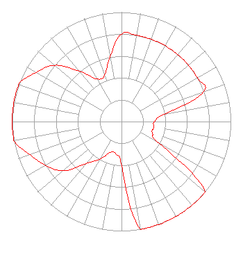 | ||||||||||||||||||
| Azimuth | Ratio | Azimuth | Ratio | Azimuth | Ratio | Azimuth | Ratio | ||||||||||||
| 0 | 0.800 | 10 | 0.800 | 20 | 0.800 | 30 | 0.800 | ||||||||||||
| 40 | 0.800 | 50 | 0.800 | 60 | 0.800 | 70 | 0.800 | ||||||||||||
| 80 | 0.400 | 90 | 0.300 | 100 | 0.300 | 110 | 0.300 | ||||||||||||
| 120 | 0.400 | 130 | 1.000 | 140 | 1.000 | 150 | 1.000 | ||||||||||||
| 160 | 1.000 | 170 | 1.000 | 180 | 0.400 | 190 | 0.300 | ||||||||||||
| 200 | 0.300 | 210 | 0.400 | 220 | 0.500 | 230 | 0.700 | ||||||||||||
| 240 | 0.800 | 250 | 0.890 | 260 | 1.000 | 270 | 1.000 | ||||||||||||
| 280 | 1.000 | 290 | 1.000 | 300 | 0.900 | 310 | 0.800 | ||||||||||||
| 320 | 0.600 | 330 | 0.450 | 340 | 0.450 | 350 | 0.600 | ||||||||||||
Structure Registration Number 1028013 Structure Type: TOWER Registered To: UNIVERSITY OF MASSACHUSETTS DBA = WFCR Structure Address: Summit Of Mount Lincoln Pelham, MA County Name: Hampshire County ASR Issued: 09/05/1997 Date Built: 05/21/1997 Site Elevation: 377.3 m (1238 ft.) Structure Height: 105.5 m (346 ft.) Height Overall: 106.4 m (349 ft.) Overall Height AMSL: 483.7 m (1587 ft.) FAA Determination: 03/21/1994 FAA Study #: 94-ANE-061-OE FAA Circular #: 70/7460-1H Paint & Light FAA Chapters: 3, 4, 5, 13 42-21-49.0 N 72-25-22.0 W (NAD 83) 42-21-48.7 N 72-25-23.7 W (Converted to NAD 27) |
73 Kercheval Avenue Grosse Pointe Farms, MI 48236 Phone: 313-886-7070 | Date: 09/13/2018 Application Certifier SAGA COMMUNICATIONS OF NEW ENGLAND, LLC 73 Kercheval Avenue Grosse Pointe Farms, MI 48236 Applicant JUSTIN ASHER Asher Broadcast Consulting, Llc 579 Babcock Road Bronson, MI 49028-9347 TECHNICAL CONSULTANT GARY S. SMITHWICK, ESQ. Smithwick & Belendiuk, P.c. 5028 Wisconsin Avenue, Nw Suite 301 Washington, DC 20016 | |||||||||||||||||