
FCCInfo.com
A Service of Cavell, Mertz & Associates, Inc.
(855) FCC-INFO
|
|
|
|
|
||||||||||||||||
|
|
K209CF Channel: 209D 89.7 MHz Kearney, Nebraska Service: FX - A translator or application for a translator. Facility ID: 81118 Fac. Service: FX Programming Delivery Method: Unspecified Status: License (Licensed And Silent) Application Accepted: 03/15/2017 Application Granted: 03/20/2017 File Number: BLFT-20170315AAP License Expires: 00/00/0000 Prefix Type: This is a license for a translator Application Type: License To Cover FCC Website Links: LMS Facility Details This Application CDBS Application Other K209CF Applications Other K209CF Applications in CDBS Including Superseded Applications Mailing Address Correspondence for K209CF Correspondence related to application BLFT-20170315AAP Service Contour - Open Street Map or USGS Map (60 dBu) Service Contour - KML / Google Earth (60 dBu) Class: D, A Noncommercial educational operating with no more than 10W Site Location: 40-43-42.0 N 99-07-48.3 W (NAD 83) Site Location: 40-43-42.0 N 99-07-47.0 W (Converted to NAD 27) Effective Radiated Power: 0.25 kW Transmitter Output Power: 0.476 kW Antenna Center HAAT: 0 m Antenna Center AMSL: 776 m (2546 ft.) Antenna Center HAG: 84 m (276 ft.) Site Elevation: 692 m. (2270 ft.) Height Overall*: 97 m (318 ft.) (* As Filed In This Application, may differ from ASR Data, Below.) Directional Antenna Antenna Make/Model: None Antenna ID: 126867 Polarization:
| ||||||||||||||||||
| Antenna Data for Antenna Id: 126867 K209CF FX File: BLFT-20170315AAP None - Service: FX | 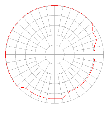 | ||||||||||||||||||
| Azimuth | Ratio | Azimuth | Ratio | Azimuth | Ratio | Azimuth | Ratio | ||||||||||||
| 0 | 1.000 | 10 | 1.000 | 20 | 1.000 | 30 | 1.000 | ||||||||||||
| 40 | 1.000 | 50 | 1.000 | 60 | 0.906 | 70 | 0.906 | ||||||||||||
| 80 | 0.825 | 90 | 0.825 | 100 | 0.825 | 110 | 0.825 | ||||||||||||
| 120 | 0.825 | 130 | 0.825 | 140 | 0.825 | 150 | 0.825 | ||||||||||||
| 160 | 0.825 | 170 | 0.906 | 180 | 0.906 | 190 | 0.906 | ||||||||||||
| 200 | 0.906 | 210 | 0.906 | 220 | 0.906 | 230 | 1.000 | ||||||||||||
| 240 | 1.000 | 250 | 1.000 | 260 | 1.000 | 270 | 1.000 | ||||||||||||
| 280 | 1.000 | 290 | 1.000 | 300 | 1.000 | 310 | 1.000 | ||||||||||||
| 320 | 1.000 | 330 | 1.000 | 340 | 1.000 | 350 | 1.000 | ||||||||||||
Structure Registration Number 1258437 Structure Type: TOWER Registered To: MIDLAND TELECOM, INC Structure Address: .45 Miles West Of Ave 30 And 56th Street Kearney, NE County Name: Buffalo County ASR Issued: 05/23/2007 Date Built: 06/09/2008 Site Elevation: 691.8 m (2270 ft.) Structure Height: 91 m (299 ft.) Height Overall: 96.9 m (318 ft.) Overall Height AMSL: 788.7 m (2588 ft.) FAA Determination: 07/20/1999 FAA Study #: 99-ACE-0749-OE Paint & Light FAA Chapters: A1, H OM&L CONTINUE 24 HOUR MED STROBES. PRIOR FAA 78-ACE-587-OE 40-43-42.0 N 99-07-48.3 W (NAD 83) 40-43-42.0 N 99-07-47.0 W (Converted to NAD 27) |
4002 N. 3300 E. Twin Falls, ID 83301 Phone: 208-734-6633 Not-for-Profit | Date: 03/15/2017 Application Certifier BIBLE BROADCASTING NETWORK, INC. 11530 Carmel Commons Boulevard Charlotte, NC 28226 Applicant JUSTIN ASHER Asher Broadcast Consulting, Llc 579 Babcock Road Bronson, MI 49028-9347 TECHNICAL CONSULTANT GARY S. SMITHWICK Smithwick & Belendiuk, P.c. 5028 Wisconsin Avenue, Nw Suite 301 Washington, DC 20016 | |||||||||||||||||