
FCCInfo.com
A Service of Cavell, Mertz & Associates, Inc.
(855) FCC-INFO
|
|
K285GW from 05/02/2013 |
|
|
||||||||||||||||
|
|
K285GW Channel: 285D 104.9 MHz Tulsa, Oklahoma Service: FX - A translator or application for a translator. Facility ID: 143566 Fac. Service: FX Programming Delivery Method: Unspecified Status: License Application Accepted: 09/04/2019 Application Granted: 09/11/2019 File Number: BLFT-20190904ABY License Expires: 00/00/0000 Prefix Type: This is a license for a translator Application Type: License To Cover FCC Website Links: LMS Facility Details This Application CDBS Application Other K285GW Applications Other K285GW Applications in CDBS Including Superseded Applications Mailing Address Correspondence for K285GW Correspondence related to application BLFT-20190904ABY Service Contour - Open Street Map or USGS Map (60 dBu) Service Contour - KML / Google Earth (60 dBu) Class: D, A Noncommercial educational operating with no more than 10W Site Location: 36-06-25.2 N 95-47-14.4 W (NAD 83) Site Location: 36-06-24.8 N 95-47-13.5 W (Converted to NAD 27) Effective Radiated Power: 0.19 kW Transmitter Output Power: 0.146 kW Antenna Center HAAT: 0 m Antenna Center AMSL: 363 m (1191 ft.) Antenna Center HAG: 121 m (397 ft.) Site Elevation: 242 m. (794 ft.) Height Overall*: 152 m (499 ft.) (* As Filed In This Application, may differ from ASR Data, Below.) Directional Antenna Antenna Make/Model: None Antenna ID: 133578 Polarization:
| ||||||||||||||||||
| Antenna Data for Antenna Id: 133578 K285GW FX File: BLFT-20190904ABY None - Service: FX | 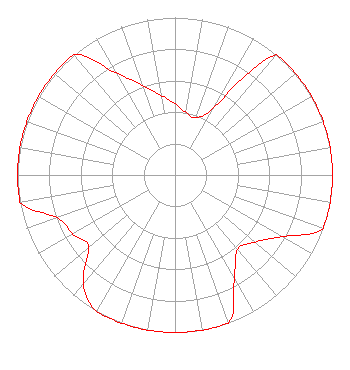 | ||||||||||||||||||
| Azimuth | Ratio | Azimuth | Ratio | Azimuth | Ratio | Azimuth | Ratio | ||||||||||||
| 0 | 0.452 | 10 | 0.403 | 20 | 0.387 | 30 | 0.499 | ||||||||||||
| 40 | 1.000 | 50 | 1.000 | 60 | 1.000 | 70 | 1.000 | ||||||||||||
| 80 | 1.000 | 90 | 1.000 | 100 | 1.000 | 110 | 1.000 | ||||||||||||
| 120 | 0.783 | 130 | 0.662 | 140 | 0.619 | 150 | 0.753 | ||||||||||||
| 160 | 1.000 | 170 | 1.000 | 180 | 1.000 | 190 | 1.000 | ||||||||||||
| 200 | 1.000 | 210 | 1.000 | 220 | 0.905 | 230 | 0.715 | ||||||||||||
| 240 | 0.750 | 250 | 0.796 | 260 | 1.000 | 270 | 1.000 | ||||||||||||
| 280 | 1.000 | 290 | 1.000 | 300 | 1.000 | 310 | 1.000 | ||||||||||||
| 320 | 1.000 | 330 | 0.749 | 340 | 0.607 | 350 | 0.515 | ||||||||||||
Structure Registration Number 1056831 Structure Type: GTOWER Registered To: SBA Structures, LLC Structure Address: 17009 E 41st St Cell Tower (ok20905-a) Tulsa, OK County Name: Tulsa County ASR Issued: 09/01/2023 Date Built: 01/01/1986 Site Elevation: 242.3 m (795 ft.) Structure Height: 146 m (479 ft.) Height Overall: 152.1 m (499 ft.) Overall Height AMSL: 394.4 m (1294 ft.) FAA Determination: 01/30/2023 FAA Study #: 2022-ASW-4666-OE FAA Circular #: 70/7460-1K Paint & Light FAA Chapters: 4, 8, 12 PRIOR STUDY 2001-ASW-3104-OE 36-06-25.1 N 95-47-14.4 W (NAD 83) 36-06-24.7 N 95-47-13.5 W (Converted to NAD 27) |
1920 S. Memorial Drive Tulsa, OK 74112 Phone: 918-406-1683 | Date: 09/04/2019 Application Certifier KEY PLUS BROADCASTING, LLC 1920 South Memorial Drive Tulsa, OK 74112 Applicant DOUG VERNIER 1600 Picturesque Dr. Cedar Falls, IA 50613 ENGINEERING CONSULTANT LAWRENCE BERNSTEIN Law Offices Of Lawrence Bernstein 3510 Springland Ln Nw Washington, DC 20008 | |||||||||||||||||