
FCCInfo.com
A Service of Cavell, Mertz & Associates, Inc.
(855) FCC-INFO
|
|
W261EA from 09/08/2004 |
|
|
||||||||||||||||
|
|
W261EA Channel: 261D 100.1 MHz Atlanta, Georgia Service: FX - A translator or application for a translator. Facility ID: 156732 Fac. Service: FX Programming Delivery Method: Unspecified Status: License Application Accepted: 07/17/2019 Application Granted: 07/24/2019 File Number: BLFT-20190717AAB License Expires: 04/01/2028 Prefix Type: This is a license for a translator Application Type: License To Cover FCC Website Links: LMS Facility Details This Application CDBS Application Other W261EA Applications Other W261EA Applications in CDBS Including Superseded Applications Mailing Address Correspondence for W261EA Correspondence related to application BLFT-20190717AAB Service Contour - Open Street Map or USGS Map (60 dBu) Service Contour - KML / Google Earth (60 dBu) Facility Type: FM STATION Class: D, A Noncommercial educational operating with no more than 10W Site Location: 33-55-01.7 N 84-12-05.6 W (NAD 83) Site Location: 33-55-01.3 N 84-12-05.9 W (Converted to NAD 27) Effective Radiated Power: 0.099 kW Transmitter Output Power: 0.285 kW Antenna Center HAAT: 0 m Antenna Center AMSL: 443 m (1453 ft.) Antenna Center HAG: 111 m (364 ft.) Site Elevation: 332 m. (1089 ft.) Height Overall*: 152 m (499 ft.) (* As Filed In This Application, may differ from ASR Data, Below.) Directional Antenna Antenna Make/Model: None Antenna ID: 134881 Polarization:
| ||||||||||||||||||
| Antenna Data for Antenna Id: 134881 W261EA FX File: BLFT-20190717AAB None - Service: FX Pattern and Field Values Include a 90° Clockwise Rotation | 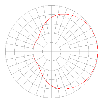 | ||||||||||||||||||
| Azimuth | Ratio | Azimuth | Ratio | Azimuth | Ratio | Azimuth | Ratio | ||||||||||||
| 0 | 0.737 | 10 | 0.804 | 20 | 0.856 | 30 | 0.899 | ||||||||||||
| 40 | 0.939 | 50 | 0.963 | 60 | 0.978 | 70 | 0.989 | ||||||||||||
| 80 | 0.995 | 90 | 1.000 | 100 | 0.995 | 110 | 0.989 | ||||||||||||
| 120 | 0.978 | 130 | 0.963 | 140 | 0.939 | 150 | 0.899 | ||||||||||||
| 160 | 0.856 | 170 | 0.804 | 180 | 0.737 | 190 | 0.650 | ||||||||||||
| 200 | 0.557 | 210 | 0.479 | 220 | 0.423 | 230 | 0.399 | ||||||||||||
| 240 | 0.403 | 250 | 0.398 | 260 | 0.404 | 270 | 0.401 | ||||||||||||
| 280 | 0.404 | 290 | 0.398 | 300 | 0.403 | 310 | 0.399 | ||||||||||||
| 320 | 0.423 | 330 | 0.479 | 340 | 0.557 | 350 | 0.650 | ||||||||||||
Structure Registration Number 1018919 Structure Type: LTOWER Registered To: American Towers LLC Structure Address: 5904 Goshen Springs Road (026012) Norcross, GA County Name: Gwinnett County ASR Issued: 01/07/2013 Date Built: 01/24/2012 Site Elevation: 332.2 m (1090 ft.) Structure Height: 150.9 m (495 ft.) Height Overall: 152.4 m (500 ft.) Overall Height AMSL: 484.6 m (1590 ft.) FAA Determination: 12/17/2012 FAA Study #: 2012-ASO-10374-OE FAA Circular #: 70/7460-1K Paint & Light FAA Chapters: 4, 8, 12 PRIOR STUDY 2010-ASO-3691-OE 33-55-01.3 N 84-12-05.9 W (NAD 83) 33-55-00.9 N 84-12-06.2 W (Converted to NAD 27) |
P.o. Box 48122 Doraville, GA 30362 Phone: 678-898-3332 | Date: 07/17/2019 Application Certifier PRIETO ENTERPRISES, INC. 239 Ezzard St 7702379897 Duluth, GA 30097 Applicant BRUCE BELLAMY Munn-reese Po Box 220 Coldwater, MI 49036 CONSULTING ENGINEER DAVID TILLOTSON Law Office Of David Tillotson 4606 Charleston Terrace, Nw Washington, DC 20007 | |||||||||||||||||