
FCCInfo.com
A Service of Cavell, Mertz & Associates, Inc.
(855) FCC-INFO
|
|
WXLO-FM2 from 11/27/2017 |
|
|
||||||||||||||||
|
|
WXLO-FM2 Channel: 283D 104.5 MHz Lexington, Massachusetts Service: FB - A booster station or application for a booster. Facility ID: 201849 Fac. Service: FB Programming Delivery Method: Unspecified Status: License Application Accepted: 01/14/2019 Application Granted: 02/13/2019 File Number: BLFTB-20190114AAD License Expires: 00/00/0000 Prefix Type: This is a license for a booster Application Type: License To Cover FCC Website Links: LMS Facility Details This Application CDBS Application Other WXLO-FM2 Applications Other WXLO-FM2 Applications in CDBS Including Superseded Applications Mailing Address Correspondence for WXLO-FM2 Correspondence related to application BLFTB-20190114AAD Service Contour - Open Street Map or USGS Map (60 dBu) Service Contour - KML / Google Earth (60 dBu) Facility Type: FM STATION Class: D, A Noncommercial educational operating with no more than 10W Site Location: 42-24-51.1 N 71-12-37.2 W (NAD 83) Site Location: 42-24-50.8 N 71-12-39.0 W (Converted to NAD 27) Effective Radiated Power: 0.15 kW Horiz. ; 0.45 kW Vert. Transmitter Output Power: 0.243 kW Antenna Center HAAT: 0 m Antenna Center AMSL: 143 m (469 ft.) Antenna Center HAG: 89 m (292 ft.) Site Elevation: 54 m. (177 ft.) Height Overall*: 145 m (476 ft.) (* As Filed In This Application, may differ from ASR Data, Below.) Directional Antenna Antenna Make/Model: None Antenna ID: 129430 Polarization:
| ||||||||||||||||||
| Antenna Data for Antenna Id: 129430 WXLO-FM2 FB File: BLFTB-20190114AAD None - Service: FB Pattern and Field Values Include a 90° Clockwise Rotation | 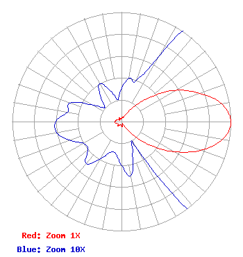 | ||||||||||||||||||
| Azimuth | Ratio | Azimuth | Ratio | Azimuth | Ratio | Azimuth | Ratio | ||||||||||||
| 0 | 0.030 | 10 | 0.040 | 20 | 0.040 | 30 | 0.070 | ||||||||||||
| 40 | 0.180 | 50 | 0.350 | 60 | 0.570 | 70 | 0.760 | ||||||||||||
| 80 | 0.930 | 90 | 1.000 | 100 | 0.940 | 110 | 0.770 | ||||||||||||
| 120 | 0.550 | 130 | 0.330 | 140 | 0.150 | 150 | 0.030 | ||||||||||||
| 160 | 0.030 | 170 | 0.050 | 180 | 0.040 | 190 | 0.030 | ||||||||||||
| 200 | 0.030 | 210 | 0.040 | 220 | 0.050 | 230 | 0.040 | ||||||||||||
| 240 | 0.040 | 250 | 0.050 | 260 | 0.060 | 270 | 0.060 | ||||||||||||
| 280 | 0.050 | 290 | 0.050 | 300 | 0.030 | 310 | 0.020 | ||||||||||||
| 320 | 0.030 | 330 | 0.040 | 340 | 0.030 | 350 | 0.020 | ||||||||||||
Structure Registration Number 1013612 Structure Type: TOWER Registered To: American Towers LLC Structure Address: 75 Concord Ave. ( 002069 ) Lexington, MA County Name: Middlesex County ASR Issued: 01/15/2013 Date Built: 08/05/2004 Site Elevation: 53.6 m (176 ft.) Structure Height: 143.8 m (472 ft.) Height Overall: 145.1 m (476 ft.) Overall Height AMSL: 198.7 m (652 ft.) FAA Determination: 07/09/2004 FAA Study #: 2004-ANE-726-OE FAA Circular #: 70/7460-1J Paint & Light FAA Chapters: 3, 4, 5, 13 OM&L to remain the same as prior study = PAINT/RED LIGHTS 42-24-51.1 N 71-12-37.2 W (NAD 83) 42-24-50.8 N 71-12-39.0 W (Converted to NAD 27) |
3280 Peachtree Road, Nw Suite 2200 Atlanta, GA 30305 Phone: 404-949-0700 Limited Liability Company | Date: 01/14/2019 Application Certifier RADIO LICENSE HOLDING CBC, LLC 3280 Peachtree Road, Nw Suite 2200 Atlanta, GA 30305 Applicant BERT GOLDMAN 560 Perkins Way Auburn, CA 95603 TECHNICAL CONSULTANT ANDREW S. KERSTING, ESQ. Cumulus Media Inc. 3280 Peachtree Road, Nw Suite 2200 Atlanta, GA 30305 | |||||||||||||||||