
FCCInfo.com
A Service of Cavell, Mertz & Associates, Inc.
(855) FCC-INFO
|
|
W273CP from 01/16/2014 |
|
|
||||||||||||||||
|
|
DW273CP Channel: 273D 102.5 MHz New Port Richey, Florida Service: FX - A translator or application for a translator. Facility ID: 158583 Fac. Service: FX Programming Delivery Method: Unspecified Status: License Application Accepted: 12/09/2016 Application Granted: 12/16/2016 File Number: BLFT-20161209AAL License Expires: 00/00/0000 Prefix Type: This is a license for a translator Application Type: Amendment FCC Website Links: LMS Facility Details This Application CDBS Application Other DW273CP Applications Other DW273CP Applications in CDBS Including Superseded Applications Mailing Address Correspondence for DW273CP Correspondence related to application BLFT-20161209AAL Service Contour - Open Street Map or USGS Map (60 dBu) Service Contour - KML / Google Earth (60 dBu) Class: D, A Noncommercial educational operating with no more than 10W Site Location: 28-10-57.0 N 82-46-04.4 W (NAD 83) Site Location: 28-10-56.0 N 82-46-05.0 W (Converted to NAD 27) Effective Radiated Power: 0 kW Horiz. ; 0.25 kW Vert. Transmitter Output Power: 0.049 kW Antenna Center HAAT: 0 m Antenna Center AMSL: 0 m Horiz.; 154 m Vert. Antenna Center HAG: 0 m Horiz.; 152 m Vert. Site Elevation: 2 m. (7 ft.) Height Overall*: 468 m (1535 ft.) (* As Filed In This Application, may differ from ASR Data, Below.) Directional Antenna Antenna Make/Model: None Antenna ID: 124920 Polarization:
| ||||||||||||||||||
| Antenna Data for Antenna Id: 124920 DW273CP FX File: BLFT-20161209AAL None - Service: FX Pattern and Field Values Include a 18° Clockwise Rotation | 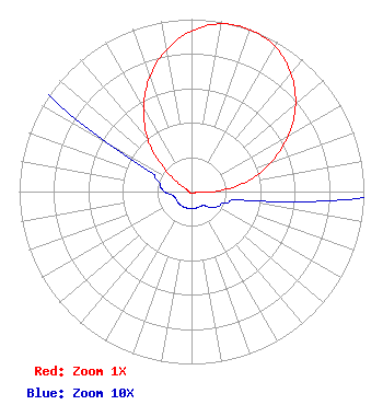 | ||||||||||||||||||
| Azimuth | Ratio | Azimuth | Ratio | Azimuth | Ratio | Azimuth | Ratio | ||||||||||||
| 8 | 0.980 | 18 | 1.000 | 28 | 0.980 | 38 | 0.915 | ||||||||||||
| 48 | 0.813 | 58 | 0.678 | 68 | 0.522 | 78 | 0.360 | ||||||||||||
| 88 | 0.165 | 98 | 0.040 | 108 | 0.021 | 118 | 0.018 | ||||||||||||
| 128 | 0.015 | 138 | 0.011 | 148 | 0.010 | 158 | 0.010 | ||||||||||||
| 168 | 0.010 | 178 | 0.010 | 188 | 0.010 | 198 | 0.010 | ||||||||||||
| 208 | 0.010 | 218 | 0.010 | 228 | 0.010 | 238 | 0.010 | ||||||||||||
| 248 | 0.010 | 258 | 0.011 | 268 | 0.015 | 278 | 0.018 | ||||||||||||
| 288 | 0.021 | 298 | 0.040 | 308 | 0.165 | 318 | 0.360 | ||||||||||||
| 328 | 0.522 | 338 | 0.678 | 348 | 0.813 | 358 | 0.915 | ||||||||||||
Structure Registration Number 1246632 Structure Type: GTOWER Registered To: Vertical Bridge CC FM, LLC Structure Address: 3000 Atlantis Drive Holiday, FL County Name: Pasco County ASR Issued: 12/19/2018 Date Built: 06/30/2009 Site Elevation: 2.1 m (7 ft.) Structure Height: 465.2 m (1526 ft.) Height Overall: 468.1 m (1536 ft.) Overall Height AMSL: 470.2 m (1543 ft.) FAA Determination: 11/12/2015 FAA Study #: 2015-ASO-12897-OE FAA Circular #: 70/7460-1K Paint & Light FAA Chapters: 4, 7, 12 PRIOR STUDY 2006-ASO-4028-OE 28-10-57.4 N 82-46-04.1 W (NAD 83) 28-10-56.4 N 82-46-04.7 W (Converted to NAD 27) |
1601 W. Peachtree Street Ne Atlanta, GA 30309 Phone: 404-897-7000 Limited Liability Company | Date: 12/09/2016 Application Certifier COX RADIO, INC. 11300 Fourth Street North St. Petersburg, FL 33716 Applicant W. JEFFREY REYNOLDS Du Treil, Lundin & Rackley, Inc. 201 Fletcher Avenue Sarasota, FL 34237-6019 TECHNICAL CONSULTANT JOHN S. LOGAN Cooley Llp 1299 Pennsylvania Avenue, Nw Suite 700 Washington, DC 20004 | |||||||||||||||||