
FCCInfo.com
A Service of Cavell, Mertz & Associates, Inc.
(855) FCC-INFO
|
|
|
|
|
||||||||||||||||
|
|
WSMB Channel: 207C3 89.3 MHz Harbor Beach, Michigan Service: FM - A full-service FM station or application. Facility ID: 175249 Fac. Service: FM Status: License Application Accepted: 10/26/2012 Application Granted: 12/17/2012 File Number: BLED-20121026ACG License Expires: 00/00/0000 Prefix Type: This is a license for a noncommercial educational FM station Application Type: Amendment FCC Website Links: LMS Facility Details This Application CDBS Application Other WSMB Applications Other WSMB Applications in CDBS Including Superseded Applications Mailing Address Correspondence for WSMB Correspondence related to application BLED-20121026ACG Service Contour - Open Street Map or USGS Map (60 dBu) Service Contour - KML / Google Earth (60 dBu) Public Inspection Files Facility Type: NON-COMMERCIAL EDUC. FM Class: C3, A Zone II station; with 6kW-25kW ERP and a class contour distance 28km-39km Site Location: 43-41-10.1 N 82-59-39.8 W (NAD 83) Site Location: 43-41-10.0 N 82-59-40.0 W (Converted to NAD 27) Effective Radiated Power: 0.001 kW Horiz. ; 12 kW Vert. Transmitter Output Power: 3 kW Antenna Center HAAT: 145 m (476 ft.) Antenna Center AMSL: 384 m (1260 ft.) Antenna Center HAG: 125 m (410 ft.) Calculated Site Elevation: 259 m. (850 ft.) Height Overall*: 137 m (449 ft.) (* As Filed In This Application, may differ from ASR Data, Below.) Directional Antenna Antenna Make/Model: ETC FM-2V-DA SPECIAL (SLANT) Antenna ID: 96019 Polarization:
| ||||||||||||||||||
| Antenna Data for Antenna Id: 96019 WSMB FM File: BLED-20121026ACG ETC - FM-2V-DA SPECIAL (SLANT) Service: FM | 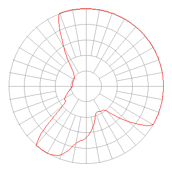 | ||||||||||||||||||
| Azimuth | Ratio | Azimuth | Ratio | Azimuth | Ratio | Azimuth | Ratio | ||||||||||||
| 0 | 1.000 | 10 | 1.000 | 20 | 1.000 | 30 | 1.000 | ||||||||||||
| 40 | 1.000 | 50 | 1.000 | 60 | 1.000 | 70 | 1.000 | ||||||||||||
| 80 | 1.000 | 90 | 1.000 | 100 | 1.000 | 110 | 1.000 | ||||||||||||
| 120 | 1.000 | 130 | 0.711 | 140 | 0.422 | 150 | 0.376 | ||||||||||||
| 160 | 0.376 | 170 | 0.530 | 180 | 0.668 | 190 | 0.750 | ||||||||||||
| 200 | 0.944 | 210 | 1.000 | 220 | 1.000 | 230 | 0.398 | ||||||||||||
| 240 | 0.316 | 250 | 0.251 | 260 | 0.200 | 270 | 0.178 | ||||||||||||
| 280 | 0.178 | 290 | 0.178 | 300 | 0.178 | 310 | 0.200 | ||||||||||||
| 320 | 0.283 | 330 | 0.566 | 340 | 1.000 | 350 | 1.000 | ||||||||||||
Structure Registration Number 1003453 [ASR Heights Differ from WSMB Application] Structure Type: GTOWER Registered To: THUMB RADIO INC Structure Address: On S Bad Axe Rd 8 Mi S Bad Axe, MI County Name: Huron County ASR Issued: 06/06/2018 Date Built: 10/25/1995 Site Elevation: 258.4 m (848 ft.) Structure Height: 137.2 m (450 ft.) Height Overall: 137.2 m (450 ft.) Overall Height AMSL: 395.6 m (1298 ft.) FAA Determination: 01/27/2016 FAA Study #: 2015-AGL-17448-OE FAA Circular #: 70/7460-1H Paint & Light FAA Chapters: 4, 6, 13 PRIOR STUDY 1995-AGL-1804-OE 43-41-07.5 N 82-59-27.8 W (NAD 83) 43-41-07.4 N 82-59-28.0 W (Converted to NAD 27) |
3302 N. Van Dyke Imlay City, MI 48444 Phone: 810-724-2638 | Date: 10/26/2012 Application Certifier SMILE FM 3302 N. Van Dyke Imlay City, MI 48444 Applicant EDWARD CZELADA 3302 N. Van Dyke Rd. Imlay City, MI 48444 PRESIDENT EDWARD CZELADA Smile Fm | |||||||||||||||||