
FCCInfo.com
A Service of Cavell, Mertz & Associates, Inc.
(855) FCC-INFO
|
|
|
|
|
||||||||||||||||
|
|
W289CU Channel: 289D 105.7 MHz Knoxville, Tennessee Service: FX - A translator or application for a translator. Facility ID: 201183 Fac. Service: FX Programming Delivery Method: Unspecified Status: License Application Accepted: 10/04/2018 Application Granted: 11/15/2018 File Number: BLFT-20181004ABC License Expires: 00/00/0000 Prefix Type: This is a license for a translator Application Type: License To Cover FCC Website Links: LMS Facility Details This Application CDBS Application Other W289CU Applications Other W289CU Applications in CDBS Including Superseded Applications Mailing Address Correspondence for W289CU Correspondence related to application BLFT-20181004ABC Service Contour - Open Street Map or USGS Map (60 dBu) Service Contour - KML / Google Earth (60 dBu) Class: D, A Noncommercial educational operating with no more than 10W Site Location: 35-57-20.3 N 83-58-13.7 W (NAD 83) Site Location: 35-57-20.0 N 83-58-14.0 W (Converted to NAD 27) Effective Radiated Power: 0.25 kW Transmitter Output Power: 0.16 kW Antenna Center HAAT: 0 m Antenna Center AMSL: 359 m (1178 ft.) Antenna Center HAG: 97 m (318 ft.) Site Elevation: 262 m. (860 ft.) Height Overall*: 99 m (325 ft.) (* As Filed In This Application, may differ from ASR Data, Below.) Directional Antenna Antenna Make/Model: None Antenna ID: 133085 Polarization:
| ||||||||||||||||||
| Antenna Data for Antenna Id: 133085 W289CU FX File: BLFT-20181004ABC None - Service: FX | 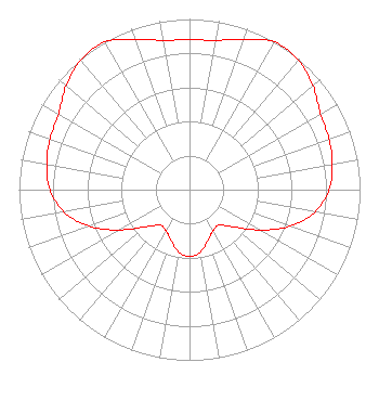 | ||||||||||||||||||
| Azimuth | Ratio | Azimuth | Ratio | Azimuth | Ratio | Azimuth | Ratio | ||||||||||||
| 0 | 0.878 | 10 | 0.889 | 20 | 0.936 | 30 | 0.998 | ||||||||||||
| 40 | 0.992 | 50 | 0.945 | 60 | 0.887 | 70 | 0.870 | ||||||||||||
| 80 | 0.851 | 90 | 0.819 | 100 | 0.748 | 110 | 0.628 | ||||||||||||
| 120 | 0.472 | 130 | 0.339 | 140 | 0.271 | 150 | 0.277 | ||||||||||||
| 160 | 0.316 | 170 | 0.370 | 180 | 0.392 | 190 | 0.370 | ||||||||||||
| 200 | 0.316 | 210 | 0.277 | 220 | 0.271 | 230 | 0.339 | ||||||||||||
| 240 | 0.472 | 250 | 0.628 | 260 | 0.748 | 270 | 0.819 | ||||||||||||
| 280 | 0.851 | 290 | 0.870 | 300 | 0.887 | 310 | 0.945 | ||||||||||||
| 320 | 0.992 | 330 | 0.998 | 340 | 0.936 | 350 | 0.889 | ||||||||||||
Structure Registration Number 1044595 Structure Type: TOWER Registered To: MH2 MEDIA LLC Structure Address: 1017 Cox St Knoxville, TN County Name: Knox County ASR Issued: 01/04/2024 Date Built: 08/03/1973 Site Elevation: 262.1 m (860 ft.) Structure Height: 98.5 m (323 ft.) Height Overall: 99.4 m (326 ft.) Overall Height AMSL: 361.5 m (1186 ft.) FAA Determination: 12/15/1972 FAA Study #: 72-SO-2087-OE Paint & Light FAA Chapters: 1, 3, 12, 21 RED LIGHTS/PAINT 35-57-20.0 N 83-58-14.0 W (NAD 83) 35-57-19.7 N 83-58-14.3 W (Converted to NAD 27) |
1125 Ansley Woods Way Knoxville, TN 37923 Phone: 865-389-2393 Limited Liability Company | Date: 10/04/2018 Application Certifier HODGES MEDIA, LLC 729 Hidden Glen Drive Knoxville, TN 37922 Applicant CLYDE SCOTT, JR. Eme Communications 293 Jc Saunders Road Moultrie, GA 31768-0349 CONSULTING ENGINEER FRANK R. JAZZO, ESQ. Fletcher, Heald & Hildreth, P.l.c. 1300 North 17th Street Suite 1100 Arlington, VA 22209 | |||||||||||||||||