
FCCInfo.com
A Service of Cavell, Mertz & Associates, Inc.
(855) FCC-INFO
|
|
|
|
|
||||||||||||||||
|
|
W221DG Channel: 221D 92.1 MHz Exton, Pennsylvania Service: FX - A translator or application for a translator. Facility ID: 142298 Fac. Service: FX Programming Delivery Method: Unspecified Status: License Application Accepted: 01/06/2017 Application Granted: 02/07/2020 File Number: BLFT-20170106ACP License Expires: 00/00/0000 Prefix Type: This is a license for a translator Application Type: License To Cover FCC Website Links: LMS Facility Details This Application CDBS Application Other W221DG Applications Other W221DG Applications in CDBS Including Superseded Applications Mailing Address Correspondence for W221DG Correspondence related to application BLFT-20170106ACP Service Contour - Open Street Map or USGS Map (60 dBu) Service Contour - KML / Google Earth (60 dBu) Class: D, A Noncommercial educational operating with no more than 10W Site Location: 40-03-31.6 N 75-35-52.8 W (NAD 83) Site Location: 40-03-31.2 N 75-35-54.1 W (Converted to NAD 27) Effective Radiated Power: 0.17 kW Transmitter Output Power: 0.14 kW Antenna Center HAAT: 0 m Antenna Center AMSL: 309 m (1014 ft.) Antenna Center HAG: 90 m (295 ft.) Site Elevation: 219 m. (719 ft.) Height Overall*: 137 m (449 ft.) (* As Filed In This Application, may differ from ASR Data, Below.) Directional Antenna Antenna Make/Model: None Antenna ID: 124919 Polarization:
| ||||||||||||||||||
| Antenna Data for Antenna Id: 124919 W221DG FX File: BLFT-20170106ACP None - Service: FX | 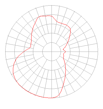 | ||||||||||||||||||
| Azimuth | Ratio | Azimuth | Ratio | Azimuth | Ratio | Azimuth | Ratio | ||||||||||||
| 0 | 0.763 | 10 | 0.660 | 20 | 0.645 | 30 | 0.655 | ||||||||||||
| 40 | 0.630 | 50 | 0.512 | 60 | 0.407 | 70 | 0.323 | ||||||||||||
| 80 | 0.257 | 90 | 0.301 | 100 | 0.266 | 110 | 0.281 | ||||||||||||
| 120 | 0.298 | 130 | 0.375 | 140 | 0.473 | 150 | 0.595 | ||||||||||||
| 160 | 0.749 | 170 | 0.944 | 180 | 1.000 | 190 | 1.000 | ||||||||||||
| 200 | 1.000 | 210 | 1.000 | 220 | 1.000 | 230 | 0.990 | ||||||||||||
| 240 | 0.951 | 250 | 0.870 | 260 | 0.749 | 270 | 0.595 | ||||||||||||
| 280 | 0.473 | 290 | 0.473 | 300 | 0.501 | 310 | 0.562 | ||||||||||||
| 320 | 0.630 | 330 | 0.707 | 340 | 0.794 | 350 | 0.778 | ||||||||||||
Structure Registration Number 1030858 Structure Type: LTOWER Registered To: American Towers LLC Structure Address: 67-d Valley Hill Rd. Charlestown Twp. 3 Phase (010100) Malvern, PA County Name: Chester County ASR Issued: 10/03/2022 Date Built: 05/01/2006 Site Elevation: 219.2 m (719 ft.) Structure Height: 132 m (433 ft.) Height Overall: 137.2 m (450 ft.) Overall Height AMSL: 356.4 m (1169 ft.) FAA Determination: 09/30/2022 FAA Study #: 2021-AEA-15689-OE FAA Circular #: 70/7460-1K Paint & Light FAA Chapters: 4, 8, 12 PRIOR STUDY 2011-AEA-3228-OE 40-03-31.6 N 75-35-52.8 W (NAD 83) 40-03-31.2 N 75-35-54.1 W (Converted to NAD 27) |
1240 Horseshoe Trail Malvern, PA 19355 Phone: 610-917-3000 | Date: 01/06/2017 Application Certifier BROADCAST SCIENCES LLC 1240 Horseshoe Trail Malvern, PA 19355 Applicant JEFFREY J DEPOLO 1240 Horseshoe Trail Malvern, PA 19355 MANAGING MEMBER BROADCAST SCIENCES LLC Broadcast Sciences Llc 1240 Horseshoe Trail Malvern, PA 19355 | |||||||||||||||||