
FCCInfo.com
A Service of Cavell, Mertz & Associates, Inc.
(855) FCC-INFO
|
|
W261DI from 05/26/2004 |
|
|
||||||||||||||||
|
|
W261DI Channel: 261D 100.1 MHz Norfolk, Virginia Service: FX - A translator or application for a translator. Facility ID: 142287 Fac. Service: FX Programming Delivery Method: Unspecified Status: License Application Accepted: 04/13/2017 Application Granted: 04/20/2017 File Number: BLFT-20170413AAS License Expires: 00/00/0000 Prefix Type: This is a license for a translator Application Type: License To Cover FCC Website Links: LMS Facility Details This Application CDBS Application Other W261DI Applications Other W261DI Applications in CDBS Including Superseded Applications Mailing Address Correspondence for W261DI Correspondence related to application BLFT-20170413AAS Service Contour - Open Street Map or USGS Map (60 dBu) Service Contour - KML / Google Earth (60 dBu) Class: D, A Noncommercial educational operating with no more than 10W Site Location: 36-48-37.5 N 76-16-56.8 W (NAD 83) Site Location: 36-48-37.0 N 76-16-58.0 W (Converted to NAD 27) Effective Radiated Power: 0.225 kW Transmitter Output Power: 0.54 kW Antenna Center HAAT: 0 m Antenna Center AMSL: 137 m (449 ft.) Antenna Center HAG: 134 m (440 ft.) Site Elevation: 3 m. (10 ft.) Height Overall*: 163 m (535 ft.) (* As Filed In This Application, may differ from ASR Data, Below.) Directional Antenna Antenna Make/Model: None Antenna ID: 126802 Polarization:
| ||||||||||||||||||
| Antenna Data for Antenna Id: 126802 W261DI FX File: BLFT-20170413AAS None - Service: FX | 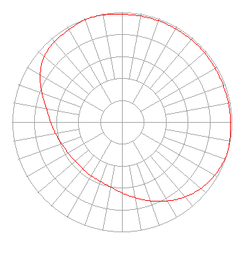 | ||||||||||||||||||
| Azimuth | Ratio | Azimuth | Ratio | Azimuth | Ratio | Azimuth | Ratio | ||||||||||||
| 0 | 0.980 | 10 | 0.980 | 20 | 0.980 | 30 | 0.980 | ||||||||||||
| 40 | 0.980 | 50 | 0.980 | 60 | 0.980 | 70 | 0.980 | ||||||||||||
| 80 | 0.985 | 90 | 0.990 | 100 | 0.995 | 105 | 1.000 | ||||||||||||
| 110 | 0.995 | 120 | 0.975 | 130 | 0.940 | 140 | 0.890 | ||||||||||||
| 150 | 0.830 | 160 | 0.765 | 170 | 0.700 | 180 | 0.645 | ||||||||||||
| 190 | 0.600 | 200 | 0.575 | 210 | 0.565 | 220 | 0.555 | ||||||||||||
| 230 | 0.555 | 240 | 0.565 | 250 | 0.585 | 260 | 0.615 | ||||||||||||
| 270 | 0.650 | 280 | 0.700 | 290 | 0.775 | 300 | 0.860 | ||||||||||||
| 310 | 0.925 | 320 | 0.955 | 330 | 0.970 | 340 | 0.990 | ||||||||||||
| 350 | 0.990 | ||||||||||||||||||
Structure Registration Number 1053614 Structure Type: GTOWER Registered To: SpectraSite Communications, LLC. through American Towers, LLC. Structure Address: 95 Poindexter Street (310331) Chesapeake, VA County Name: Chesapeake city ASR Issued: 11/21/2019 Date Built: 11/05/2008 Site Elevation: 2.7 m (9 ft.) Structure Height: 161.8 m (531 ft.) Height Overall: 163 m (535 ft.) Overall Height AMSL: 165.7 m (544 ft.) FAA Determination: 11/20/2019 FAA Study #: 2019-AEA-13343-OE FAA Circular #: 70/7460-1L Paint & Light FAA Chapters: 4, 8, 12 PRIOR STUDY 2010-AEA-1484-OE 36-48-37.4 N 76-16-57.2 W (NAD 83) 36-48-36.9 N 76-16-58.4 W (Converted to NAD 27) |
3780 Will Scarlet Road Winston-salem, NC 27104 Phone: 336-765-7438 Not-for-Profit | Date: 04/13/2017 Application Certifier DELMARVA EDUCATIONAL ASSOCIATION 3780 Will Scarlet Road Winston-salem, NC 27104 Applicant CARL GLUCK Carl T. Jones Corp 7901 Yarnwood Court Springfield, VA 22153-2899 TECHNICAL CONSULTANT DAVINA S. SASHKIN, ESQ. Fletcher, Heald & Hildreth, Plc 1300 North 17th Street 11th Floor Arlington, VA 22209 | |||||||||||||||||