
FCCInfo.com
A Service of Cavell, Mertz & Associates, Inc.
(855) FCC-INFO
|
|
W283DN from 06/16/2017 W283DN from 04/14/2017 W283DN from 04/14/2014 |
|
|
||||||||||||||||
|
|
W283DN Channel: 283D 104.5 MHz Harrisburg, Pennsylvania Service: FX - A translator or application for a translator. Facility ID: 147362 Fac. Service: FX Programming Delivery Method: Unspecified Status: Construction Permit Application Accepted: 07/29/2016 Application Granted: 09/06/2018 File Number: BMPFT-20160729AEV W283DN CP Expires: 03/06/2020 Prefix Type: This is a modification of construction permit for a translator Application Type: Minor Modification FCC Website Links: LMS Facility Details This Application CDBS Application Other W283DN Applications Other W283DN Applications in CDBS Including Superseded Applications Mailing Address Correspondence for W283DN Correspondence related to application BMPFT-20160729AEV Service Contour - Open Street Map or USGS Map (60 dBu) Service Contour - KML / Google Earth (60 dBu) Class: D, A Noncommercial educational operating with no more than 10W Site Location: 40-19-02.0 N 76-56-48.0 W (NAD 83) Site Location: 40-19-01.7 N 76-56-49.1 W (Converted to NAD 27) Effective Radiated Power: 0.25 kW Antenna Center HAAT: 0 m Antenna Center AMSL: 405 m (1329 ft.) Antenna Center HAG: 72 m (236 ft.) Site Elevation: 333 m. (1093 ft.) Height Overall*: 121 m (397 ft.) (* As Filed In This Application, may differ from ASR Data, Below.) Directional Antenna Antenna Make/Model: None Antenna ID: 125209 Polarization:
| ||||||||||||||||||
| Antenna Data for Antenna Id: 125209 W283DN FX File: BMPFT-20160729AEV None - Service: FX | 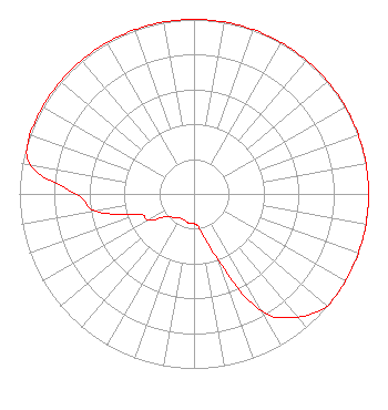 | ||||||||||||||||||
| Azimuth | Ratio | Azimuth | Ratio | Azimuth | Ratio | Azimuth | Ratio | ||||||||||||
| 0 | 1.000 | 10 | 1.000 | 20 | 1.000 | 30 | 1.000 | ||||||||||||
| 40 | 1.000 | 50 | 1.000 | 60 | 1.000 | 70 | 1.000 | ||||||||||||
| 80 | 1.000 | 90 | 1.000 | 100 | 1.000 | 110 | 1.000 | ||||||||||||
| 120 | 1.000 | 130 | 1.000 | 140 | 0.920 | 150 | 0.777 | ||||||||||||
| 160 | 0.400 | 170 | 0.210 | 180 | 0.170 | 190 | 0.170 | ||||||||||||
| 200 | 0.160 | 210 | 0.160 | 220 | 0.180 | 230 | 0.200 | ||||||||||||
| 240 | 0.300 | 250 | 0.340 | 260 | 0.570 | 270 | 0.676 | ||||||||||||
| 280 | 0.948 | 290 | 1.000 | 300 | 1.000 | 310 | 1.000 | ||||||||||||
| 320 | 1.000 | 330 | 1.000 | 340 | 1.000 | 350 | 1.000 | ||||||||||||
Structure Registration Number 1030631 [ASR Heights Differ from W283DN Application] Structure Type: TOWER Registered To: Pinnacle Towers LLC Structure Address: Tower Rd Summerdale, PA County Name: Cumberland County ASR Issued: 05/06/2016 Date Built: 05/29/1997 Site Elevation: 332.2 m (1090 ft.) Structure Height: 117 m (384 ft.) Height Overall: 121.3 m (398 ft.) Overall Height AMSL: 453.5 m (1488 ft.) FAA Determination: 07/28/2010 FAA Study #: 2010-AEA-1450-OE Paint & Light FAA Chapters: A2, H Continue As Is OM&L = 24-HR MED-STROBES 40-19-02.0 N 76-56-48.0 W (NAD 83) 40-19-01.7 N 76-56-49.1 W (Converted to NAD 27) |
Po Box 367 Haddon Heights, NJ 08035 Phone: 717-910-4000 | Date: 07/29/2016 Application Certifier EDWARD A. SCHOBER 402 Tenth Avenue P.o. Box 367 Haddon Heights, NJ 08035-0367 Applicant EDWARD SCHOBER, PE 402 Tenth Avenue Po Box 367 Haddon Heights, NJ 08035-0367 SELF EDWARD A. SCHOBER Radiotechniques Engineering, Llc 402 Tenth Avenue P.o. Box 367 Haddon Heights, NJ 08035 | |||||||||||||||||