
FCCInfo.com
A Service of Cavell, Mertz & Associates, Inc.
(855) FCC-INFO
|
|
|
|
|
||||||||||||||||
|
|
WQNS Channel: 286A 105.1 MHz Woodfin, North Carolina Service: FM - A full-service FM station or application. Facility ID: 41008 Fac. Service: FM Analog & Digital Status: License 73.215 Station Application Accepted: 08/07/2015 Application Granted: 11/10/2015 File Number: BLH-20150807AAE License Expires: 00/00/0000 Prefix Type: This is a license for a commercial FM station Application Type: License To Cover FCC Website Links: LMS Facility Details This Application CDBS Application Other WQNS Applications Other WQNS Applications in CDBS Including Superseded Applications Mailing Address Correspondence for WQNS Correspondence related to application BLH-20150807AAE Service Contour - Open Street Map or USGS Map (60 dBu) Service Contour - KML / Google Earth (60 dBu) Public Inspection Files History Cards for WQNS Facility Type: FM STATION Class: A, A Zone I; I-A; or II station; with 0.1kW-6kW ERP and a class contour distance <=28km Site Location: 35-35-50.8 N 82-36-20.1 W (NAD 83) Site Location: 35-35-50.4 N 82-36-20.6 W (Converted to NAD 27) Effective Radiated Power: 6 kW Transmitter Output Power: 2.75 kW Antenna Center HAAT: 62 m (203 ft.) Antenna Center AMSL: 766 m (2513 ft.) Antenna Center HAG: 94 m (308 ft.) Calculated Site Elevation: 672 m. (2205 ft.) Height Overall*: 100 m (328 ft.) (* As Filed In This Application, may differ from ASR Data, Below.) Directional Antenna Antenna Make/Model: Electronics Research Inc. LPX-4C-DA, four sections Antenna ID: 119694 Polarization: | ||||||||||||||||||
| Antenna Data for Antenna Id: 119694 WQNS FM File: BLH-20150807AAE Electronics Research Inc. - LPX-4C-DA, four sections Service: FM | 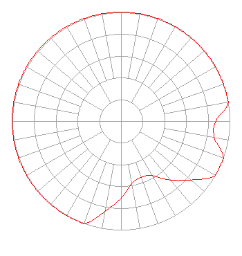 | ||||||||||||||||||
| Azimuth | Ratio | Azimuth | Ratio | Azimuth | Ratio | Azimuth | Ratio | ||||||||||||
| 0 | 1.000 | 10 | 1.000 | 20 | 1.000 | 30 | 1.000 | ||||||||||||
| 40 | 1.000 | 50 | 1.000 | 60 | 1.000 | 70 | 1.000 | ||||||||||||
| 80 | 1.000 | 90 | 0.870 | 100 | 0.870 | 110 | 1.000 | ||||||||||||
| 120 | 1.000 | 130 | 0.841 | 140 | 0.707 | 150 | 0.578 | ||||||||||||
| 160 | 0.549 | 170 | 0.582 | 180 | 0.707 | 190 | 0.841 | ||||||||||||
| 200 | 1.000 | 210 | 1.000 | 220 | 1.000 | 230 | 1.000 | ||||||||||||
| 240 | 1.000 | 250 | 1.000 | 260 | 1.000 | 270 | 1.000 | ||||||||||||
| 280 | 1.000 | 290 | 1.000 | 300 | 1.000 | 310 | 1.000 | ||||||||||||
| 320 | 1.000 | 330 | 1.000 | 340 | 1.000 | 350 | 1.000 | ||||||||||||
Structure Registration Number 1007876 Structure Type: 4TA4 Registered To: Capstar Radio Operating Company Structure Address: Twr 4 13 Summerlin Rd Asheville, NC County Name: Buncombe County ASR Issued: 08/29/2017 Date Built: 11/15/2006 Site Elevation: 672.1 m (2205 ft.) Structure Height: 99.4 m (326 ft.) Height Overall: 100.3 m (329 ft.) Overall Height AMSL: 772.4 m (2534 ft.) FAA Determination: 12/11/2007 FAA Study #: 2007-ASO-6896-OE Paint & Light FAA Chapters: NONE PRIOR STUDY 2006-ASO-2867-OE 35-35-50.8 N 82-36-20.0 W (NAD 83) 35-35-50.4 N 82-36-20.5 W (Converted to NAD 27) |
7136 S. Yale Avenue Tulsa, OK 74136 Phone: 918-664-4581 | Date: 08/07/2015 Application Certifier CLEAR CHANNEL BROADCASTING LICENSES, INC. 2625 S. Memorial Drive Suite A Tulsa, OK 74129-2623 Applicant BENJAMIN BRINITZER 801 Woodridge Center Dr Charlotte, NC 28217 TECHNICAL DIRECTOR TROY LANGHAM Iheartmedia, Inc. | |||||||||||||||||
| |||||||||||||||||||