
FCCInfo.com
A Service of Cavell, Mertz & Associates, Inc.
(855) FCC-INFO
|
|
WYPO from 10/15/1993 WYPO from 02/26/1993 |
|  |
|
|||||||||||||||
|
|
WYPO Channel: 295A 106.9 MHz Ocean City, Maryland Service: FM - A full-service FM station or application. Facility ID: 29564 Fac. Service: FM Status: License 73.215 Station Application Accepted: 08/03/2007 Application Granted: 09/19/2007 File Number: BMLED-20070803ABU License Expires: 00/00/0000 Prefix Type: This is a modification of license for a noncommercial educational FM station Application Type: Minor Modification FCC Website Links: LMS Facility Details This Application CDBS Application Other WYPO Applications Other WYPO Applications in CDBS Including Superseded Applications Mailing Address Correspondence for WYPO Correspondence related to application BMLED-20070803ABU Service Contour - Open Street Map or USGS Map (60 dBu) Service Contour - KML / Google Earth (60 dBu) Public Inspection Files Facility Type: NON-COMMERCIAL EDUC. FM Class: A, A Zone I; I-A; or II station; with 0.1kW-6kW ERP and a class contour distance <=28km Site Location: 38-19-39.4 N 75-11-48.7 W (NAD 83) Site Location: 38-19-39.0 N 75-11-50.0 W (Converted to NAD 27) Effective Radiated Power: 4.5 kW Transmitter Output Power: 3.1 kW Antenna Center HAAT: 117 m (384 ft.) Antenna Center AMSL: 121 m (397 ft.) Antenna Center HAG: 114 m (374 ft.) Calculated Site Elevation: 7 m. (23 ft.) Height Overall*: 118 m (387 ft.) (* As Filed In This Application, may differ from ASR Data, Below.) Directional Antenna Antenna Make/Model: DIELECTRIC SKM2ED Antenna ID: 42541 Polarization: | ||||||||||||||||||
| Antenna Data for Antenna Id: 42541 WYPO FM File: BMLED-20070803ABU DIELECTRIC - SKM2ED Service: FM | 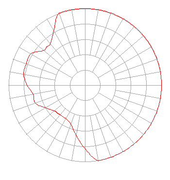 | ||||||||||||||||||
| Azimuth | Ratio | Azimuth | Ratio | Azimuth | Ratio | Azimuth | Ratio | ||||||||||||
| 0 | 1.000 | 10 | 1.000 | 20 | 1.000 | 30 | 1.000 | ||||||||||||
| 40 | 1.000 | 45 | 1.000 | 50 | 1.000 | 60 | 1.000 | ||||||||||||
| 70 | 1.000 | 80 | 1.000 | 90 | 1.000 | 100 | 1.000 | ||||||||||||
| 110 | 1.000 | 120 | 1.000 | 130 | 1.000 | 135 | 1.000 | ||||||||||||
| 140 | 1.000 | 150 | 1.000 | 160 | 1.000 | 170 | 1.000 | ||||||||||||
| 180 | 0.829 | 190 | 0.666 | 200 | 0.541 | 210 | 0.505 | ||||||||||||
| 220 | 0.505 | 225 | 0.514 | 230 | 0.523 | 240 | 0.593 | ||||||||||||
| 250 | 0.689 | 260 | 0.689 | 270 | 0.756 | 280 | 0.816 | ||||||||||||
| 290 | 0.816 | 300 | 0.816 | 310 | 0.707 | 315 | 0.707 | ||||||||||||
| 320 | 0.707 | 330 | 0.816 | 340 | 1.000 | 350 | 1.000 | ||||||||||||
Structure Registration Number 1227587 Structure Type: GTOWER Registered To: American Towers LLC Structure Address: 9696 Mill Haven Road (#204155) Berlin, MD County Name: Worcester County ASR Issued: 01/11/2024 Date Built: 11/01/2004 Site Elevation: 7.3 m (24 ft.) Structure Height: 117.7 m (386 ft.) Height Overall: 118.3 m (388 ft.) Overall Height AMSL: 125.6 m (412 ft.) FAA Determination: 08/28/2023 FAA Study #: 2023-AEA-8761-OE FAA Circular #: 70/7460-1L Paint & Light FAA Chapters: 4, 8, 12 OM&L to remain the same as prior study = A MED-DUAL SYSTEM 38-19-39.7 N 75-11-48.1 W (NAD 83) 38-19-39.3 N 75-11-49.4 W (Converted to NAD 27) |
2216 North Charles Street Baltimore, MD 21218 Phone: 410-235-1660 Limited Liability Company | Date: 08/03/2007 Application Certifier WYPR LICENSE HOLDING, LLC Attn: Anthony Brandon 2216 Charles Street Baltimore, MD 21218 Applicant NO CHANGE FROM BLH-20020703ABD . . ., 00000 . JOHN S, NEELY, ESQ. Miller And Neely, P.c. | |||||||||||||||||