
FCCInfo.com
A Service of Cavell, Mertz & Associates, Inc.
(855) FCC-INFO
|
|
|
|
|
||||||||||||||||
|
|
W277AA Channel: 277D 103.3 MHz Somerset, Kentucky Service: FX - A translator or application for a translator. Facility ID: 71859 Fac. Service: FX Programming Delivery Method: Unspecified Status: License Application Accepted: 11/23/1993 Application Granted: 12/29/1993 File Number: BLFT-19931123TF License Expires: 00/00/0000 Prefix Type: This is a license for a translator Application Type: License To Cover FCC Website Links: LMS Facility Details This Application CDBS Application Other W277AA Applications Other W277AA Applications in CDBS Including Superseded Applications Mailing Address Correspondence for W277AA Correspondence related to application BLFT-19931123TF Service Contour - Open Street Map or USGS Map (60 dBu) Service Contour - KML / Google Earth (60 dBu) Class: D, A Noncommercial educational operating with no more than 10W Site Location: 37-07-03.3 N 84-36-41.8 W (NAD 83) Site Location: 37-07-03.0 N 84-36-42.0 W (Converted to NAD 27) Effective Radiated Power: 0.25 kW Antenna Center HAAT: 89 m (292 ft.) Antenna Center AMSL: 388 m (1273 ft.) Antenna Center HAG: 82 m (269 ft.) Calculated Site Elevation: 306 m. (1004 ft.) Height Overall*: 100 m (328 ft.) (* As Filed In This Application, may differ from ASR Data, Below.) Directional Antenna Antenna Make/Model: None Antenna ID: 14558 Polarization:
| ||||||||||||||||||
| Antenna Data for Antenna Id: 14558 W277AA FX File: BLFT-19931123TF None - Service: FX | 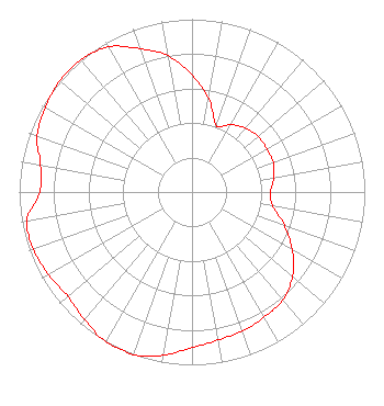 | ||||||||||||||||||
| Azimuth | Ratio | Azimuth | Ratio | Azimuth | Ratio | Azimuth | Ratio | ||||||||||||
| 0 | 0.678 | 10 | 0.550 | 20 | 0.410 | 30 | 0.450 | ||||||||||||
| 40 | 0.482 | 50 | 0.499 | 60 | 0.500 | 70 | 0.500 | ||||||||||||
| 80 | 0.482 | 90 | 0.454 | 100 | 0.476 | 110 | 0.568 | ||||||||||||
| 120 | 0.670 | 130 | 0.760 | 140 | 0.818 | 150 | 0.835 | ||||||||||||
| 160 | 0.856 | 170 | 0.870 | 180 | 0.900 | 190 | 0.959 | ||||||||||||
| 200 | 1.000 | 210 | 1.000 | 220 | 0.965 | 230 | 0.938 | ||||||||||||
| 240 | 0.958 | 250 | 0.975 | 260 | 0.970 | 270 | 0.880 | ||||||||||||
| 280 | 0.890 | 290 | 0.954 | 300 | 0.979 | 310 | 1.000 | ||||||||||||
| 320 | 1.000 | 330 | 0.970 | 340 | 0.883 | 350 | 0.800 | ||||||||||||
Structure Registration Number 1043674 [ASR Heights Differ from W277AA Application] Structure Type: TOWER Registered To: Vertical Bridge Towers, IV LLC Structure Address: 101 First Radio Lane Somerset, KY County Name: Pulaski County ASR Issued: 10/11/2023 Date Built: 09/14/1987 Site Elevation: 310 m (1017 ft.) Structure Height: 99.1 m (325 ft.) Height Overall: 100.4 m (329 ft.) Overall Height AMSL: 410.4 m (1346 ft.) FAA Determination: 06/18/1998 FAA Study #: 98-ASO-3226-OE FAA Circular #: 70/7460-1J Paint & Light FAA Chapters: 3, 4, 5, 13 37-07-03.0 N 84-36-42.0 W (NAD 83) 37-07-02.7 N 84-36-42.2 W (Converted to NAD 27) |
1906 College Heights Blvd Ac153 Bowling Green, KY 42101 Phone: 270-745-6140 Government Entity | Date: 11/23/1993 Application Certifier WESTERN KENTUCKY UNIVERSITY Western Kentucky University 1 Big Red Way Bowling Green, KY 42101 Applicant | |||||||||||||||||