
FCCInfo.com
A Service of Cavell, Mertz & Associates, Inc.
(855) FCC-INFO
|
|
WRUN from 09/06/2007 WRUN from 08/07/1997 |
|  |
|
|||||||||||||||
|
|
WRUN Channel: 212A 90.3 MHz Remsen, New York Service: FM - A full-service FM station or application. Facility ID: 87836 Fac. Service: FM Status: License Application Accepted: 12/11/2008 Application Granted: 12/12/2008 File Number: BLED-20081211AEK License Expires: 00/00/0000 Prefix Type: This is a license for a noncommercial educational FM station Application Type: License To Cover FCC Website Links: LMS Facility Details This Application CDBS Application Other WRUN Applications Other WRUN Applications in CDBS Including Superseded Applications Mailing Address Correspondence for WRUN Correspondence related to application BLED-20081211AEK Service Contour - Open Street Map or USGS Map (60 dBu) Service Contour - KML / Google Earth (60 dBu) Public Inspection Files Facility Type: NON-COMMERCIAL EDUC. FM Class: A, A Zone I; I-A; or II station; with 0.1kW-6kW ERP and a class contour distance <=28km Site Location: 43-20-48.0 N 75-13-57.4 W (NAD 83) Site Location: 43-20-47.8 N 75-13-58.8 W (Converted to NAD 27) Effective Radiated Power: 1.2 kW Transmitter Output Power: 1.34 kW Antenna Center HAAT: 204 m (669 ft.) Antenna Center AMSL: 554.1 m (1818 ft.) Antenna Center HAG: 58.8 m (193 ft.) Calculated Site Elevation: 495.3 m. (1625 ft.) Height Overall*: 79.2 m (260 ft.) (* As Filed In This Application, may differ from ASR Data, Below.) Directional Antenna Antenna Make/Model: DIELECTRIC DCRH2E5RD, two sections, 0.5 wavelength spaced Antenna ID: 89621 Polarization: | ||||||||||||||||||
| Antenna Data for Antenna Id: 89621 WRUN FM File: BLED-20081211AEK DIELECTRIC - DCRH2E5RD, two sections, 0.5 wavelength spaced Service: FM | 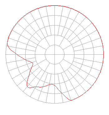 | ||||||||||||||||||
| Azimuth | Ratio | Azimuth | Ratio | Azimuth | Ratio | Azimuth | Ratio | ||||||||||||
| 0 | 1.000 | 10 | 1.000 | 20 | 1.000 | 30 | 1.000 | ||||||||||||
| 40 | 1.000 | 50 | 1.000 | 60 | 1.000 | 70 | 1.000 | ||||||||||||
| 80 | 1.000 | 90 | 1.000 | 100 | 1.000 | 110 | 1.000 | ||||||||||||
| 120 | 1.000 | 130 | 1.000 | 140 | 1.000 | 150 | 1.000 | ||||||||||||
| 155 | 1.000 | 160 | 0.999 | 170 | 0.793 | 180 | 0.630 | ||||||||||||
| 190 | 0.630 | 200 | 0.707 | 210 | 0.767 | 220 | 0.860 | ||||||||||||
| 230 | 0.683 | 240 | 0.543 | 245 | 0.489 | 250 | 0.489 | ||||||||||||
| 260 | 0.609 | 270 | 0.766 | 280 | 0.963 | 290 | 1.000 | ||||||||||||
| 300 | 1.000 | 310 | 1.000 | 320 | 1.000 | 330 | 1.000 | ||||||||||||
| 340 | 1.000 | 350 | 1.000 | ||||||||||||||||
Structure Registration Number 1207144 Structure Type: TOWER Registered To: Crown Atlantic Company LLC Structure Address: 9891 Crowell Road Remsen, NY County Name: Oneida County ASR Issued: 05/06/2016 Date Built: 07/24/2000 Site Elevation: 495.3 m (1625 ft.) Structure Height: 76.2 m (250 ft.) Height Overall: 79.2 m (260 ft.) Overall Height AMSL: 574.5 m (1885 ft.) FAA Determination: 05/21/2008 FAA Study #: 2008-AEA-2227-OE FAA Circular #: 70/7460-1K Paint & Light FAA Chapters: 4, 8, 12 PRIOR STUDY 2002-AEA-2512-OE 43-20-48.0 N 75-13-57.4 W (NAD 83) 43-20-47.8 N 75-13-58.8 W (Converted to NAD 27) |
318 Central Avenue Albany, NY 12206 Phone: 518-465-5233 Not-for-Profit | Date: 12/11/2008 Application Certifier WAMC 318 Central Avenue Albany, NY 12206 Applicant LAURA M. MIZRAHI Communications Technologies, Inc. P. O. Box 1130 Marlton, NJ 08053 TECHNICAL CONSULTANT MARGARET L. MILLER, ESQ. Dow Lohnes Pllc | |||||||||||||||||