
FCCInfo.com
A Service of Cavell, Mertz & Associates, Inc.
(855) FCC-INFO
|
|
K244AH from 04/10/2003 K244AH from 04/11/1984 |
|
|
||||||||||||||||
|
|
K244AH Channel: 244D 96.7 MHz Ukiah, California Service: FX - A translator or application for a translator. Facility ID: 49192 Fac. Service: FX Programming Delivery Method: Unspecified Status: License Application Accepted: 10/01/2015 Application Granted: 10/19/2015 File Number: BLFT-20151001AFS License Expires: 00/00/0000 Prefix Type: This is a license for a translator Application Type: License To Cover FCC Website Links: LMS Facility Details This Application CDBS Application Other K244AH Applications Other K244AH Applications in CDBS Including Superseded Applications Mailing Address Correspondence for K244AH Correspondence related to application BLFT-20151001AFS Service Contour - Open Street Map or USGS Map (60 dBu) Service Contour - KML / Google Earth (60 dBu) Class: D, A Noncommercial educational operating with no more than 10W Site Location: 39-06-56.6 N 123-14-00.0 W (NAD 83) Site Location: 39-06-57.0 N 123-13-56.0 W (Converted to NAD 27) Effective Radiated Power: 0.01 kW Horiz. ; 0 kW Vert. Transmitter Output Power: 0.002 kW Antenna Center HAAT: 0 m Antenna Center AMSL: 770 m Horiz.; 0 m Vert. Antenna Center HAG: 9 m Horiz.; 0 m Vert. Site Elevation: 761 m. (2497 ft.) Height Overall*: 21 m (69 ft.) (* As Filed In This Application, may differ from ASR Data, Below.) Directional Antenna Antenna Make/Model: None Antenna ID: 16179 Polarization:
| ||||||||||||||||||
| Antenna Data for Antenna Id: 16179 K244AH FX File: BLFT-20151001AFS None - Service: FX Pattern and Field Values Include a 30° Clockwise Rotation | 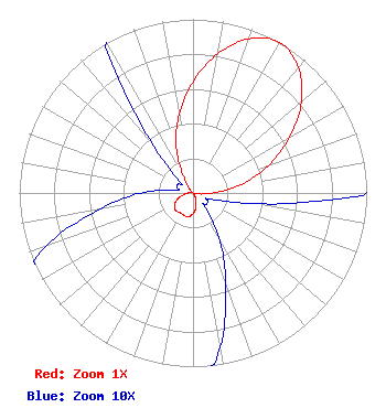 | ||||||||||||||||||
| Azimuth | Ratio | Azimuth | Ratio | Azimuth | Ratio | Azimuth | Ratio | ||||||||||||
| 0 | 0.641 | 10 | 0.813 | 20 | 0.944 | 30 | 1.000 | ||||||||||||
| 40 | 0.944 | 50 | 0.813 | 60 | 0.641 | 70 | 0.460 | ||||||||||||
| 80 | 0.280 | 90 | 0.110 | 100 | 0.035 | 110 | 0.010 | ||||||||||||
| 120 | 0.010 | 130 | 0.010 | 140 | 0.010 | 150 | 0.030 | ||||||||||||
| 160 | 0.055 | 170 | 0.090 | 180 | 0.120 | 190 | 0.138 | ||||||||||||
| 200 | 0.140 | 210 | 0.135 | 220 | 0.140 | 230 | 0.138 | ||||||||||||
| 240 | 0.120 | 250 | 0.090 | 260 | 0.055 | 270 | 0.030 | ||||||||||||
| 280 | 0.010 | 290 | 0.010 | 300 | 0.010 | 310 | 0.010 | ||||||||||||
| 320 | 0.035 | 330 | 0.110 | 340 | 0.280 | 350 | 0.460 | ||||||||||||
Structure Registration Number 1204202 [ASR Heights Differ from K244AH Application] Structure Type: TOWER Structure Address: Cleland Mountain Ukiah, CA County Name: Mendocino County ASR Issued: 11/08/1999 Date Built: 06/09/1999 Site Elevation: 760.5 m (2495 ft.) Structure Height: 21 m (69 ft.) Height Overall: 21 m (69 ft.) Overall Height AMSL: 781.5 m (2564 ft.) FAA Determination: 06/07/1999 FAA Study #: 99-AWP-0707-OE Paint & Light FAA Chapters: NONE Removed expiration date from determination. Scenario 1./jjs/case#635066 39-06-57.0 N 123-14-00.0 W (NAD 83) 39-06-57.4 N 123-13-56.0 W (Converted to NAD 27) |
Raleigh, NC 27606 Phone: 919-280-2248 Individual | Date: 10/01/2015 Application Certifier TOM VAN HESE 05 View Haven Santa Fe, NM 87508 Applicant ERIK C. SWANSON, P.E. Hatfield & Dawson Consulting Engineers, 9500 Greenwood Ave N Seattle, WA 98103 CONSULTING ENGINEER TOM VAN HESE Tom Van Hese 05 View Haven Santa Fe, NM 87508 | |||||||||||||||||