
FCCInfo.com
A Service of Cavell, Mertz & Associates, Inc.
(855) FCC-INFO
|
|
WMAL-FM from 09/17/2009 WMAL-FM from 10/17/1994 WMAL-FM from 01/27/1986 WMAL-FM from 12/09/1981 |
|
|
||||||||||||||||
|
|
WMAL-FM Channel: 290B 105.9 MHz Woodbridge, Virginia Service: FS - A full service FM station auxiliary transmitting antenna or application. Facility ID: 70037 Fac. Service: FM Analog & Digital Status: License Application Accepted: 08/18/1998 Application Granted: 11/27/2001 File Number: BLH-19980818KA License Expires: 00/00/0000 Prefix Type: This is a license for a commercial FM station Application Type: License To Cover FCC Website Links: LMS Facility Details This Application CDBS Application Other WMAL-FM Applications Other WMAL-FM Applications in CDBS Including Superseded Applications Mailing Address Correspondence for WMAL-FM Correspondence related to application BLH-19980818KA Service Contour - Open Street Map or USGS Map (54 dBu) Service Contour - KML / Google Earth (54 dBu) Public Inspection Files History Cards for WMAL-FM Facility Type: FM STATION Class: B, A Zone I or I-A station; with 25kW-50kW ERP and a class contour distance 39km-52km Site Location: 38-53-30.4 N 77-07-53.9 W (NAD 83) Site Location: 38-53-30.0 N 77-07-55.0 W (Converted to NAD 27) Effective Radiated Power: 40 kW Transmitter Output Power: 12.5 kW Antenna Center HAAT: 138 m (453 ft.) Antenna Center AMSL: 204 m (669 ft.) Antenna Center HAG: 91 m (299 ft.) Site Elevation: 113 m. (371 ft.) Height Overall*: 151 m (495 ft.) (* As Filed In This Application, may differ from ASR Data, Below.) Directional Antenna Antenna Make/Model: None Shively 6810-3R-DA, 3 section Antenna ID: 15100 Polarization: | ||||||||||||||||||
| Antenna Data for Antenna Id: 15100 WMAL-FM FS File: BLH-19980818KA None - Shively 6810-3R-DA, 3 section Service: FS | 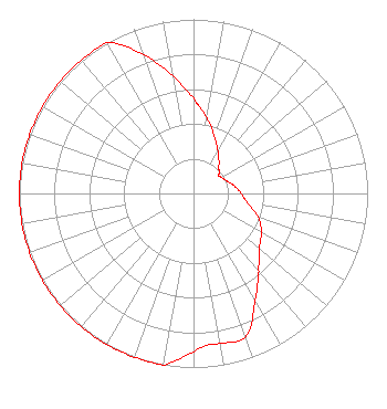 | ||||||||||||||||||
| Azimuth | Ratio | Azimuth | Ratio | Azimuth | Ratio | Azimuth | Ratio | ||||||||||||
| 0 | 0.550 | 4 | 0.500 | 10 | 0.440 | 20 | 0.350 | ||||||||||||
| 30 | 0.280 | 40 | 0.230 | 45 | 0.205 | 50 | 0.195 | ||||||||||||
| 54 | 0.178 | 60 | 0.185 | 70 | 0.205 | 80 | 0.240 | ||||||||||||
| 90 | 0.275 | 100 | 0.315 | 110 | 0.395 | 120 | 0.450 | ||||||||||||
| 130 | 0.490 | 135 | 0.535 | 140 | 0.585 | 150 | 0.710 | ||||||||||||
| 160 | 0.875 | 170 | 0.875 | 175 | 0.875 | 180 | 0.910 | ||||||||||||
| 189 | 0.990 | 190 | 1.000 | 200 | 1.000 | 210 | 1.000 | ||||||||||||
| 220 | 1.000 | 230 | 1.000 | 240 | 1.000 | 250 | 1.000 | ||||||||||||
| 260 | 1.000 | 270 | 1.000 | 280 | 1.000 | 290 | 1.000 | ||||||||||||
| 300 | 1.000 | 310 | 1.000 | 320 | 1.000 | 330 | 1.000 | ||||||||||||
| 340 | 0.850 | 350 | 0.685 | ||||||||||||||||
Structure Registration Number 1018169 Structure Type: LTOWER Registered To: GREATER WASHINGTON EDUCATIONAL TELECOMMUNICATIONS ASSN DBA = WETA FM Structure Address: 5217 19th Rd N Arlington, VA County Name: Arlington County ASR Issued: 01/09/2014 Date Built: 02/12/2014 Site Elevation: 112.8 m (370 ft.) Structure Height: 150 m (492 ft.) Height Overall: 151 m (495 ft.) Overall Height AMSL: 263.8 m (865 ft.) FAA Determination: 01/08/2014 FAA Study #: 2013-AEA-3390-OE FAA Circular #: 70/7460-1J Paint & Light FAA Chapters: 4, 8, 13 PRIOR STUDY 1997-AEA-1573-OE. FAA Chapters 4,8,12 with Bird deviation special condition. 38-53-30.0 N 77-07-54.0 W (NAD 83) 38-53-29.6 N 77-07-55.1 W (Converted to NAD 27) |
780 Johnson Ferry Road Suite 500 Atlanta, GA 30342 Phone: 404-949-0700 Limited Liability Company | Date: 08/18/1998 Application Certifier WMAL, INC. Group W Radio, Inc. (hou./wash.) 77 West 66th Street, 16th Floor Attn: Sam Antar, Esq. New York, NY 10023-6298 Applicant | |||||||||||||||||
| |||||||||||||||||||